Pembrokeshire & South Wales: Pt 5 – Pembroke

Our next stop was the town of Pembroke, famous for the incredible Castle ruins which overlook the town…

Pembroke:

Status: Pembrokeshire, Town, Wales

Date: 08/09/2015

Travel: Car

Eating & Sleeping: Castle Cafe

Attractions: Pembroke Castle, Pembroke River, Mill Pond, War Memorial, St Nicholas Church, Mill Bridge, Clock Tower, St Mary’s Church etc

Pembroke 1

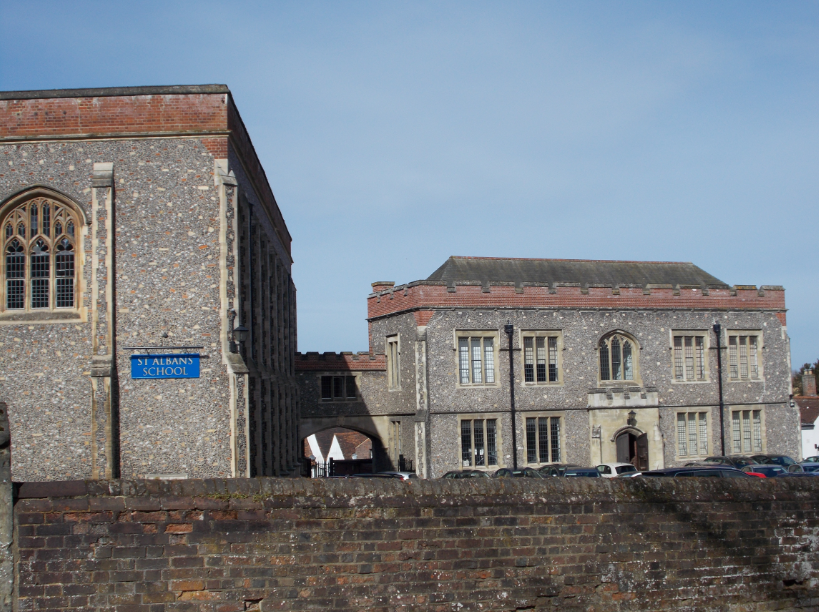
We parked up in the shadow of Pembroke Castle, a mammoth construction high on a rocky outcrop. Wales is famous for its magnificent Castles, such as those in the North at Conwy, Caernarfon and Beaumaris, and this is no exception.

To the right you can see a little path leading off around the Castle Rock, so we followed it to see where we ended up…

Gazing up at the exterior walls, we were in awe of its impressive construction. It’s a stunning building, and has to be 1 of the most fantastic Castles in the whole of South Wales. The path led all the way around the Castle, into the town centre where you can access the Castle’s main entrance.

Also by the main entrance you will find the Pembroke War Memorial, crafted out of Granite in 1924 by TW Colley & Sons, a local firm of Masons. Unveiled by Lieutenant General Sir Francis Lloyd (1853 – 1926, a British Army Officer in charge of the London District branch, helping to protect London from Zeppelin attacks during WWI), it commemorates all those from Pembroke who sadly perished in WWI (and later WWII).

Pembroke 7

The main entrance to the Castle is through the stunning Gatehouse, the full scale of which you can see by looking at the size of the actual entrance at the bottom of the building, compared with it’s overall height!

Two enormous flags emblazon the tops of the twin towers, with the Union Jack on the right, and the Welsh Flag (complete with mighty dragon) on the left. Nearly all of the towers within the Castle Complex are climbable, and whilst we couldn’t get up the flag towers themselves, the slightly shorter ones on either side were fair game, and offered some fantastic views across the rest of the Castle…

Pembroke 5

In this shot we had climbed the walls, and were scaling 1 of the smaller towers. From here we gazed out towards the famous Castle Keep, the tall rounded building at the other end of the complex.

The Keep dates back to the late 12th/early 13th centuries, when William Marshal (1146 – 1219, 1st Earl of Pembroke) purchased Pembroke Castle, which at that time was a much smaller affair, designed in a motte & bailey style, with a central wooden Keep.

Marshal replaced the existing buildings with new, grand stone affairs, starting with the new Keep, and the Inner Ward, the stone structures that surround the Keep. It was bounded by a large stone wall, however as this side was open to the Pembroke River, and at the top of large stone cliffs, the defences weren’t as extensive as at the landward end, which included the Gatehouse I mentioned earlier, with walls that reach multiple metres thick.

By the 13th century a Grand Hall had also been constructed, close to the Keep, to the far right of the 2nd picture. The whole area was contained within a large wall, with access being restricted to a gateway shaped like a horseshoe, which was presumably located just to the left of the great Keep.

The main Gatehouse itself, along with the other towering defensive walls that mark the Castles landward end weren’t built until much later, when the Pembroke family took possession of the Castle in 1247, before it became the property of the Crown. Indeed the English King Henry VII (1457 – 1509) was born here in 1457, becoming King after his forces later famously defeated King Richard III (1452 – 1485), to win the Battle of the Roses for the house of Lancaster.

Sadly, like many great Castles around Britain, it was the Civil War that started the process of decay, as the Parliamentarians captured the Castle in the 1640’s. After a revolt which saw the same forces defect to the Royalists, Oliver Cromwell (1599 – 1658, Ruler of England/Scotland/Wales) himself came and took the town, and gave the order for the Castle to be dismantled, and the building became abandoned. It would eventually be bought however by the Philipps Family in 1880, and Sir Ivor Philipps (1861 – 1940, Major-General in the British Army) began to restore the Castle to some of it’s former glory. Today it remains jointly owned by the Philipps and Pembroke Town Council, and the building itself is in remarkably good condition.

Pembroke 6

You may have by now also noticed the large map of Wales painted on the tarmac in the middle of the Castles Courtyard, which shows the locations of all the major Castles/Religious Sites around the whole of Wales. The map includes Conwy & Caernarfon in North Wales, as well as St David’s Cathedral, and Cardiff Castle amongst many others.

According to the Pembroke Castle Website, The Map is notable for being: “the largest painting in the UK and the largest map of Wales in the world.” Of course you get the best view from the top of the various towers, with the Gatehouse giving the best view of South Wales, and the Keep of North Wales.

Pembroke 8

Speaking of the Keep, we couldn’t resist climbing it as well, and we were treated to a great view, back towards the Gatehouse, and on to Pembroke Town Centre. Pembroke is in a unique setting, with half the town bounded by the Mill Pond and the Pembroke River.

The Castle Keep is a magnificent 75 ft tall, and as such you get the best views in this area of Pembrokeshire. Looking North West, you can see the outer defensive wall of the Castle, with the path we traversed when we arrived down below it.

Off in the distance, we spied the towers of the Pembroke Refinery over at Hundleton, on the far side of the Pembroke River, shown in the foreground. This vast complex has processed Crude Oil for use as various types of fuel since 1964. This eventually had knock on effects for the nearby village of Rhoscrowther, as during the 1990’s, Texaco (who owned the Refinery until 2000) bought most of the houses in the village, and subsequently demolished them, leaving only the centuries old Church, and a scattering of houses left today.

Just in front of the Refinery, directly on the bank of the river is the smaller Pembroke B Power Station, which only actually opened in 2012. It’s the largest Power Station in Europe to be powered by Gas, and it replaced the previous Oil Powered Station on the site which was demolished in the early 2000’s.

Pembroke 11

Turning to look West, the Castle has a rival for the Pembroke skyline, in the form of the “Priory Church of St Nicholas”, which is technically located in the small village of Monkton which is contiguous with Pembroke itself.

The original Church of St Nicholas was tied to Pembroke Castle, as in 1098 the Church was established within the Castle complex. This was long before William Marshal built the incredible structure you can explore today, so it’s thought that the very 1st incarnation of Pembroke Castle was in Monkton not Pembroke. The Church would soon be placed under the administration of the Abbey in the Town of Sees in Normandy, which is part of modern day France. This was presumably a consequence of the Norman Invasion of Wales, which followed William the Conqueror’s (1028 – 1087, Duke of Normandy) Invasion of England in 1066, largely completed by the end of 1094.

Of course this meant that it was the possession of a foreign country, and as England spent much of the next few centuries at War with France, it’s connection to Sees was soon severed, and it was put under the control of St Alban’s Abbey in Hertfordshire, England by the mid 15th century. This would last less than a century however, as the Dissolution of the Monasteries, instigated in the 1530’s by King Henry VIII (1491 – 1547, Founder of the Church of England) of England once more severed the buildings connection with its Abbey. It fared better than the many Abbeys Henry brought down, and was turned into the local Parish Church, which it remains today.

It’s a beautiful building, and along with the Castle it perfectly showcases the fine history of Pembrokeshire.

Pembroke 12

From the Gatehouse Towers, which we had climbed at the start of our visit to the Castle, we got a panoramic view across Pembroke Town Centre, and many of it’s major landmarks.

On the left, is the Mill Pond Bridge, which spans the similarly named “Mill Pond”, which was originally part of the Pembroke River, and acted as an inlet, or harbour where the River had its eastern terminus. The area was tidal, so a large Mill was built across it to take advantage of this. The building was presumably built around the start of the 13th century, as the British Listed Buildings website for the Bridge states that:

“Provision for the tidal mill was first granted in 1199 by King John to the Knights Templar”.

By 1821 a new Mill building occupied the site, along with a rebuilt Bridge/Causeway, with at least 4 storeys. After suffering 2 fires, the 1st in 1885 (after which it was restored), and the 2nd in 1955, it had to be demolished, leaving only the Bridge left. The loss of the Mill must have been a significant alteration to Pembroke’s landscape, and I can only imagine how impressive it must have looked, coupled with the town centre, beautiful scenery, and the Castle towering over the lot.

Over to the right, is another Church, this time called that of “Saint Mary the Virgin”, whilst again to the right of that is the famous Red Clock Tower. We were intrigued by both of these, and as an alternative route back to the car via the town centre/high street would take us past both of them, we left the Castle to find out more…

Pembroke 13

Like the Church of St Nicholas, St Mary’s is also a Parish Church, and the oldest parts of the structure date back to the 13th century, in the form of the Nave/Chancel. The building work follows a basic pattern that appears in a lot of Churches we have visited, that of the Nave and or Chancel being the oldest sections, followed by a Church Tower added sometime in the 14th or 15th Centuries, and indeed this is the case here, as the Tower was added during the late 14th Century.

A major restoration was carried out during the Victorian Era, beginning in the 1870’s, and concluding in 1880 with work done on the overall standing structure, the roof, and interior furnishings. These would be supplemented by 1st the West Porch (shown just behind the tree to the left) in 1926, and then the South Porch in 1937, which protrudes out onto the High Street between the Clock Tower and the building to its immediate left.

The Clock Tower itself is built atop what I presume was a 19th century building, which had its 1st Clock added in 1829. At this stage the building looked very different, with the Tower much shorter, and the outer sections either side of it were only single storey.

These were gradually raised to 2, then 3 storeys by 1899, and it was at this time than an extra section was added to the Clock Tower. Originally the Clock was directly above the top floor of the Tower, however it was replaced by a short Octagonal Section, which then led up to the Clock and the cupola at the top. The Clock itself was also replaced, by John Charles Froyne (Retired Dockyard Worker who lived in Pembroke, and later served as the town’s Mayor) at the same time, and it remains in working order today. Currently the building is in use as the offices of an Insurance Consultant.

It is possible the building sits on the site once occupied by the former Town Hall, however the current version is sat directly across the road, out of shot.

Pembroke 14

After a walk around the town centre, we took a stroll across the Mill Bridge, turning to look back at the Castle where our adventure had begun. It really is magnificent to look at, and anyone who is familiar with the famous, huge Castles in North Wales would not be disappointed to visit Pembroke Castle.

Pembroke is a great little town, in a stunning location. There is lots of history within the towns borders, and many sights for you to explore. Pembroke is linked quite well to the local, and wider country transport networks, with a railway station that is the penultimate stop on the West Wales line from London. The line splits into 3 branches after it leaves Swansea, towards Fishguard, Milford Haven, and Pembroke Dock (via Pembroke Town), giving the town direct connections to the major cities in South Wales, and the M4 corridor towards the British Capital, London.

Pembroke was a memorable town to visit, but we had 1 more stop of the day, in the neighbouring town of Pembroke Dock, on the South bank of the River Cleddau…

London: Pt 20 – St Albans, Hertfordshire

Our 1st excursion into the surrounding counties from London was to the historic city of St Albans, just half an hour away by train…

St Albans:

Status: St Albans District, Hertfordshire, City, England

Date: 30/03/2015

Travel: Thameslink (London St Pancras – St Albans)

Eating & Sleeping: N/A

Attractions: St Albans Cathedral, Clock Tower, Old Town Hall, Abbey Gateway, St Albans School, Market Square, Trinity United Reform Church, The Robin Hood, Corn Exchange, Tudor Buildings, Verulamium etc

Alban 1

Arriving at St Alban’s train station half an hour after we left London St Pancras International, we began the mile walk towards the City Centre, for some of the cities most famous landmarks. On the way, we passed a number of buildings of interest, starting with Trinity United Reform Church, just up the road.

This stunning red brick building grew out of the need for more space for the local congregation, which originally met in a small Chapel over on Spicer Street, just a few streets away. In 1896 a plot of land where the new Church now stands was purchased, although building work wouldn’t begin until 1901, culminating in a grand opening ceremony in 1903. The building became a focal point of the community, until a large fire swept through it in 1981, gutting the interior furnishings, and destroying the roof. Happily the fire occurred during a restoration, rather than during a service, so no 1 was hurt. It was soon to be rebuilt, and it’s unique tower still graces the skyline of the City, and it looks quite unlike any other Church we have seen before.

Alban 2

Continuing on towards the City centre, we passed “The Robin Hood”, a charming local pub on Victoria Street, an old lane only named as such in 1897 upon the occasion of the Diamond Jubilee of Queen Victoria (1819 – 1901). “The Robin Hood” is 1 of 4 different pubs to have existed on the road, although it was 1 of the 1st to open, sometime prior to 1872.

If you fancy a trip to this lovely old building you can visit their official website here, for opening times and menus.

Further up the road, as we approached the central Market Square, on the Western edge of which sits the Old Town Hall, shown above in white, we found St Alban’s former Public Library, a fantastic brick building, now an Irish Pub called O’Neills. The Library was financed by our old friend Andrew Carnegie (1835 – 1919, Scottish Philanthropist & Businessman from Dunfermline), opening in 1911.

The Library itself would later move into the new Maltings Shopping Centre, an open air shopping centre located pretty much directly across from it’s original home.

Alban 5

Instead of heading into the Market Square (which would be our last stop later), we turned left and took a detour towards St Alban’s famous Cathedral, via the old Clock Tower on London Road. The rest of the city has grown up around it, although the Tower predates much of the city centre, having been built between 1403 – 1412.

It is officially known as a Belfry, so it may possibly have been part of an old Church on the site from medieval times, but it now stands alone, the only surviving building of its type in the whole of England. In 1335 a large bell was added, used to signal a curfew across the city. It’s a stunning landmark, and is in remarkably good condition, from the outside at least. As far as I know it is possible to climb the Tower as well, and I imagine it would offer some brilliant views of the city.

Alban 11

The adjacent building, shown on the previous picture to the right of the Clock Tower, is also historically interesting, as it is the site of a long held tradition in St Albans. It apparently marks the place of an old house where the King of France, John II (1319 – 1364) was incarcerated in 1356. He had been captured by the English during the Battle of Poitiers, a notable battle amongst many which made up the “Hundred Years War”, fought between the English and French. The captured King was brought to England, and supposedly held here until he was moved to more suitable accommodation in Hertford Castle, and later the Tower of London.

Around the end of the century the original building had been demolished, with a new Inn called the “Fleur-De-Lys”, which still stands today, completed in 1440. A large plaque on the exterior of the building states that the Inn was built by St Albans Abbey (which would become St Albans Cathedral), presumably to serve a growing congregation.

Alban 6

Just next to the Clock Tower, as you approach George Street, is a stunning example of a Tudor building, which can be found in abundance in the city. You can of course tell a genuine Tudor building from a later Mock Tudor attempt, as it will be bulging or sagging in various places where the wood has dried and deformed over the centuries.

This particular 1 was once a Coaching Inn, but is now home to a Thai Restaurant, called Thai Square. We have been to a few towns and cities across the UK which showcase some wonderful Tudor Architecture, which many people associate with the type of building shown above, including the town of Tewkesbury in Gloucestershire.

Alban 7

The most famous landmark in the city of St Albans has to be it’s enormous Cathedral, whose overall length is 2nd only to Winchester Cathedral in the entire country. This beautiful building can trace it’s history as far back as Saxon times, when a new Abbey was founded here. Little of this survives however, as the main building you see today was built under the rule of Paul of Caen, the 14th Bishop of St Albans Abbey, between 1077 – 1089, with the central arches inside typical of this period. It would later be extended by the end of the following century, and extensively restored over its lifetime leading to new stonework etc across the structure, particularly after the earthquake of 1250 which severely damaged it.

Of course the fate of the Abbey was determined in 1539, when King Henry VIII (1491 – 1547) instigated the Dissolution of the Monasteries as part of his split from the Catholic Church in Rome, creating the Church of England instead.

The Monks were expelled, and many of the old Abbey buildings were taken for other uses, with the Gatehouse becoming a Jail for example. It wouldn’t become a religious building for worship again until 1553 when it was sold back to St Albans by King Edward VI (1537 – 1553), later being restored. It was now the local Parish Church, which was eventually granted Cathedral status in  1877 when the new Diocese of St Albans was created to cover Hertfordshire, Bedfordshire and various areas of London.

The Gatehouse still exists, at the North end of the Cathedral Yard. As stated earlier, after the Dissolution of the Monasteries the Gatehouse was used as a Prison, from sometime around 1553. It was eventually incorporated into St Alban’s School, shown below, and the area shown above now houses the Schools Departments of History & Economics.

The 1st picture of the Gate shows it looking from the Cathedral Yard, whilst the 2nd is from the road outside, and also features the local War Memorial, erected after World War I in memory of all those from the City who lost their lives in the Great War.

Alban 10

Just to the right of the War Memorial, lies the rest of the aforementioned St Albans School, which was founded as part of the Abbey in 948 by the 6th Abbot, Wulsin. It inhabits the rest of the building attached to the Gatehouse, which it moved into in 1871, having previously inhabited the Lady Chapel inside the Abbey itself, and parts of the Gatehouse. The Reformation saw the School split off from the Abbey, as the Abbot was in de facto charge of the School, although the then Abbot, after losing his job, became the Headmaster instead. It would eventually return to the Abbey in the 16th Century until 1871, when the entire School moved into the Gatehouse, where it remains today.

Alban 12

The city centre of St Albans is littered with interesting finds, and returning to the Clock Tower, and then heading up “Market Place” we passed along a pleasant cobbled road bound on both sides by various historical buildings.

On the right you can see another Tudor building, whilst opposite it lies the old Corn Exchange, a lovely sandstone building built by the then Mayor, John Lewis, in 1857. It now houses various shops, which means it does continue the tradition of a Corn Exchange, the trading of goods and services. Many of the streets in this area of the city feel quite tightly packed, as a lot of places where in Medieval times.

Alban 13

Continuing up “Market Place” towards the actual Market Square itself, we turned to look back the way we had come, getting a stunning view of the central tower of the Cathedral, complemented by the cities famous Clock Tower directly to the left. The skyline here is just incredible, and is 1 of the areas of the city where you can just enjoy St Albans’s heritage, as there are no modern developments in sight, just ancient Norman, Tudor and Victorian structures.

We soon reached the Market Square, marked at the Southwesterly side by the Neo-Classical Town Hall building, designed by George Smith (1782 – 1869, English Architect) and completed in the early 1830’s. It became the new home of St Albans Borough Council, which in 1974 was expanded to cover an area outside of the city itself, across the new City of St Albans District. By this time however (1961) the council had already vacated the building, and moved into the Civic Centre which opened the same year, where it remains today, over on St Peters Street.

As we gazed around the Market Square, we imagined the various stalls and traders that once inhabited it, after the City was granted a Royal Charter in 1553. Sadly we had come on a Monday, so we missed the present day Market which is open on both Wednesdays, and Saturdays.

St Albans is a stunning little city, located just North of Watford on the very edge of London, in rural Hertfordshire. There are good transport connections here, being so close to the Capital, with regular buses into London and Watford. The Thameslink train service also provides regular trains into major London stations such as St Pancras, and then across the city with various stops on the way to Kent.

St Albans is also just a 50 minute drive North from London Heathrow, the largest/busiest airport in the United Kingdom, with Internal, European and International flights leaving every day. Similarly, another major London Airport, London Stansted, is located 50 minutes North of St Albans in Essex, again handly a variety of flights.

If you’re visiting London, or just fancy a day out in Hertfordshire, then St Albans is the perfect place to go, mixing shopping, famous landmarks and history together. You could also visit the remains of the Roman City of Verulamium, located just outside the City centre near the River Ver. This predated the City built around the new Abbey, and was destroyed by Boudicca (British Tribe Leader) around 61 AD. For us, it was time to move on, as our next excursion from London was to England’s newest (51st) city, Chelmsford in Essex…

London: Pt 16 – Croydon

Our final destination in London was the town of Croydon in the far South of the Capital, famous for it’s trams, and also oddly for it’s lack of City Status…

Croydon:

Status: London Borough of Croydon, Greater London (historically Surrey), Town, England

Date: 02/04/2015

Travel: London Overground (Clapham Junction – East Croydon), London Overground (West Croydon – London Victoria)

Eating & Sleeping: N/A

Attractions: Croydon Town Hall, Croydon Almhouses, Croydon Market, Croydon War Memorial, Clock Tower Arts Centre, Library, Croydon Museum, Tramlink, Croydon Minster, Croydon Pumping Station, Old Waterworks etc

Our exploration began outside Croydon’s magnificent Town Hall, with it’s distinctive Clock Tower shown to the far right of the building. This fantastic complex was designed by Charles Henman (1814 – 1884, Scottish Architect), and constructed between 1892 – 1896.

When it opened in 1896, it became the home of Croydon Borough Council, formed in 1849 when Croydon was still part of Surrey. In 1965 the Borough was abolished and combined with other local Boroughs to form the London Borough of Croydon in the newly created Greater London. The Borough Council still inhabit the building, which ranks amongst some of England’s most impressive Town Halls, alongside the incredible Victorian structures in Northern Cities such as Manchester and Sheffield.

As I mentioned at the start of this post, Croydon is quite notable for not having achieved City Status yet, which a total of 65 other settlements across the United Kingdom have been recognised as. As the Council have pointed out, Croydon is apparently the largest town in the whole of Western Europe that doesn’t have City Status, although as it is now just a part of Greater London it is considered merely a part of London. Had it still been part of Surrey it would have stood a better chance of gaining City Status, as its individual identity would have been more obvious.

Attached to the Town Hall is the stunning Clock Tower Arts Complex, which links into the Town Hall, with the Clock Tower itself, and the area directly behind it housing the Croydon Central Library. To the right you can see Braithwaite Hall, also part of the Original Town Hall, and home to the Croydon Museum, which showcases the towns history, and the part it played in different events through history including World War I (WWI). You can find out more on their official website here.

Directly outside the Town Hall, sat on the pavement, is the Croydon War Memorial, designed by James Burford, and crafted by Paul Montford (1868 – 1938, English Sculptor) in 1921 after World War I, to honour the fallen from the town. The main feature of the Memorial is the 30 ft Portland Stone obelisk, topped by a sarcophagus, and flanked by Bronze Statues of a Widow, and a Soldier. Dates for World War II (WWII 1939 – 1945) were added after the latter conflict had concluded.

The Clock Tower/Town Hall is not the only impressive building on the row, as looking to the right of Braithwaite Hall, you can see a building called “Union Bank Chambers” sat in the corner. As the name suggests, I assume that the building was purpose built for the Union Bank, opening in 1893, halfway through construction of the Town Hall. The 2 buildings, along with the neighbouring Nat West Bank Building to the right, also from 1893 (now home to the Spread Eagle Theatre), fit in perfectly together, providing an almost seamless block of history.

Outside Braithwaite is the final point of interest, a statue of Queen Victoria (1837 – 1901) erected here in 1903, 1 of many you will find in the UK, in most major towns and cities.

Croydon 3

Croydon has a grand feel about it, much like Central London, with the shopping streets lined with multi storey buildings. This is “High Street”, and although you wouldn’t think it, the row of buildings shown on the left is effectively a large shopping centre, presumably created by knocking down the interior walls of the original buildings here.

1 such building is the “Former Grant’s Department Store”, the 2nd building along from the left, crafted out of Red Brick, intersplicted with various stone furnishings. Dating back to 1894, it was designed by Metcalfe & Jones for the Grant Brothers, who had bought out the shops previously on the site to construct their own building. In it’s day it was almost as famous as Harrods in Knightsbridge, Central London, and 1 of its most famous clients was the Royal Air Force, who purchased all of their uniforms from the store. The store would eventually close in 1985, and it wouldn’t be until the 2000’s that it became part of the shopping complex, along with the neighbouring building to the left.

Croydon 4

Continuing North up High Street, we reached the pedestrianised “North End”, home to 1 of Croydon’s most historic buildings, the “Hospital of the Holy Trinity”, shown above. It was founded in 1596 by the then Archbishop of Canterbury, John Whitgift (1530 – 1604), and completed by 1599, as a local hospital where such persons as required could find sanctuary and receive care, effectively becoming Almshouses. Whilst the mandate for the Hospital was obviously to care for patients, it went hand in hand with Whitgifts other desire, to provide quality education for the young. This led him to found the Whitgift School, formed out of 2 main buildings, a School House and the Schoolmaster’s House, built around the same time as the Almshouses. Sadly they were demolished in the 1960’s, to be replaced by a Shopping Centre of all things, although in a nod to the past the Shopping Centre was named the Whitgift Centre.

The Hospital was certainly an interesting find to see in the centre of Croydon, and it almost looks as though the Town was built around it. Some areas of the building have been restored over the years, including the Chimney Stacks, which were apparently replaced in 1860.

Croydon 9

Croydon is also famous for its Tram Network, called Croydon Tramlink. The original line, which crosses Croydon town itself, was opened in 2000, built out of necessity as the London Underground doesn’t reach this far into South London. Tramlink is the only system of it’s type in London, and has since expanded to include 4 different routes, which reach as far as Crystal Palace & Wimbledon towards Central London.

Much like the Metrolink in Manchester, some of the lines follow routes which had previously been run by National Rail, but have been subsequently abandoned etc, such as Tramlink Route 2 between Birbeck and Beckenham. Unfortunately we visited Croydon on a Bank Holiday Weekend, and it appears the town centre portion of Tramlink was closed for engineering works, so we didn’t see any of Croydon’s iconic trams.

Croydon 5

Our next stop was on Church Street, for a visit to Croydon Minster. The history of the Church in Croydon is believed to go back as far as Saxon Times, and presumably various different Churches have inhabited the site.

The present building was built sometime around the 14th/15th centuries, becoming a focal point for the community in Croydon until 1867, the year in which it was gutted by fire, leaving only the stone work of the Exterior Walls and the 125 ft West Tower standing. They were successfully incorporated into a new Church building by Sir George Gilbert Scott (1811 – 1878, English Architect), completed by 1870. The buildings design reminds me of Reading Minster, in the town of Reading, Berkshire, which also follows the chequer board stone design.

Croydon 6

Very close to the Minster, on the portion of Church Road heading off East back along the road, lie “Numbers 2 – 8 Church Road”, which are very reminiscent of the Almshouses we saw earlier. Despite the familiar design, they were actually only built in the 19th Century, although they could easily pass for 16th century houses.

Croydon 7

Moving back towards the pedestrianised streets, we wandered through Surrey Street, home to the Surrey Street Market, held weekly between Monday and Saturday. There are a variety of stalls, mainly selling fresh produce such as fruit/vegetables, and it’s history can be traced as far back as 1276, when a Market Charter was granted to Croydon by another Archbishop of Canterbury, Robert Kilwardby (1215 – 1279).

The Charter allowed the Town to hold a Market, and was designed to stop a large number of rival Markets popping up which would have drawn trade away from Croydon, as by law only areas specifically granted a Charter could hold 1. Generally a Charter would define the area between Markets as a days travelling time, which today may only be a few hours.

Croydon 8

Our final stop was also on Surrey Street, at the old Pumping Station of the 1840’s. Whilst it would eventually become part of the Croydon Waterworks (built in the 1860’s), it was originally built by the London & Croydon Railway (LCR), as part of their desired new system to create a railway which would run under atmospheric pressure. It would work by creating a vacuum with a pipe which the train can run through, and then a piston would be fired under the pressure to move the train. The Pumping Stations (of which there were 2) housed the piston engines, and would also allow the extra pressure to escape once it had been used.

The system proved a failure, and all investigation into the project ceased. The Pumping Station in Croydon was moved, to become the Surrey Street version we still see today, whilst the 2nd Station at a location now in the London Borough of Lewisham was demolished.

I am unsure when the Waterworks eventually closed, however the site currently lies derelict, but it is another important piece of Croydon’s history and I hope it is protected for the future.

For us it was time to head back into Central London. We had arrived at East Croydon station, having taken a train from Clapham Junction, and we left using West Croydon, which completed an almost loop between the 2 stations back to Clapham Junction. Whilst the Underground doesn’t reach Croydon, it has good connections on the National Railway Network, as well as the London Overground with regular trains into London, and South towards Putney and Gatwick Airport near Crawley. Tramlink is a great asset for the town, and allows easy access around the Borough of Croydon, and makes a change from the Underground tunnels which crisscross Central London.

As we found, Croydon is full of history, and a really interesting town to visit. There are charming, and spectacular buildings, and I do believe it would truly deserve City Status should it ever be granted!

London: Pt 13 – Richmond

Our next stop was the charming town of Richmond, on the South bank of the Thames in our 1st Outer London Borough…

Richmond:

Status: London Borough of Richmond-upon-Thames, Greater London (historically Surrey), Town, England

Date: 02/04/2015

Travel: London Overground (London Waterloo – Richmond)

Eating & Sleeping: N/A

Attractions: Richmond Old Town Hall, War Memorial, Richmond Bridge, River Thames, Richmond Waterfront, Dome Buildings, Richmond Old Fire Station & Clock Tower, Richmond Old Post Office, Corporation Island, Palm House Hotel, Richmond Rail Bridge, Twickenham Bridge, Richmond Canoe Club, Petersham Hotel etc

Richmond 1

Our journey began on Richmond high street, which is made up of a collection of buildings all seemingly unique. Take the scene above as an example of what I mean. On the left is a building called “Dome Buildings”, a fine 19th Century building that would easily fit in in the centre of Paris. The Dome atop the building reminds me of the small domes that sit alongside the main Dome of St Peter’s Basilica in Vatican City, and I imagine similar elements from the continent were an inspiration for it’s design.

To the right of “Dome Buildings” lies the aptly named “Clock Tower” which is attached to a large red brick building from 1870 which was originally built as a Fire Station after the formation of the Richmond Volunteer Fire Brigade (only the portion to the right of the Tower). The rest of the building (to the left of the Tower) was a later addition, used as the town’s morgue, and finally incorporated into the Fire Station before it closed in 1932. Today it is occupied by local shops, although clues to its history remain in the form of carved heads of fireman above the main entrances, similar to the “Grotesques” on Cathedrals and other Gothic buildings .

Richmond 2

Moving along the street towards the famous Richmond waterfront, we passed the stunning old Post Office Building, constructed in a similar style to the old Fire Station. Despite it being 1 of the stand out buildings on the street (George Street), it appears not to be listed, after a thorough search of the area on the British Listed Buildings website, which is quite surprising.

Richmond 3

Moving on along George Street onto Hill Street, and just before we entered the range of buildings that make Richmond 1 of my all time favourite towns, we spotted Water Lane, a charming cobbled street which leads down towards the River Thames. I imagine this is what a lot of London once looked like, however cobbles could be a headache, as the noise that horse shoes made as Horse and Carts passed by would have been unbearable in some areas of the capital.

Richmond 4

So here we are on George Street, entering a truly incredible area of Richmond, showcasing some of the town’s best buildings, starting with the fine exterior facade of the Richmond Reference Library, featuring the Clock protruding from the exterior wall. This began life as Richmond Town Hall in the 1890’s, after Sir John Whittaker Ellis (1829 – 1912, Lord Mayor of London in 1881) donated a large portion of land which the Council used as the new home of its main offices. At that time Richmond was a stand alone Borough in Surrey, until it became part of the new County of Greater London (an expansion of the old County of London) in 1965. It merged with the neighbouring towns of Twickenham and Barnes (both in Middlesex) to form the London Borough of Richmond-upon-Thames. It is notable as being the only London Borough to span both sides of the River at once.

Today the Borough Council are based in the civic centre in Twickenham, on the far side of the river, so the Town Hall became free for other duties. It now houses the Richmond Reference Library, the Riverside Gallery and the Richmond Museum.

Richmond 5

Turning right at the Old Town Hall, we emerged out into a small square, bounded to the North East by the Old Town Hall, and to the North West by the building shown above, called “Whittaker House”. It is presumably named after the aforementioned Sir John Whittaker, and again despite it being a fine example of Richmonds architectural heritage, it isn’t listed either!Richmond 6

To the South the square is bounded by “Hill House” which was actually only built in 1986, despite its grand Georgian looking exterior. This date is confirmed by the presence of the Roman Numerals “MCMLXXXVI” above the main entrance. I would imagine that Whittaker House is also reasonably new then, although together they both really add to the pleasant atmosphere in Richmond. It is of course possible that the date refers either to a later extension of the building, or to a new doorway incorporated into the building.

Richmond 7

Here you can see the square I mentioned, with the Old Town Hall in the centre, Whittaker House to the left and Hill House to the right. The 4th side is open, leading to a set of steps you can take down to the River. On the way, you will pass the Richmond War Memorial, dating back to the 1920’s. WWI took a huge toll on the area, and the fallen are remembered on this large stone column, topped by an orb. It was later updated after WWII.

Richmond 8

We had finally arrived at the waterfront, and took in the stunning views up and down the Thames. Looking North, or downstream (towards Central London from the Thames’s point of view), you can see 2 bridges.

The 1st is the Richmond Railway Bridge (which also includes an approach viaduct on the Richmond side), originally built by Joseph Locke (1805 – 1860, Civil Engineer) in 1848. This version was later incorporated into the new bridge by John Wykeham Jacomb-Hood (1859 – 1914, Engineer for the London & South Western Railway), and trains ran out of London through to the South of England via Richmond, to destinations including Weymouth and Reading.

Behind it lies the 2nd bridge, called the “Twickenham Bridge”. It is the newer of the 2, consisting of 5 arches carrying the A316 over the Thames from Richmond to Twickenham. It opened in 1933, after 3 years of building work carried out by Aubrey Watson Ltd, to the designs of Alfred Dryland (1865 – 1946) and Maxwell Ayrton (1874 – 1960).

Richmond 9

Looking upstream along the river, there is yet another bridge, however it is much older than the others, dating back to 1777, which actually makes it the oldest existing Thames bridge crossing in the whole of London. When the designs of James Paine (1717 – 1789, English Architect) and Kenton Course were complete, the bridge carried single file traffic, only being widened in 1935 to cope with the increasing volumes of motor traffic around the capital. It now carries the A305 over the Thames, and would later be our route into Twickenham.

Richmond 10

Climbing up onto Richmond Bridge, you get some even more impressive views of the Thames, looking upstream from the far side of the bridge. The main items of interest can be found in the centre of the picture, starting with the Richmond Canoe Club, located directly on the banks of the river. The Club was founded in 1944, and is 1 of the few Canoe Clubs in London to have good rail access into the centre of the Capital, as Richmond does actually lie on the Tube Network, as the terminus of the District Line.

Behind the Canoe Club, high on a hill overlooking the river you can see a building that at 1st I thought was a Church, but it turns out to be a hotel called “The Petersham”, which dates back to its completion in 1865. The history of the building began 2 years earlier, when the land it stands on was purchased by the Richmond Hill Hotel, and John Giles (1863 – 1865, famous architect of the Langham Hotel in Portland Place, Marylebone), was employed to design the new hotel.

Richmond 11

The view from the Bridge looking back at central Richmond however has to be 1 of the most incredible views from any English town we have visited so far. Towards the left of the picture sits Whittaker House, The Old Town Hall and Hill House, which is much larger than our initial view suggested. To the right of Hill House sits the “Palm Court Hotel”, formed out of a number of buildings including Heron House (early 18th Century Red Brick building) and Tower House.

The row continues to the right as part of the hotel, with various expansions from the 19th & 20th centuries, until at the far right, behind the lamppost, you reach Numbers 10, 11 & 12 Bridge Street. These were designed by H Laxton, which I assume means Henry Laxton, brother of William Laxton (1802 – 1854, a London Surveyor), completed in the mid 19th century. This would fit with the dates provided for his brother William. Laxton was also responsible for some of the expansions made to the Palm House Hotel.

There are a number of other sites of interest along the bank of the River, down at the bottom of the alternating rows of path/lawn in front of the major buildings I have just talked about.  These include:

1) Floating Restaurant

The boat immediately in front of Hill House is now a floating restaurant, however when it was built in 1895 it became the Jesus College Rowing Club from the City of Oxford.

2) Boat Letting Steps

Further to the left of this, past the boat ramp, are the “Boat Letting Steps”, whilst just starting to head out of shot is a final ramp at the far left, called “Redknapp’s Boat Slide”.

3) Boat House

At the far right, just underneath the bridge almost is the old Boat House, which had once been housed inside 1 of the arches on the bridge itself. This was eventually knocked through, and is now a footpath.

Further downstream in the centre of the River, visible from the waterfront at Richmond is a small uninhabited island called “Corporation Island”, now effectively a nature reserve for various species of Willow Tree, and a popular spot for Herons.

Richmond is a lovely place to explore, and thanks to some good transport links on a major rail line from the South of England into London, and the District Line on the Tube, Richmond is easily accessible. It is also a very busy place, not just for cars and trains, but also planes, as it lies on the flightpath of London Heathrow Airport, the busiest Airport in the United Kingdom and 1 of London’s 6 airports, the others being Gatwick, Stansted, Luton, Southend and City Airports.

We had enjoyed exploring Richmond’s famous waterfront, but it was time to move on, and we crossed Richmond Bridge into the town of Twickenham…

London: Pt 10 – Borough of Islington

1 of our shortest trips to the various London Boroughs was that to Islington, as we had a quick wander on the way back towards the hotel 1 evening…

Islington:

Status: London Borough of Islington, Greater London (historically Middlesex), District, England

Date: 02/04/2015

Travel: London Underground (Various)

Eating & Sleeping: N/A

Attractions: Angel Tube Station, Lexicon Tower, The Angel Islington, Islington Clock Tower, Former Angel Cinema, St Mark’s Church etc

Islington 1

Our excursion around Islington began at Angel Tube Station, when we arrived on a train on the Northern Line from King’s Cross St Pancras in Camden. The Station is notable for having the largest escalators on the tube network, (4th largest in Europe) at 89 ft tall, and it really does feel like you are ascending from some deep underground world as you wait the few minutes it takes to get to the top.

Angel opened in 1901 as part of an extension to the City & South London Railway (CSLR), which had originally begun services in 1890. The 1st section of line had run from Stockwell in the present Borough of Lambeth, to King William Street, although this station closed when the extension was dug, bypassing it and heading towards Bank, and from there on to London Euston via Angel and King’s Cross/St Pancras stations.

The line would eventually become part of the Northern Line, although not all trains pass through Angel, as there are 2 branches which diverge at Euston. 1 runs towards King’s Cross St Pancras/Angel/Bank/London Bridge etc, and the other towards Warren Street/Leicester Square/Charing Cross/Embankment etc. The 2 lines then meet up again at Kennington in Lambeth, and the line terminates in Brixton.

Islington 2

We emerged onto Islington high street, and headed South along St John Street. As we walked, we happened to glance West up Chadwell Street into Myddelton Square Gardens, the central feature of which is St Mark’s Church.

St Mark’s, like many other Churches in London, was born out of necessity, to cater for an ever expanding congregation across the main boroughs and parishes in the capital. The New River Company donated the land the building stands on, and the company’s surveyor, William Chadwell Mylne (1781 – 1863), was commissioned to design the Church, which was completed by 1828.

The London Blitz in 1941 saw the Church partially damaged, with the roof left in a severe condition, and the windows as empty frames. The congregation however stood defiant, and continued to worship inside the building, which would eventually be fully restored by the early 1960’s, and it continues today as an important part of the local community.

Islington 3

The area just outside Angel Station consists of a number of notable buildings, starting with a building which is famous globally due to its position on the British Monopoly Board as “The Angel Islington”, 1 of the cheapest squares you can buy in the game. The building in question is shown above, as the terracotta coloured granite building on the corner.

The history of the site itself began in the 16th Century, when a pub called the “Angel Inn” opened here, later being rebuilt around 1638, and again at the start of the 19th century. The present building was designed by Frederick James Eedle and Sydney Herbert during the 1890’s, opening for business in 1903. All this time, centuries after the original Inn opened, it remained the Angel Pub, which continued to trade until 1921, when it became the Angel Cafe Restaurant under the new management of J. Lyons & Co (British Restaurant Chain). It would eventually pass into the hands of the New River Company which I mentioned earlier regarding St Mark’s Church, who converted the building into Office Space, and today it is occupied by the Co-Operative Bank, whose name is visible above the main entrance on the ground floor.

The building is located at the intersection of Pentonville Road (also on the Monopoly Board) and the A1 (trunk road between London & Edinburgh). If you follow Pentonville Road for around a mile West, you will arrive at London King’s Cross and London St Pancras International train stations.

Behind The Angel Islington you can see the 100 ft campanile tower of the former “Angel Cinema” completed in 1913, and designed by H Courtenay Constantine. The building of course took its name from the adjacent Angel Islington. Sadly only the impressive facade/tower survive from this once majestic building, as the Cinema closed in 1972, and the majority of the building was demolished to allow an office block to be built.

Islington 4

The last landmark we saw in Islington before making our way back towards the hotel was the Islington Clock Tower, located where Goswell Road meets the A1, to the East of The Angel Islington. The plaque on the side of the Clock shows that it was built by J. Smith & Sons, a Clock Making company established in 1780. The Clock was a donation by the company to the public, and of course gave the company some free advertisement in 1 of London’s busiest areas.

In the background you can see a building under construction close to the City Road Canal Basin. It’s part of the new Lexicon complex which lines the Canal, and when completed with stand 393 ft tall, housing 144 flats across its 36 floors, all of which will conspire to help the building take the crown of the tallest building in the Borough of Islington. It has already been nicknamed the Lexicon Tower, and has been quite divisive in the community, with many believing it isn’t in keeping with the rest of Islington, whilst others hail its modern architectural style.

We will have to wait to pass judgement, as the building isn’t complete yet, so maybe on our next trip we shall come to see how it looks. Islington is a lovely area of London, and towards St Mark’s Church we could see rows of beautiful Georgian terraced houses, a common site around London. Transport is well organised across the Borough, with 10 Tube Stations across the Circle, Hammersmith & City, Metropolitan, Northern, Piccadilly & Victoria Lines, with Farringdon Station being a major interchange between them.

For now though, it was time to leave, and the next Borough we would visit the following day was the Royal Borough of Kensington & Chelsea…

The South West of England: Pt 31 – Plymouth, Devon

Our next stop was the city of Plymouth, one of the last cities in the South West we hadn’t visited, and one I was very much looking forward to seeing…

Plymouth:

Status: Plymouth Unitary Authority, Devon, City, England

Date: 14/08/2014

Travel: Car

Eating & Sleeping: N/A

Attractions: Plymouth Hoe, Plymouth Cathedral, Civic Centre, Plymouth Guildhall, Charles Church, Baptist Church, St Andrews Church, St Andrews Abbey Hall, Unitarian Church, National Armada Memorial, Royal Air Force Memorial, Sir Francis Drake Statue, Smeatons Tower, Tamar Bridges, Plymouth Fish Trail etc

Plym 1

From what I knew of Plymouth’s history, particularly during the 1940’s, I knew that I would have a connection with the city, considering what had happened in my own area around the same time, in Liverpool/Bootle. During the Blitz in 1941, Plymouth was heavily bombed by the Germans, and a hard hitting reminder of the devastation caused afforded us our first view of the city centre, as the form of Charles Church loomed ahead of us.

Sadly all that remains today are the exterior walls, as the interior and fine internal decor was gutted by fire. The empty shell of this old Church has been kept as a reminder of that terrible year, and it reminds me of a similar Church in Liverpool, called St Luke’s. It sits in a similar state, and these 2 brave cities, which lie almost 300 miles apart, showed courage and solidarity, and this is still shown today.

Charles Church was completed in 1657, minus the spire, added later in 1708. This is the 2nd oldest Church in Plymouth, and came about after a petition was sent to King Charles I (1600 – 1649) for permission to split the parish that covered the whole city into 2, requiring a new Church to be built, hence the Church’s name. Permission would eventually be granted, and the new Church opened for business. The spire of 1708, originally constructed out of wood, was replaced in 1767 when a stone version was added, sitting atop the new clock of 1719.

It was the evening of March 20th 1941 (through to the following morning) that the Church was destroyed by the Luftwaffe, and restoration work in the 1950’s stabilised the structure which now has an enduring legacy at the heart of this amazing city. Behind the Church lies the grand golden form of the Drakes Circus Shopping Centre, completed in 2006. You can find out more about St Lukes in Liverpool in my post about the view from the Radio City Tower in Liverpool, here.

Plym 2

We parked up in one of the pedestrianised shopping streets in the area around Drakes Circus, which leads towards a large square called Portland Square which incorporates the cities Civic Centre and Guildhall.

After the destruction of World War II, most of the civic buildings in the city lay in ruins. Portland Square was also heavily damaged, and the city council had a new building for use as their headquarters here erected in the 1960’s, the towering Civic Centre, similar in design to other civic centres we have seen in the city of Carlisle, and the town of Oldham. Attached to the Civic Centre is the Council House, and at the moment the City Council still uses both. The main portion of the Civic Centre is reportedly going to be turned into a 4 star hotel sometime in the near future, with the Council presumably staying in the Council House. The Lord Mayor of Plymouth does often hold meetings in the Guildhall on the other side of the square, so this could also make a great new headquarters for the council. Other council buildings are located in the area, including the Magistrates Court just down the street.

Like many areas in England, Plymouth has a long and interesting history of local government. The city itself was formed from a number of local boroughs, the original Plymouth area, borough of Devonport and East Stonehouse. The combined area was granted city status in 1928, and was one large county borough, independent of Devon County Council, based in Exeter. The county boroughs were abolished in the 1970’s, and the city fell under control of the County Council, until 1998 when the equivalent of the old county borough, the Unitary Authority, was created. Plymouth is now once again fully independent of Devon County Council, and has the equivalent of county status.

On the far side of the square, facing directly onto the Civic Centre, is the Guildhall, a stunning building from the 1870’s that happily survived the Blitz, albeit with major damaged inflicted upon it. The section in the 2nd picture, which makes up most of the legendary Great Hall, survived the war as a shell, whilst the rest of the building was heavily bombed. The Guildhall made up a trio of buildings, the old Council Building, the Guildhall and St Andrews Church behind it. In the 1950’s, after the war was over, the Church and Guildhall were rebuilt, resulting in the remodelled tower at the West end, whilst the Council Building was completely destroyed and replaced.

Behind the East end of the Guildhall lies the aforementioned St Andrew’s Church, rebuilt from an empty shell after the war. It has an interesting history, starting in the 12th century when it was 1st built. Following expansion in the 15th century it became the Parish Church of Plymouth, which at that time was called Sutton. The tower had been added by 1460, and stands an impressive 136 ft tall, however it’s slightly dwarfed now by the Guildhall Tower and the Civic Centre. There have been a number of restorations of the building through the centuries leading up to World War II, most notably by Sir George Gilbert Scott in 1875 (1811 – 1878, Famous English Architect).

The same day as the Guildhall was reduced to a smoking shell, the same happened to the Church, but of course it was rebuilt by an architect called Frederick Etchells (1886 – 1973). It is perhaps fitting that the Church was re-consecrated on St Andrews Day in 1957, in recognition of the Saint the Church was named after. It has continued to prosper, and in 2009 the Church became Plymouth Minster, showing its importance to the city.

Just to the right of St Andrews is the St Andrews Abbey Hall, completed in 1895. It’s a small Gothic building which is part of St Andrews Church, and has been used as an assembly room. It would appear to have escaped the blitz, however some sections look like they have been restored.

Plym 8

This area of the city is well known for its many churches, and is located to the right of the Abbey Hall. It is known officially as “Catherine Street Baptist Church”, which is the name of this road, and it is a much more modern complex, built towards the end of the 1950’s. A copper spire was added in 1959, round at the front of the building. Just over the road from the Baptist Church, with a very similar looking spire, is the Plymouth Unitarian Church, built around the same time.

Interestingly, both of these Churches were designed by Richard Fraser (1918 – 1995, Scottish Architect) of Louis de Soissons, Peacock, Hodges, Robertson & Fraser.

Moving around to the back of the Civic Centre, there are 2 buildings in particular that interested me. These 2 structures are the only 2 that survived the Plymouth Blitz intact in this area of the city, and stood as a beacon of hope to the citizens under siege in the city.

1st is the Clock Tower, built in 1862. This area was once full of beautiful historic buildings, and was known as Derry’s Cross. Constructed out of Limestone, the tower was very much in keeping with the original architecture surrounding it, and gives an insight into what this area of the city must have once looked like.

Next to the Tower sits a public house called the “Bank”, built in 1889 for Lloyds Bank, who were the original occupants. Its a fine building, and again shows how this area once looked. Its incredible that they both survived the war, and provided hope to the city, that it could be rebuilt and rise again.

When we were exploring the area we had no idea they were here, they are tucked away between the Civic Centre and the Theatre Royal, a modern building from 1982.

Plym 9

We moved away from the city centre, and started walking through some of the historic harbourside areas towards Plymouths famous sea front, which is about 10 minutes away by foot. On the way, we passed a number of interesting buildings, and the first of these was the Plymouth Gin Distillery, shown above.

There isn’t any single company that just makes Plymouth Gin, which is designated as any Gin created in the city of Plymouth, however there is only 1 company left who actually make the drink, called “Coates & Co”, which distills it here at the Black Friars Distillery. The building is stunning, and parts of it even date back to the 15th century when it was part of the Dominican Monastery here, also known as the Black Friars. It lasted until the Dissolution in the 1530’s and had a variety of uses, evening becoming the place that the Pilgrim Fathers spent their last night in England in 1620, but more on them later…

The oldest section of the building is from 1431, in the form of the old Medieval Hall, which survived the Blitz and is now one of Plymouths oldest buildings. Mr Coates joined a distilling company called Fox & Williamson in 1793 and their brand of Plymouth Gin was born. The Royal Navy were one of their best customers, due to their permanent presence here in Plymouth, and by the 1850’s over 1000 barrels a year went to the Navy. They in turn took it round the world as they policed the vast British Empire, and it became a hit wherever it went. Today it is still as popular as ever, and tours of the Distillery are available.

Interestingly, this is also the oldest working Gin Distillery in the world, due to the fact that Fox & Williamson began distilling in 1697, a century before Mr Coates joined them. You can find out more about the distillery on their official website here, and you can also book a tour of the distillery here.

Plym 10

We kept moving, and this area is all part of the historic dock area, with cobbled streets leading off in all directions, surrounding by fine timber buildings, including one in particular that stood out, the 2nd building along on the right of this picture.

This is Number 54, Southside Street, built in the 17th century as the house of a local Merchant with a mammoth 4 storeys. It’s a beautiful building, and has many fine internal furnishings such as the fireplace of 1680 and a staircase from the 18th century, as listed by the British Listed Buildings society.

Ships and boats lined the harbour, and Plymouth is famous as one of the great port cities of England. Its position on the edge of the English Channel makes it important for trade, and of course strategically.

In the distance we could see the tower of the Guildhall, and the Civic Centre opposite it. Slightly closer, behind the restaurant umbrellas, the stunning form of the Custom House from 1820 came into view. It’s a magnificent building, and above the entrance the British Coat of Arms with the Lion and the Unicorn sit proudly. Designed by David Laing (1774 – 1856, British Architect) its function was to collect tax duties from traders as they brought goods into, and took them out of, the UK.

One of the strangest features we saw was the “Barbican Prawn”. This area is known as the Barbican, and the Prawn, sat atop its giant pole, has been keeping an eye on the locals since 1996, when a man from Derbyshire called Brian Fell created it. The Prawn marks the entrance to the National Marine Aquarium, located on the far side of a small metal bridge which runs over the entrance to the marina.

Our next stop was the Mayflower Steps. I mentioned the Pilgrim Fathers earlier, who spent their last night in England, in 1620, in the Black Friars Distillery building. The next morning, they made the short walk down to the harbour, where they boarded a ship called the Mayflower. This of course set sail for the “New World” AKA the colonies that would become the United States. She sailed past Cornwall, possibly making one final stop in the Cornish town of Newlyn, before crossing the Atlantic and arriving in America in November, at Cape Cod, which is modern day Provincetown in the state of Massachusetts.

The spot is marked by a stone arch with the British/American flags on either side. The steps they used to board the ship are visible behind it, and for many this would have been the last time they stood on land in England before leaving their old lives behind to form their new settlement in America. In 1621 the ship returned to England from “New Plymouth” but it was to be her last voyage, and she was broken up a few years later. Her Captain had been Christopher Jones (1570 – 1622), who sadly died on the return trip after helping the settlers create their new home.

Plym 16

Standing by the prawn you get a stunning view around the marina and round towards the area that constitutes the Plymouth Hoe, where we headed next. Directly behind the carousel stands the tall form of the CHC building (Catter Harbour Commissioners) and next to that on the right is the Tourist Information office.

Plym 17

We parked up on Plymouth Hoe, which afforded stunning views out to sea, and back the way we had come. The first thing we saw was the incredible “Royal Citadel” shown above, its stone walls making it an impregnable fortress. It was designed by Bernard de Gomme (1620 – 1685), and built in the 17th century to protect the area from the Dutch, as decreed by King Charles II (1630 – 1685) during the Dutch Wars which were fought intermittently between 1652 and 1784. The overall outcome saw the Dutch become masters of the sea for the 17th Century, until the British took control for the next 300 years.

The walls stand a staggering 70ft tall, and the building has always been occupied, with the military still using it as a base for the 29 Commando Regiment (formed in 1947), although tours for the public are available. You can find out more about visiting times and prices here on the official English Heritage page for the Citadel.

The Hoe is one of the most famous landmarks in Plymouth, which contains a number of the cities most impressive memorials. The Hoe itself is a large open space, which the public are free to use, and the main section is located on a small hill overlooking the main road, looking out to sea.

The Royal Citadel is officially part of the Hoe, which stretches to the edge of the famous star shape of the Citadel. The Citadel replaced an earlier fort here built in Tudor Times, which lasted until sometime in the 1660’s. Like many places in England particularly, a grand Pier once stretched out into the bay from the Hoe, however it was another casualty of the Luftwaffe bombings in 1941, and no trace of it survives today.  My favourite story about the history of the Hoe is from 1588, when Sir Francis Drake (1540 – 1596, English Captain) played a game of Bowls here, and famously announced that he would stay to finish his game before heading out to defeat the Spanish Armada, which he of course succeeded in doing.

One of the most notable landmarks on the Hoe, and most easily visible, is Smeatons Tower, the 70 ft tall Red/White striped Lighthouse. Created by John Smeaton (1724 – 1792, English Engineer) in  1759 out on the Eddystone Reef off shore out to sea, it was moved onto the Hoe in the 1880’s after the sea started to erode its rocky perch. The 70 ft height of the tower today is only two thirds of its original height, after it was moved stone by stone. It was replaced by a new Lighthouse on the spot in 1882, which still stands today. Smeatons tower was in fact the 3rd Lighthouse to occupy the spot, making the current one the 4th.

Shown above are the 4 main monuments that occupy the Hoe. From left to right they are:

1) Sir Francis Drake Statue

The most famous monument is the statue of Sir Francis Drake, looking out towards the Plymouth Sound (the bay) past Smeatons Tower. He is is shown with his hand on a large globe, sword at his side. The statue is actually a replica of the one that stands in the Devon town of Tavistock, Drakes birthplace.

2) Plymouth Naval Memorial

This memorial was unveiled to the public in 1924, and stood in memory of all the soldiers from the British Navy who had been lost at sea during World War I, and therefore had no burial sites. It was one of a trio on the South Coast, with the others in the town of Chatham, and the Hampshire city of Portsmouth. They were all designed by Sir Robert Lorimer (1864 – 1929, Scottish Architect) and were later expanded after World War II to buy homage to the next generation of Naval officers who lost their lives.

3) National Armada Memorial

The 3rd Memorial was unveiled on October 21st 1890, which was also the anniversary of the Battle of Trafalgar (1805). It commemorates the defeat of the Spanish Armada by Sir Francis Drake in 1588, just over 300 years prior. The whole monument stands 40 ft tall, topped with a statue of Britannia, and she was the last part of the Memorial to be put in place.

Around the base sit a number of bronze plaques, showing the coats of arms of different cities who came to the aid of the nation when the Spanish attacked.

4) Royal Air Force Memorial

The final Memorial is dedicated to the soldiers from the Royal Air Force, the Commonwealth and the Allied Air Forces of various countries from the Netherlands, to Norway, to Poland, who helped fight the Nazi menace. A small plaque at the Memorials base pays tribute to soldiers who have died since World War II ended, in other conflicts.

Plym 24

Looking back from the main road you get a great view over the Hoe, from Smeatons Tower to the various Memorials. In the far distance we also spotted both the Civic Centre and the Guildhall Tower.

Plym 25

The views out to sea are incredible from the top of the Hoe, as shown in this panoramic I got near Smeatons Tower. In the distance, the vast body of the English Channel is in full view, with the breakwater just visible in the distance between the two main sections of land.

The area to the left at the back of the picture is called Heybrook Bay, whilst Rame sits to the right. Also looking to the right, you can see the flat outline of Drakes Island, which covers just 6.5 acres of land. There are a few landmarks located on the island, including the battery that protects it. Until 1963 the War Office owned and used the island, although it hadn’t been used since World War II when a number of large guns were positioned on the island. It is now owned by a businessman from Cheshire, and there are various plans for how to develop the island, but none have so far been successful.

Plym 26

Our final stop in the city was the beautiful Roman Catholic Cathedral, completed in 1858, to serve as the headquarters of the new Diocese of Plymouth, created in 1850. Designed by Joseph Aloysius Hansom (1803 – 1882) and his brother Charles Francis Hansom (1817 – 1888), the spire reaches 200 ft into the air, towering over this area of the city. The new Cathedral replaced the Church of Saint Mary which had been used as the pro-cathedral since 1850, basically in use until the new Cathedral was ready.

It was open to visit and we walked freely inside. The interior is lovingly decorated, with fine stained glass windows everywhere you look. The wooden beamed ceiling is also covered in an intricate pattern, and the whole place is very peaceful to visit.

After looking round the Cathedral we made our way into Cornwall for the 2nd time, crossing the Tamar Bridges, which connect the city with the Cornish town of Saltash on the far side of the River Tamar. You can read all about them in my Saltash Post.

Plymouth is a great city, and despite the devastation caused in World War II it bounced back and continued in its place as one of the most important ports in English, for both commercial and military activity. Ferries from Plymouth regularly leave for Santander in Spain, as well as Roscoff & St Malo in France. The city is well connected on the rail network, with direct trains out to Penzance, Truro & Liskeard in Cornwall, as well as Exeter in Devon, and further afield to Somerset, Bristol and London. Cross Country provide long distance services that run all the way up to the central belt of Scotland to Edinburgh via Bristol, Birmingham & The West Midlands, Yorkshire (Sheffield, Leeds etc) up through Newcastle & The North East to the Scottish Border. Local buses also run throughout the area, and Exeter International Airport is located only an hour away up the A38.

Plymouth is a great city and we thoroughly enjoyed exploring its old cobbled streets, fabulous Guildhall and breath taking sea views. Sadly it was time to press on, as we made our way to the coastal town of Looe over in Cornwall, however on our way around Plymouth we had also seen an interesting trail of an aquatic nature, but more on that in my next post…

The South West of England: Pt 18 – Torquay, Devon

Our next stop was also the birthplace of Agatha Christie, the major seaside town of Torquay…

Torquay:

Status: Torbay Unitary District, Devon, Town, England

Date: 11/08/2014

Travel: Car

Eating & Sleeping: N/A

Attractions: Torquay Town Hall, Marina, Torquay Wheel, Old Town Hall, Carnegie Library, Clock Tower, Pavilion, Princess Gardens, South Pier, Torquay Pier, St Johns Church, War Memorial etc

Torquay

We started at Torquay Town Hall, underneath what appeared to be a freak weather system, as one second it was gloriously sunny, and the next it was absolutely bucketing it down, but it didn’t detract from our trip, as there was plenty to see. Town and City Halls are a particular favourite of mine, as more often than not they are one of the most architecturally stunning buildings, due to their grand status, especially if you visit the Northern towns and cities in Lancashire, Cheshire and Yorkshire, where the Victorians crafted fine buildings to reflect their importance to the Empire.

Torquay Town Hall is no different, and reminds me of Stockport Town Hall near Manchester. Construction of this magnificent building began in 1906, although not on the section shown above. To the left out of shot, is a small circular section that adjoins the Town Hall, that was the first part of the overall building to be built, as the towns Library thanks to the generosity and funding of Andrew Carnegie (1835 – 1919, Scottish Entrepreneur from Dunfermline) who provided funding for various Libraries around the country. A year later, in 1907, the Library was completed, and opened to the public. The designer was a man named Thomas Davison, a London based Architect, and he went on to create the main section of the Town Hall as well, cladding both sections in local Grey Limestone. Building work on the Town Hall began in 1910, and similarly took a year to complete. Together the two sections blend perfectly into one, and sit at the top of Union Street, the main shopping street in the town which snakes its way down a shallow hill towards the sea front.

A new Library was eventually built behind the Town Hall in the 1930’s, and the Town Hall is currently home to Torbay Council, who administer the Unitary District of Torbay independent of Devon County Council. The former Carnegie Library was later absorbed into the Town Hall and now forms one of the buildings entrances.

Torquay 3

We made our way down the hill, with our ultimate destination being the large Ferris Wheel which has been erected outside the Pavilion on the water front. On the way, we passed a number of interesting buildings, starting with the Old Town Hall, which has now been converted into a Cafe/Bar, with public toilets on the lower side of the building. It is just as magnificent as its successor, and it is worth pointing out that it is 1 of only around 5 Listed Buildings along the entire length of the pedestrianised/shopping streets, including the new Town Hall. Completed in 1852, the building is similarly clad in Grey Limestone, and the dressings on the tower that separates the rows of Limestone is Bath Stone. The British Listed Buildings site cites the architect as a “Mr Dixon”, who I believe was the local surveyor for the town.

Sadly the building is no longer used for local Government functions, but is has been well preserved, at least from the outside, and is one of the stand out buildings in the town centre.

Torquay 2

Nearing the bottom of the hill, leading to the Marina, we took shelter in the “Fleet Walk Shopping Centre” which was completed in 1989. The architecture employed on this side, particularly the arches on the 1st floor, fit in rather well with the rest of the town, as opposed to a big brutish structure which so many shopping centres have ended up becoming.

Torquay 4

This building is shown on the previous picture, at the end of the shopping zone as you empty out into the Waterfront areas. It is listed as Numbers 6, 7 and 8, Fleet Street, and as the name “Bank Cafe” suggests, it was built for the Devon & Exeter Savings Bank in 1889. These types of buildings are my favourite, the Gothic Revival style that brings a sense of sophistication to a town, which is why I was blown away by the architecture in the city of Bath, the Georgian Architecture of which isn’t dissimilar to this.

Behind it rises the tower of St John the Apostle, but I’ll get back to that later, as we got a much better view of the Church from the top of the Ferris Wheel.

Torquay 7

Down on the Waterfront, we soon spotted an ornate stone Clock Tower, in the middle of a roundabout where Torwood Street, Victoria Parade and the Strand all meet. The Shopping Street, named Fleet Street, empties into the Strand, which acts a sort of ring road through the town. Looking back at the Clock Tower, I was surprised to find that its not actually a Listed Structure, which is unusual for something like this, however it has it’s fair share of history.

It is known as the “Mallock Memorial”, dedicated to Richard Mallock (Died in 1900, Torquay MP) who was a member of the well known Mallock Family who helped to bring good fortunes to the town throughout the 19th century. The Clock was completed two years later in 1902, and is another great example of the use of Bath Stone. The Bell inside the Clock was silenced when World War II started and it faded from memory. No one in the town even knew it had a Bell in the end as so few people were still around that had ever heard it ring. It was discovered by chance by the Westcountry Stonemasons Ltd when they were restoring the monument in 2010. The Bell can now sound out across Torquay once more.

The Gold around the interior and exterior diameters of the Clock Face is 24 carat gold, as the original was clad in Gold Leaf. It is one of a number of beautiful Clock Towers we have seen around the country, from the famous Clocks in Leicester and Weymouth, to the lesser known Jubilee Clocks, such as the one in Lyme Regis.

Torquay 6

You can see from the pictures how quickly the weather was changing that day, and we narrowly avoided a downpour as we gazed out across the Marina, where a number of private boats were moored. Behind it the Torquay Wheel stands high above the water, looking across to the luxury apartments on top of the hill.

To the right of the wheel is a row of 7 terraced houses, furnished in cream with a grey roof. These constitute numbers “3-15 Vaughan Place”, designed by Jacob Harvey and completed in 1831. They are a stunning row of buildings, and are complemented directly to the right by “Number 1, Palk Street”, also designed by Harvey around the same time. Moving on from here, we joined the queue for the Wheel, to see what we could see from the top…

T Wheel 1

Looking out from the top of the Wheel, we got a great view at the houses and flats on top of the cliff, overlooking the town and the sea front. Its a stunning locale, and when the weather isn’t experiencing freak conditions it must be the perfect place to live.

T Wheel 5

Directly below us was the famous Torquay Pavilion, which opened in 1912. It was the culmination of a design competition in the 1890’s, which was won by an architect called Edward Richards. The idea was to create a new public building for the town where concerts and performances could be held. Sadly Edward passed away before the building was started, as plans to build a new Town Hall also cropped up and it was eventually decided to build both at the same time. The new design was by Major Henry Augustus Garrett, based on Edwards original ones and construction finally kicked off in 1911, taking just 1 year to complete.

Looking to the left of the building, at the very end, there are 2 metal domes outside the main entrance, each topped with a figure of Mercury. The central dome has a layer of copper over it, and Britannia herself sits atop it. Whilst performances continued here until the 1970’s, since then it has been a shopping centre, with its fine exterior well preserved. As of 2014, it has been closed for renovations but I am unsure of when it is planned to re-open.

Torquay 8

As we noticed later on, there is a plaque on the side of the Pavilion that relates to Agatha Christie (1890 – 1976, famous Author).This is part of the “Agatha Christie Mile”, a walk around the area you can do which shows important places related to the famous author, which you can discover here. It was also here at the Pavilion that Agatha attended a recital by Wagner in 1913, with her 1st husband to be, Archie Christie, and when they returned home that evening he proposed to her. They were married a year later, in 1914.

Sadly her original home was demolished in the 1960’s but a plaque marks the spot it once held. Christie is of course famous for creating super sleuths Hercule Poirot and Jane Marple. Her 1st book to be published was a Poirot novel, called “The Mysterious Affair at Styles” in 1920 and now she is listed in the Guinness Book of Records for selling more novels than anyone else, and she is 3rd to only Shakespeare and the actual Bible for book sales. By the time of her death in 1976 she had amassed a huge collection of works:

Poirot – 33 Novels, 54 Short Stories

Marple – 12 Novels, Various Short Stories

In 1990, one of the most famous Agatha Christie celebrations took place, as Hercule Poirot himself (David Suchet on TV) arrived by train at Torquay Station, and met Miss Marple (Joan Hickson on TV) for the 1st time, with the two in character. They had never met in any of the books, so this was a historic event, marking what would have been Agatha Christies 100th Birthday.

Major Garrett wasn’t just responsible for the construction of the Pavilion, but also for a much wider plan between 1890 and 1930, that also took in the Pier. This was the first section to be finished, in 1890 and consisted of a long concrete groyne which protrudes out to sea on the water side of the wheel, to give a great view back at the Harbour, out of shot on this picture.

Above you can see the Marina/Harbour which is a prominent feature on the waterfront, which we spotted before from the Clock Tower. Protecting it from the sea at the far end is the South Pier, added between 1803 and 1806 during improvement works. It is built out of Limestone Rubble, as opposed to just concrete, and helps to shelter the Harbour. At the same time the South Pier was added, a Fish Quay was also built. Past the Harbour you can look out over Tor Bay, which lends it name to the local Unitary Authority district of Torbay, which Torquay is the administrative HQ of. Further along the coast you will find the town of Paignton, which we had visited earlier in the day, with its distinctive Red Sand and Pier.

The landscape of the town is very impressive, with hills on either side of the Harbour which is almost a cove. You may have spotted the large net at the far end of the seafront? This belongs to an attraction called “Living Coasts”, a joint Zoo and Aquarium, which has a variety of Animals from Penguins, to Otters to Redshanks. The net covers the enclosures which are located outside, including that of the Penguins, and stops anything else getting in. It is a local landmark, and the perfect place to have a collection of seafaring wildlife. You can visit their website here.

T Wheel 3

Earlier I mentioned Princess Gardens, another part of Garretts big construction plan here at the waterfront. It was also in 1890 that work on the gardens began, when Princess Louise, Duchess of Argyle (1848 – 1939, 4th Daugher/6th Child of Queen Victoria) laid the foundation stone. Since then, a stunning fountain was added in 1894 as a gift from H Young of the Torbay & Cumpers Hotels, along with a War Memorial, designed by R Blomfield in 1920, after the 1st World War. The Memorial is lined with Portland Stone, and a Bronze plaque on the side. On the very top stands a small urn, and it stands as a memorial to the fallen of Torquay and the local area during the war. A similar set of Gardens is located over the road, and a bust of Agatha Christie can be found here.

T Wheel 6

The final landmark we could see from up the Wheel was the Church of St John the Apostle, which I pointed out on the shopping streets, where the tower was just visible above the Devon & Exeter Savings Bank building. This stand out building has overlooked the sea front since 1873, when it was completed after 12 years of construction which began in 1861. The original architect was George Edmund Street (1824 – 1881, English Architect from Essex) who oversaw the 1st stage of building work, and his son, Arthur Edmund Street, went on to build the Church tower between 1884 and 1885, in keeping with the rest of the building. It stands as one of the largest buildings in the town aside from the Town Hall and Pavilion, and I imagine the view from the tower would come close to that of the Wheel itself.

Sadly our trip up the Wheel soon came to an end and we were asked to disembark, and we had one final destination of the day to get to. Torquay is a stunning place in a beautiful area, which is known as the “English Riviera” in reference to the famous “French Riviera” around the South of France and Monaco. There are plenty of fine buildings in Torquay, great sea views and a plethora of history from famous authors to talented architects. We particularly enjoyed going up the Wheel, although I am unsure how long the Wheel is scheduled to remain in its present position.

Transport wise, Torquay has its own train station, which opened in 1859, with a subsequent rebuild in 1878. Regular services run on the “Riviera Line” between Exeter and Torquay, via Paignton (where you can change for Steam services to Kingswear/Dartmouth), as well as on Cross Country routes from Paignton to Manchester via Bristol and the West Midlands. Local buses also run to Paignton, Exeter, Dartmouth, Plymouth and many more destinations.

We had a great time in Torquay, but it was time to move on, to a village on the far side of the town, called Babbacombe, famous for its cliff side railway…

Oldham and Trafford: Pt 2 – Altrincham, Greater Manchester

Changing at Deansgate-Castlefield Metrolink Station in Central Manchester, we got a tram though to the Market Town of Altrincham, in the far south of Greater Manchester. It was a reasonably short journey, and when we arrived we set out to explore…

Altrincham:

Status: Trafford District, Greater Manchester (Historically Cheshire), Town, England

Date: 30/05/2014

Travel: Metrolink (Oldham King Street – Altrincham, via Deansgate-Castlefield), Metrolink (Altrincham – Stretford, via Sale)

Eating & Sleeping: Cafe Nero’s

Attractions: Market Cross, Clock Tower, Market Hall, Market Square, Station Hotel, Station Buildings, Old Market Square, Old Town Hall, Market Cross, Stocks etc

Image

Altrincham station is a combined Metrolink and National Rail station, with Trams and Northern Rail trains sharing the platforms. The station itself was undergoing a refurbishment when we visited, hence the mini construction site outside, however the surrounding buildings were still visible, and I will get to them in a moment.

The original station opened was by the Manchester, South Junction & Altrincham Railway in 1881, and was called Altrincham & Bowdon Railway Station. It was rebranded as simply Altrincham in 1974, and after the Metrolink opened a few decades later, the station was expanded to incorporate it, and it became an interchange in 1992. Metrolink has two platforms, as do mainline trains, on the line between Manchester and Chester, via the town of Stockport.

Outside the station is the slender form of the brick Clock Tower, and was added in 1880 with the building of the station itself. It is known as a three stage Clock Tower, with the main base, main body and Clock each counting as 1 stage. There are clock faces on all four sides, and the detail on all the stages is very impressive. Behind the Tower is the beautiful form of Stamford House, encompassing numbers 1 – 11 Stamford New Road. This fine structure was completed in 1905, and at the time was called Station Buildings, and was built for J. H. Brown Esquire by Charles Heathcote & Sons (Architects from Manchester) as a large office block, one of the first in the town. The building was also being refurbished, and when it reopens it will contain a number of apartments. Thankfully the restoration is carefully preserving all the old features, and it blends in well with the Clock Tower, despite the 25 years between them.

Image

Across the road from Stamford House is The Station Hotel, a fine late 19th century Grade II listed building, that along with Stamford House and the Clock Tower forms a small conservation area. So far I am unable to find out an exact day for when it opened,but what I do know is that the pub was formerly called the Famous Old Porter House.

Al 3

From the conservation area we walked through to the Market Quarter, which contains most of the other attractions in the town centre. Altrincham has been a Market Town for centuries, since a charter was granted in 1290 by Baron Hamon de Massey V, granting the right to hold a weekly market. It is also possible the town was planned, using the market to establish the town and get income from trade taxes as well as toll roads. This was unusual at the town and is akin to the planned towns today such as Milton Keynes.

The sign above gives the times the different Markets are held:

Market: Tues, Thurs, Fri, Sat

Farmer’s Market: 1st Fri of Every Month

Antiques Fair: Every Thursday

Al 4

The Market shows there is a wide range of activities associated with it in the town, and the longevity of the Market has recently been celebrated, as all around the town there are signs showing 1290 – 1990 marking 700 years since the Market began. There are even some paving stones on the floor with this engraved into them, as shown above. Altrincham is very proud of it’s past, and keeping the Market going all this time is very impressive.

Al 5

A lot of the Market area is pedestrianised, but we soon emerged back onto the road at the far side, next to Altrincham Market House, built in 1879, by a gentlemen named Martin Stone, who also built one of the other very important buildings in the town, which just so happens to be sat opposite the Market House, just down the road. At the far side of the building, off to the right you can just see the top of a glass canopy, which was originally an open Market to go along with the House. It was glazed over in 1930, and a Saturday Market started 2 years later, in 1932.

This is the more modern meeting place for the Market, along with the surrounding streets, however further up the road is the Old Market Square, where we were heading next.

Al 6

On route, we passed Mr Stone’s second important building, Altrincham Town Hall. The Hall was built 21 years after the Market House, in 1900, 5 years after the town gained an urban district council to represent it. The Hall replaced the previous Town Hall from 1849, built by Lord Stamford in the Old Market Place, which we shall see in a minute.

Al 7

Outside the current Town Hall stands a large bronze statue, and is called simply “The Altrincham Market Trader”. He holds a bunch of flowers in his right hand, and a fish in the other. Unveiled by the Mayor of the Trafford District, Mark Rubin, in 2008, the statue celebrates the towns Market and the “Historic Market Quarter”.

Al 8

So here we are, the site of Altrinchams Old Market, and this area is also though to be the site of the original settlement here. There are so many interesting things in this square, its hard to know where to start. To make it easy, lets go from left to right.

At the far left is the Brooks Bank building, built in 1870 out of Sandstone, with a mock Tudor upper story. It was built for W C Brooks, and opened as the Cunliffe Brooks Bank. The left chimney bears the initials WCB, and one of the main features of the building is the 32 feet high window, presumably on the other side of the building. House to the left and the right housed the senior company employees. The Bank was eventually taken over by Lloyds around 1900 and today the building is still in perfect condition, although I am unsure of its current function.

Next to the Bank on the right is the green front of the Olive Olive Restaurant Bar & Grill, one of the employee houses. In front of that is the 1990 replica Butter Cross, which originally stood here in the 17th century. The Buttermarket was created here in 1684, and was in use until around 1850, with dairy products mainly sold here.

Just behind the large tree is the Orange Tree, which has been a pub since the 1880’s, and is spread across two old buildings, separated from the next building along by an alleyway.

On the far side of the alleyway is the Old Market Tavern, originally called the Unicorn from its opening in the early 19th century.

Al 9

Under the tree in the square is a set of Wooden Stocks, a replica of the original ones from 1838 (out of use by 1866), which were put up at the same time as the replica Cross. The lintel from the originals was incorporated into the new set, making the base over the stocks original. A Courtroom over looked the square, and included the stocks as well as a whipping post for punishing prisoners.

Al 10

I mentioned earlier about the building formerly known as the Unicorn. This joined onto the original Town Hall from 1849, and toady the two buildings are both the Old Market Tavern. Being honest I prefer the old Town Hall, just for the architecture involved and the great little Clock Tower on top. It isn’t as grand as the newer version but if it was still the Town Hall then it would seem quite fitting.

Al 11

We started circling back around to the train station, and passed the Church of St George’s, the local Anglican Parish Church. It is covered by the Diocese of Chester, and is the successor to the previous church here, a chapel built in 1799, as a part of the Parish of St Mary’s in the nearby village of Bowdon, which still exists today.

The oldest sections of the present church date back to 1874, when the main Tower and Spire were built, with the Chancel following in 1886. The other main sections of the Church, the Nave and the Aisles, were rebuilt between 1896 and 1897 by Austin and Pailey (Architects from Lancaster), making these sections the newest. The building has its roots in the Sunday School run by Oswald Leicester from 1783, and led to the building of the Church. Leicester was the son of Oswald Leicester Senior,  a local Grocer.

That was the end of our trip to the charming town of Altrincham. Whilst it has its main roots in being a Market Town, there is much more to its history:

From 1765 with the arrival of the Canals, most notably the Bridgewater Canal in 1761, Altrincham became a Canal Town, with many goods passing through into Manchester.

Industrial activity in the town increased, with a more than 100% population increase between 1851 and 1881, and a large industrial area was formed in 1885 to encourage business growth in the town.

Altrincham is full of history, and a very proud town. It is the terminus of a branch of the Manchester Metrolink, with local trains into Chester and Manchester with easy changes from there to Liverpool, London, Salford, Oldham, Rochdale and many more. It is one of the closest towns to Manchester Airport, which is only 5 miles away by road. The town is just outside the M60 Manchester Ring Road, but next to the M56, which runs past the Airport and connects up with both the M60 and M6 (For Scotland, the North and Birmingham). We enjoyed our time in the historic Cheshire town, but it was time to move on, and we started moving back towards Manchester, stopping at the next town along, also in Cheshire, called Sale…

Stockport and Bury: Pt 2 – Bury, Greater Manchester

We moved back into Manchester City Centre, and changed trams after coming back from Piccadilly Station, to head towards the town of Bury…

Bury:

Status: Bury District, Greater Manchester (Historically Lancashire), Town, England

Date: 19/05/2014

Travel: Metrolink (Piccadilly – Piccadilly Gardens), Metrolink (Market Street – Bury)

Eating & Sleeping: N/A

Attractions: Bury Town Hall, East Lancashire Railway , Tourist Information, Bury Castle Ruins, Castle Armoury, Robert Peel Statue, Parish Church, St Marie’s, Fusilier Museum, Museum & Art Gallery, Transport Museum, Kay Gardens etc

Image

We left the Tram Stop, which is underneath the bus station, making the two stations a combined interchange. As soon as we walked into Bury Town Centre, just over the road from the station, we found the Kay Gardens, with the intricate curling hedges which I rather liked. In the centre of the gardens is a memorial to John Kay himself. Mr Kay was born in 1704, in the nearby village of Walmersley. His main claim to fame is that he was the inventor of the Flying Shuttle, a key component of the Weaving Machine that allowed larger fabrics to be used and it allowed the looms to become automatic. It’s quite complicated to explain, but this is what it looks like and most of you should have seen one of these at some point. He passed away in sometime around 1779, and the memorial was erected in his honour in 1908. It’s a great tribute to a man who was overlooked until recently.

Bury 2

Opposite the gardens is the Mill Gate Shopping Centre, which takes up a large section of Bury’s town centre. It opened in the 1990’s, replacing a concrete precinct that had been built to replace the original shopping area.

Its a very modern looking building, and no where near as drab as some other shopping centres we have seen, so it doesn’t affect the landscape too much. Around the back of the building is the famous Bury Market. There has been a market here since at least 1444, and the new hall was built in the 1990’s on the site of the National Westminster Bank building. The Market is open on Wednesday, Friday and Saturday.

Bury 3

We kept moving through the town, and past the end of the Shopping Centre, we found a large square with ornate buildings on all sides. Of course the stand out feature was Bury Parish Church, of Saint Mary the Virgin, and it’s position up a slight incline makes it the highest building in Bury.

Strangely, the oldest part of the building is the spire, which was built in 1842. The main church was then designed later by Joseph Stretch Crowther (1820 – 1893, English Architect) with the nave rising higher than the base of the spire. The two parts of the church were then joined together using something called a Narthex, which is like the entrance area. You can see this really well on the picture, as the Spire/Tower is standalone, with a small porch then behind it leading to the main section of the church itself. The Narthex now contains a cafe and a shop.

Inside the Church is incredible, and one of the most detailed parish Churches we have visited in a long time. Inside are a variety of flags, including Regimental ones as the Church was the Garrison Church for the Lancashire Fusiliers. The Fusiliers were formed in 1688, and merged with other regiments to create the Royal Regiment of Fusiliers in 1968. One of the most famous members was John Ronald Reuel Tolkien (1892 – 1973, Author who wrote The Hobbit and Lord of the Rings). Outside the Church is a large War Memorial, which commemorates the World Wars.

Bury 4

The rest of the square is made up of a statue of another famous son of the area, Sir Robert Peel (1788 – 1850) who was born in nearby Ramsbottom. He served as Prime Minister of the United Kingdom twice, between 1834 – 1835, and 1841 – 1846. He was responsible for the modern police force, and the formation of the Conservative Party.

The statue was erected in 1851, and the 3.5 metre high statue was cast in bronze by Edward Hodges Bailey (1788 – 1867, English Sculptor from Bristol, who also created the Nelson Statue at the top of Nelsons Column in London).

Behind Sir Robert is “The Robert Peel” a local pub now part of J D Wetherspoon, housed in an old stone building which also hides a small road which leads to one of Bury’s little secrets that we only discovered when we arrived…

Bury 5

The Bury Castle Armoury was built in 1863, on the site of Bury Castle, which dates back to the 13th Century. The remains of the Castle are visible in the trench in front of the Armoury. Aside from being used for meetings, the Armoury is also used for conferences, functions, wedding receptions etc and is capable of holding up to 800 people.

The Castle was actually an old manor house, built by Sir Thomas Pilkington in 1469, who was the lord of the local Manors of Bury and Pilkington. Permission was given by the reigning monarch, Edward VI (1442 – 1483) and at the time there were few other buildings around so it was a good defence, watching the nearby River Irwell. This was one of the earliest buildings in Bury, which actually comes from an old word for Castle. The earliest settlers here are thought to be the Romans, who also founded Manchester (Mamucium) and Ribchester (Bremetennacum).

Sir Thomas was a traitor however and supported the House of York in the Wars of the Roses, rather than the House of Lancaster, so Henry VII (1457 – 1509) had the building destroyed, and took all of Thomas’s lands. There were extensive ruins, however these were looted and the stone used to create new buildings. It was in 1973 that more ruins were discovered, so the council decided to restore them and they have been visible for all to see since 2000.

Bury 6

We moved back towards the Church, where we had spotted an interesting building during our earlier exploration. It is part of the “Union Buildings” and was built in 1874, in a Neo-Medieval style.

Moving past here to the right you would enter the pedestrianised shopping area of the town.

Our next stop was somewhere I haven’t been for around 15 years, by going down the road on the left of the Robert Peel. This is the East Lancashire Railway, that my parents brought me too as a child.

The actual line itself, which ran regular passenger trains, opened in 1846, and was closed in the 1980’s. It was reopened in 1987 as a heritage railway, running between Bury and Ramsbottom. It has been extended a number of times, from the 1991 extension to Rawtenstall from Ramsbottom, to the 2003 change to have the line terminate at Heywood, the line running beyond Bury.

All but two of the original stations have reopened, and the Bury station is called Bury Bolton Street, the original main station for Bury. Aside from the ELR, there is no passenger train station in the town, however the Manchester Metrolink has assumed some of these functions running into Central Manchester. Bolton Street opened in 1846, as simply Bury. When the Lancashire & Yorkshire Railway took over the original East Lancashire Railway, they renamed it Bury Bolton Street, in 1866.

Steam trains run up an down the line, running a total of 12 miles, from Heywood, through Bury and on to Rawtenstall. A new station front was built here in 1952 as the old burnt down after World War II. If your interested in the line you can visit their website here. Just over the road from the station is the Bury Transport Museum, and the station also has a gift shop.

Bury 7

We left the station, and started walking back round to the Metrolink station, going around the back of the town centre. On the way we passed numerous interesting buildings, starting with the Old Bank Building. This classical building was opened in 1868 by Blackwell & Son & Booth.

It is one over a few banks in the town, as opposite it on the same street is the Grade II Union Bank of Manchester building from 1904. Both of these buildings are located on Silver Street, which runs past the Fusilier Museum, and meets up with Manchester Road to run down to the Town Hall.

Bury 8

This is the Fusiliers Museum in question, just down the road from the two Bank buildings. I like the Land Rover outside being used as a large flower pot, and the numberplate reads “Bury in Bloom”.

The Museum also includes the local Tourist Information Office (which celebrates Bury’s long standing Lancashire history), along with various galleries about the history of the Fusiliers and Bury itself. The Museum occupies the former School of Art & Crafts building. It is only this end of the building that is the new modern section, as shown on the picture, as the front is the Grade II listed school section, which was built in 1893. The museum was opened by the Duke of Kent, Prince Edward, in 2009.

It’s a fascinating look into the old weapons, medals and honours they once used, and it’s only a few minutes walk from the other main attractions in Bury. You can find more information on their website here.

Bury 9

We kept moving down the street, to where it becomes Manchester Road. There are at least 7 Grade II listed buildings on this road. At the back of the picture, directly opposite the Fusiliers Museum is the Bury Art Gallery and Museum, which contains a number of exhibits about the town, and a variety of galleries. One of the most famous collections is called the Wrigley Collection, which has over 200 oil paintings, prints and ceramics by Thomas Wrigley (1808 – 1880) the noted Victorian Paper Manufacturer.

The second building along is the Bury Textile Hall, built sometime before 1895. There was once a turreted roof above the main entrance, however this is no longer present. I love the twin columns above the main entrance, and this road is surely one of the most impressive in Bury for it’s architecture.

Bury 10

Further down we passed another of Bury’s impressive churches. St Marie’s was founded in 1842. The congregation itself was founded around 1825 when a room was bought on Clerke Street for mass to be done, by Reverend Michael Trappes as before 1825 Bury was run by a priest from nearby Rochdale. Bury’s population was growing so having it’s own church was a real bonus.

The tower is a masterpiece, and there are stone statues outside of the main entrance at street level. It is the cherry on top for a street (together with Silver Street) that contains some of the finest buildings in this area of Lancashire, outside of Manchester.

Bury 11

We kept going to the end of the road, and looked across the A58 main road. Bury Town Hall stared back at us, in all it’s glory.

The original Town Hall is located in the town centre, on Market Street. The fine “Derby Hall” as it has become known was built in the 1840’s, by the then Earl of Derby (13th) Edward Smith-Stanley (1775 – 1851) and designed by Sydney Smirke (1798 – 1877, who also designed the circular reading room in the British Museum). When the Derby estate was sold, Bury Council bought the building, however since 1979 it has been run as a theatre by a charity called Bury Metropolitan Arts Association.

The current Town Hall was built later, although I am unable to find a date so far but it was built before the 1950’s at least. It’s a beautiful construction, and runs for almost a whole block. Past the end of it, is an ornate Clock Tower, designed by Maxwell and Tuke.

Bury 12

Our last stop was the Old Picture House, sat opposite the combined Bus & Metrolink interchange station. Now a pub, it was historically an old cinema, which began life in 1911 when an old Baptist Chapel was converted into a cinema. This was demolished and replaced with the current building in 1922.

It’s a stunning building, and whilst sadly main others around the country have been demolished, this one was saved and although it is now just a pub, you can still admire the architecture.

This was the end to our trip to Bury, which we wanted to visit as Gemma’s Dad, and Grandparents grew up in the area, and our next stop would be to track down where her Grandparents got married, in the town of Radcliffe, on the line back into Manchester…

Bury is a beautiful town, with history going back centuries. The quality of the architecture, buildings and landscapes is second to none, and I proud to call it a Lancashire town. Transport wise you can take a historic trip along to Rawtenstall and Ramsbottom on the East Lancashire Railway, or get a bus into Manchester City Centre. The tram network has a terminus here and runs through to Manchester where you can change for Eccles, Rochdale, Salford, Ashton-under-Lyne and many more.

Bury is a great place to visit, and it’s only around 10-15 minutes out of Manchester, so if you’re in the area it would be a good addition to any trip.

Greater Manchester Towns: Pt 1 – Ashton-under-Lyne

Our next adventure took place around Greater Manchester, where we visited three towns in one day. This involved a rather early start, and we got up at 5:20am to get an early bus, and were on the train by 8:00am from Southport. It was going to be an interesting day…

Ashton-under-Lyne:

Status: Tameside District, Greater Manchester (Historically Lancashire), Town, England

Date: 16/05/2014

Travel: Stagecoach (Banks – Southport), Northern Rail (Southport – Ashton-under-Lyne), Northern Rail (Ashton-under-Lyne – Rochdale, via Manchester Victoria), Northern Rail (Manchester Victoria – Southport)

Eating & Sleeping: Bake&Take

Attractions: Town Hall, Market Hall, Market Clock Tower, Market Square, Memorial Gardens, War Memorial, Town Hall Cannons Albion Church, St Michaels Church, Portland Basin, River Tame etc

Image

We were quite lucky for this trip, as it turns out there is a direct train from Southport all the way to Ashton-under-Lyne which is on the far side of the Manchester. The station itself is also just over the road from the main points of interest in the town, so we soon got exploring.

We arrived in the Market Square, and looking round we soon spotted the impressive Town Hall, shown above. This ornate building was completed in 1840 (the first purpose built Town Hall in the area) with the tall Corinthian columns marking the entrance. It was later enlarged in 1878 when a large hall was added. Ashton-under-Lyne was a borough until 1974, however when it became part of Greater Manchester that year it lost this status and the Town Hall became defunct. It now houses the Museum of the Manchester Regiment. Ashton is the administrative centre of the borough of Tameside and new council offices adjoin the Town Hall so it is still the head of the area.

Standing outside the Hall is one of a number of Crown Posts in the Tameside District. Erected in 2002 in honour of Queen Elizabeth’s Golden Jubilee, instead of pointing to attractions in the town it points to the Tameside towns and areas of:

Audenshaw, Denton, Droylsden, Dukinfield, Hyde, Longdendale, Mossley, Stalybridge

The bottom sign of each pole seems to point towards London, as the one in Hyde points South, and the Ashton one points East. It’s a nice little celebration for the Jubilee, and its great to see the district as a whole got involved.

Image

The eagle eyed amongst you may have noticed there are two large cannons at the top of the steps into the Town Hall. These are quite special, and an identical plaque on each one explains why:

“Turkish Gun. Taken by the 2nd Battalion Royal Welch Fusiliers at Candia during the occupation of the Island of Crete by the Allied Forces 1897 – 1898 and presented to the depot. Subsequently presented to the trustees of the Manchester Regiment 2002.”

It refers to the Greco-Turkish War mainly fought in 1897, between Greece and the Ottoman Empire, who were arguing over which country was in control of Crete as it was already a province of Ottoman, but claimed by Greece. With the help of the European Powers Crete became an autonomous part of the Ottoman Empire and Greece was repelled, although they still succeeded in getting greater powers for Crete. This lasted until 1908 when Crete became part of Greece through a union between Crete and Greece.

These cannons actually replaced a set of Russian cannons captured during the Crimean War (1854 – 1856) and given to Ashton in 1858, which were taken away and melted down for materials during World War II.

Image

The left hand cannon appears to be pointing at the Market Hall, but luckily it’s not loaded! The Market Hall is an enormous building from 1867, and one of the largest in the UK. Ashton has always been a Market Town, dating back to 1414 when a Royal Charter was granted to allow a market to be held every Monday. A number of mills were built in the 19th century and focus shifted to making Ashton a Mill Town however the Market is still an important part of the town.

Aside from the main building itself, stalls fill up the square outside it and there are lots of traders selling fresh produce and many other things throughout the day. It is quite unusual as the Market is actually held 7 days a week, as opposed to on specific days in other towns.

I really like the Clock Tower, which rises above many of the buildings in the area. It was badly damaged by a fire in 2004 but it has been fully restored and there is no evidence of the terrible fire.

Image

Here you can see the many stalls laid out in the square, and it was a beautiful day to browse the many stalls. You can’t quite see them on the picture, however around the top of the Market Hall are some finely carved stone lions, looking out across the square.

We moved out of the Market Square, and in the general direction of the Memorial Gardens, just a few minutes walk away. On our little walk we passed a number of interesting things, staring with the statue of John Harrison, known locally as “Uncle John the Pieman”. He gave a lot of help to the poor in the 1800’s and in recognition of this a statue was unveiled here in 2005, by the Mayor of Tameside, Jacqueline Lane. The statue is located around the back of the Market Hall, along with our second stop of interest, the small Clock Tower.

It was enclosed by fences when the Market Halls Clock was being rebuilt following the 2004 fire, and when the fences were taken away supposedly each Clock face had a different time on it! It has been put to rights now however.

Our third stop of interest is a piece of public artwork called “The Family”. Standing 3.5 metres tall, this large steel sculpture is treated with Zinc to protect it against the weather, and was installed in 1995.

Image

Ashton is an easy town to navigate, and the Memorial Garden was soon in our sights. Just across from it we stumbled on this charming little cul-de-sac called St Michael’s Square, with trees in the centre, cars parks around the outside and shops on one side. It’s a nice little area, and the trees were great shade from the beating hot sun.

Image

There is a main road to cross from the cul-de-sac over to the Memorial Gardens, and as we waited to cross we spotted this, a replica of the Old Cross. It was put here in 1723, and is a replica of the original which is in Stamford Park.

Image

So this is the Memorial Gardens, and it’s main feature is the stunning War Memorial, standing an incredible 35 feet tall. The main body of it is made out of 50 tons of Portland Stone, and there are a number of bronze statues located around it. The most prominent of these are the two lions who guard the names of the dead, and if you look closely, the lion on the left is fighting a large serpent, and the one on the right is stood over the dead serpent, having emerged triumphant.

On top of the central column are two more statues, one of a soldier holding laurels of gratitude in his left hand and one of a figure of peace with wings who is taking the sword from the soldier, the symbol of justice. It’s a beautiful construction, and some new concrete walls behind where I am standing commemorate soldiers from more recent conflicts including Iraq and Afghanistan.

Image

From the Memorial Gardens you get a great view out at one of the many churches in the town, that of Albion Church, the Congregational Church. It is the second largest Congregation Church i the whole of England, and was completed in 1895.

Numerous buildings have preceded it, each larger than the last, from the original house in 1780 on Church Street, to the Albion Chapel on Penny Meadow in 1834, that was too small by 1889. The architect for the project to build a new, larger church was called Mr. John Brooke, and was an instant success when it was finished.

It’s a marvellous building, and I like the second spire in the middle of the roof, which gives it an interesting dynamic.

Image

Directly opposite Albion is yet another Church, which is sat at the edge of the cul-de-sac, and also gives its name to it, as it is called the Church of St Michael & All Angels. It is far older than its neighbour, as the current building was completed in 1840 after a major restoration.

The history here goes back much further however, as the original Church was built around 1413 and enlarged around 1513. It was at this point that the Church was given a large tower, however in 1791 the tower was struck by lightning and had to be repaired, and was eventually replaced with a new one in 1818. During these works a fire broke out and damaged a large portion of the church and it lay in ruins until 1840 when it was restored.

Typically the tower was covered in scaffolding when we visited, but you get a good idea of how it would look. The tower itself is almost 140 feet tall, and a small area at the back of the church looks newer than the rest, and could be the result of subsequent restorations. It’s a grand looking building overall, and looks almost brand new.

Image

Coming back in a circle near the town centre, we found what is possibly the grandest building in the town, the Heginbottom Technical School & Free Library, which is emblazoned on the side in large gold lettering.

It was built in 1890 and named after George Heginbottom, a local miller who gave much to the town. The original library resided in the Town Hall from 1880, and was moved in to the new building in 1893. The library still resides here, and the rest of the building contains the Tameside Art Gallery, the school having long since moved out.

It’s a stunning building, and the detail that has gone into it is very impressive. Ashton is full of a wide variety of architecture and it has been great fun to explore it all.

Image

After exploring the town centre, the Churches and more, we headed off away from the town, towards the border with the neighbouring town of Dukinfield. (Pronounced Duck-in-field), marked by the River Tame. Interestingly, the border between Historic Cheshire and Historic Lancashire, long before Greater Manchester was created, was located here, so we are at the very edge of home county, Lancashire.

The Tame itself gives it’s name to the local borough of Tameside, and it’s source is located in a small village called Denshaw near the town of Oldham, also Greater Manchester. It then flows through Ashton and it joins with the River Goyt in the town of Stockport. Together the two rivers form the River Mersey which flows out into the Irish Sea at Liverpool and also marks the Lancashire/Cheshire border in Stockport, Runcorn and between the Wirral and Liverpool (now part of Merseyside).

Image

I knew the historic county border was located here, but I wasn’t sure if it would be marked in anyway. Sure enough, there was an engraving on either side of the bridge, pointing to Dukinfield in Cheshire, and Ashton in Lancashire. This was our second historic county border, following on from our visit to Todmorden, where Lancashire and Yorkshire once met. The bridge itself is called Alma Bridge, which was built in 1855. It was named after the Battle of Alma, which is regarded as the first battle of the Crimean War (1853 – 1856) and a blue plaque is also located on the bridge, dedicated to the men of Ashton killed in the war.

We crossed over the border, and into the unknown, as we began the 2nd stage of our adventure, in our next Greater Manchester town, historically part of Cheshire…

Ashton-under-Lyne is a fascinating place, there is plenty of history to be found around the town, and of course it’s in a great location with easy access into the Pennines, Yorkshire and Manchester. The Market Place is a masterpiece and as you explore the area there are a number of interesting sculptures, gardens and churches. There are a few other things to see in the town, including the Dukinfield Junction/Portland Basin where the Ashton Canal and Peak Forest Canal meet up, very close to Alma Bridge. Here you can see some of the old equipment and boats. There is also the Ashton Hippodrome, which in 2004 celebrated 100 years of entertainment, with a blue plaque on the side unveiled by Ken Dodd (Famous comedian) that same year. Sadly it closed in 2008, but a threat of demolition was halted in 2009. It remains empty however a lot of the buildings exterior still shows off what an impressive building it was in its prime.

From the station you can get a direct train into Central Manchester, as well as to the towns of Huddersfield, Stalybridge, Southport and Wigan. The Manchester Metrolink tram system has a branch to Ashton and you can use it to connect to the other branches to Eccles, Rochdale and Oldham amongst others. Manchester International Airport is only a stones throw away and can get you anywhere in the UK or the world, so what better place to be transport wise.

We enjoyed our time in Ashton, it was a beautiful day, and we spent a good few hours exploring the town, and it’s a worthy addition to our travel map.