Rendezvous with a Ferry in Ullapool

The next morning we made our way to Ullapool, to pick up the ferry out to Stornoway…

Ullapool:

Status: Highland Unitary Authority,  Town, Scotland

Date: 15/03/2016

Travel: Car, Ferry (Ullapool – Stornoway)

Eating & Sleeping: N/A

Attractions: Sir John Fowler Memorial Clock Tower, Loch Broom, Loch Droma, Harbour, Ferry Terminal, Caledonian Hotel etc

The route to Ullapool along the A835 provides plenty of opportunities for you stop and admire the scenery. If you haven’t been this way before and you have a ferry to catch, I would recommend that you leave a little earlier to allow for the scenery!

Our first stop was on the shores of Loch Droma, a small Loch with a commanding view out across the surrounding mountains.

We had had an early start, so the morning mist was still hanging low across the surface.

The Loch is drained by the River Droma at the Western End…

… which then empties out into Loch Broom, about ten miles away. This vast body of water stretches all the way to Ullapool itself, with a total length of around ten miles.

We kept following the Loch, stopping occasionally to admire the ever present mountains on the horizon.

Eventually, the town of Ullapool loomed in the distance, a charming little place in an idyllic setting.

We had a bit of time before our ferry left, so we parked up in the large free carpark in the town centre, and set out to explore.

On Argyll Street, we came across the “Sir John Fowler Memorial Clock”, erected in 1922. It pays tribute to Sir John Fowler, 1st Baronet (1817 – 1898, English Civil Engineer from Sheffield). He was a prominent designer, responsible for the Metropolitan Railway in London which was a precursor to the London Underground, as well as the Forth Railway Bridge.

The Clock also remembers Sir John’s son, Captain Sir John Edward Fowler, killed in action during World War I in 1915.

The Clock sits adjacent to the “Caledonian Hotel”, shown left. It has the distinction of being the oldest hotel in Ullapool. Large settlements are few and far between on this side of the Highlands, making Ullapool the perfect base to explore the surrounding area.

The waters of Loch Broom lap against the shore here, and much of the design work for the harbour was the work of Thomas Telford in 1788. Ullapool has historically been a fishing town, originally starting with Herring.

Various mountains can be seen from Ullapool, and on a sunny day you can see for miles in each direction. The Highlands are a magical place, and so far we weren’t disappointed.

Starting in the 1970’s, the Harbour became home to a regular fleet of “Klondykers”, Mackerel Processing Ships from countries in the Eastern Bloc such as Russia, East Germany and Poland. It was a major boom of the economy, which sadly disappeared in the 1990’s with the collapse of the USSR.

The main Harbour was extended by 33 metres in 2014 to accommodate a brand new Ferry to run the service to Stornoway, the MV Loch Seaforth.

There are daily sailings out to Stornoway from the Ferry Terminal, which can take both foot passengers, and vehicles. Journey times average around 2 hours 30 minutes.

Inside the Ferry Terminal is the “Rhue Light”, the original Lense from the Rhue Lighthouse. The Light was established in 1952, and stands at the edge of Loch Broom where it becomes the Minch, the area of sea between the mainland and Lewis & Harris where Stornoway is located.

The light was always unmanned, and a clock in the building turned the light on and off at the appropriate time. A new light was installed in 2002, and works off Solar Power.

Half an hour later, the aforementioned MV Loch Seaforth arrived, and we boarded, ready for our journey out to Stornoway…

Darlington, County Durham, England

Our next stop was up North across the border into County Durham, as we arrived in the railway town of Darlington…

Darlington:

Status: Darlington Unitary Authority, County Durham, Town, England

Date: 01/10/2015

Travel: Car

Eating & Sleeping: N/A

Attractions: Darlington Market Hall, Clock Tower, St Cuthbert’s Church, Darlington Railway Station, River Skerne, Joseph Pease Statue, King’s Head Hotel etc

I have been wanting to visit Darlington for some time, ever since I first saw a picture of the towns historic Victorian Covered Market, with its famous Clock Tower.

Luckily, as we arrived the first place I found to park was in the Market Square itself, right at the base of the Market Hall. I wasn’t disappointed, and even the pictures don’t do this magnificent building justice.

The Market dates from 1864, paid for by Joseph Pease (1799 – 1872, MP for South Durham in the 1830’s). He also provided funds for the Towns first Town Hall, although it was replaced in the 1970’s with a new brutalist building off the other end of the Market Square.

When we visited, there was a line of Red Taxi’s outside, along with the typical Red Phone Boxes, which together gave the whole scene a very British feel.

The Market’s Clock Tower is perhaps the finest outside of London, and stands a magnificent 138 ft tall, visible from most areas of the Town Centre.

The bells which hang in the tower were created by T. Cooke & Sons from York, who also produced those which hang inside Big Ben in London, effectively making them the sister bells of Darlington’s.

Darlington is a very photogenic town, and we took a walk up the main shopping street, called “High Row”, which also runs past the large Cornmill Shopping Centre, shown on the left.

At the far end of High Row is a nice little group of historic buildings, along with a large statue of the aforementioned Joseph Pease, gazing back at his most outstanding contribution to the town, the Clock Tower in the distance.

Joseph created a slight controversy upon his election as MP for South Durham in 1832. As he was a Quaker, he refused to take the Oath and swear by God allegiance to the Queen as all MP’s must.

It was later decided to make a special exception for him, whereby because of his status he could take a “Solemn Affirmation” instead of the Oath, which removes the requirement to swear in the name of God.

Joseph is literally larger than life, as the large Zinc/Copper statue created by George Anderson Lawson in 1875 is 1.5 x larger than life size.

On Mr Pease’s left, sits the splendid Victorian facade of the “King’s Head Hotel”, which is slightly unusual as the whole hotel is suspended above the shops at street level.

The Hotel was recently restored in all its glory, reopening in 2012 after a devastating fire that severely damaged it.

As I said earlier, the Clock Tower is visible from pretty much every vantage point. I took this photo from an alleyway lined with shops, connecting Skinnergate (which runs behind High Row) back to High Row itself.

The Tower cut an impressive figure above the various Georgian/Victorian shops, and giving this little street a very historic feel.

The Market Square is bounded by the Market Hall/Clock Tower to the West, and to the East by the Church of St Cuthbert’s.

Entry to the Churchyard is gained through a large set of early 19th century iron gates, inter-spliced between the grand Ashlar columns which support them.

Construction of St Cuthbert’s began in 1180, taking roughly 60 years. At the time it would have been slightly smaller in scale. The large Tower/Spire with the Transept Crossings was only added the following century, and the Nave was altered/extended in 1975. There have been no burials in the Churchyard since 1856, when it was closed after presumably becoming too full.

The Church was founded by Bishop Hugh de Puiset (1125 – 1195, Bishop of Durham), who also built a Bishop’s Palace nearby in 1164. Sadly this no longer exists, as it was demolished in the 1970’s to make way for the new Borough Council Offices.

Moving past the Church, down the side of the Town Hall towards the ring road which encircles the town centre, we reached the River Skerne, a short, 25 mile long waterway that eventually empties out into the River Tees just across the border into North Yorkshire

There are a small series of weirs on the section here in Darlington, and this whole stretch of river was quite recently restored, with the addition of new footpaths and foliage.

Darlington might be famous for its Market Place Clock Tower, but it isn’t the only Clock to grace the skyline. Following the ring road round Clockwise, we ended up at the start of “Victoria Road”, which leads up to the imposing entrance to Darlington Railway Station.

Darlington is quite well known for its railway history, as in 1825, the worlds first steam engine operated public railway opened between the Shildon Collieries, and Stockton-on-Tees/Darlington. Railways quickly spread across the area, including to the busy port at Middlesbrough further up the River Tees. By 1830, the mainline from Liverpool to Manchester had opened, becoming the worlds first intercity railway.

The original station at Darlington was called Bank Top, and by 1844 it was in use by two separate routes, the original from Shildon which was extended South to York, and a new Branch North to Newcastle. The two ended up crossing using a flat crossing, which was a potential bottleneck on the system.

This resulted in the station we see today, which was built to incorporate all of the railway routes together, including new ones which eventually branched off towards Penrith and Barnard Castle. Designed by William Bell, it opened in 1887 and has ever since been an important stop on the East Coast Main Line between London and Edinburgh. All trains following this route stop at Darlington, giving it good links both North and South. A number of Cross County trains also stop here, which continue down to Birmingham and then Devon/Cornwall.

We finished our walk back in the Market Square, once more gazing up at the Market Hall in front of us. The whole town centre is just a nice pleasant place to be, with a town which prospered with the arrival of the railways, to become the largest settlement in the North East after only Newcastle, Sunderland and Middlesbrough.

This is reflected in the fact that Darlington became a Unitary Authority area separate from Durham County Council in 1997. Darlington accounts for around a fifth of the total population of County Durham as a whole.

Darlington is also well placed on the road network, as the A1/A1 (M) runs directly past the town bound for Newcastle in the North, and York/London in the South. Also nearby is the famous Scotch Corner junction with the A66 which heads West towards the M6, Cumbria and Carlisle.

Darlington is a lovely little town, and now sits proudly on our travel map, another well spent day exploring!

Cornwall & The South: Pt 38 – West Cowes

We soon arrived on the Isle of Wight itself, and docked in the town of Cowes (also known as West Cowes) which faces East Cowes across the River Medina…

Cowes:

Status: Isle of Wight Unitary Authority & County, Town, England

Date: 12/08/2015

Travel: Ferry (Southampton – Cowes), Bus (Cowes – Newport)

Eating & Sleeping: N/A

Attractions: Isle of Wight Ferry, River Medina, Cowes Week, High Street, Site of Former Railway Station, Harbour, The Anchor Inn, Cowes Castle, Cowes Clock Tower, Holy Trinity Church, Church of St Thomas etc

As I mentioned in my previous post, Cowes Week was in full swing on the Isle of Wight, with thousands of yachts, sailing boats and other vessels sailing around the Solent.

As we pulled in, we spotted the magnificent “Kaskelot”, built by the Royal Greenland Trading Company in 1948 as a supply ship to coastal areas of Greenland. It has the distinction of being one of the largest remaining wooden ships still sailing, and it is available for charter sailings in the UK.

Also out on the water was the Red Funnel Vessel “Red Osprey”. We were also just arriving on a Red Funnel Vessel, however that was just a passenger ferry, with its larger counterpart being a Vehicular Ferry which docks over the river in East Cowes.

This particular ship entered service in 1994, having been delivered from the “Ferguson Shipbuilders” on the outskirts of Glasgow, Scotland. Behind it, we got our first glimpse of Cowes itself, and spotted a few famous landmarks.

Behind the ship, you can see a small building with a turreted tower at the far right hand side. This is “Cowes Castle” home to the Royal Yacht Squadron, founded in 1815 as a Gentlemans Yacht Club. The Castle itself is far older, having been built by King Henry VIII (1491 – 1547) in 1539 in case the French should try to sail up the Channel and into the Solent.

To the right of the Castle is the “Church of the Holy Trinity”, designed by Benjamin Bramble (Architect from Portsmouth) and completed in 1823. It was personally paid for by Mrs Sarah Goodwin, for the benefit of her son in law, the Reverend Maximilian Geneste.

Cowes is the Isle of Wight’s foremost port, and as we exited the Red Funnel Arrivals area, we spotted various pieces of old dock side machinery lining the Quay.

The Harbour is also home to an impressive marina, as well as the Cowes Yacht Club.

We moved away from the Harbour, onto Cowes High Street amongst the hustle and bustle of summer tourists, and locals heading to the shops.

One of the most notable buildings we saw in the area was the “Anchor Inn”, a charming early 19th Century Inn which is probably one of the oldest buildings on the street.

Just round the corner, where the pedestrianised High Street meets Birmingham Road, stands the Cowes Clock Tower.

The only information I have so far been able to find out about it is the name “Andy Thornton”, which is shown in the centre of the clock face, and is presumably to do with the clocks manufacturer.

We had most of the day to chill on the Isle of Wight, so we decided to take a tour of the major towns using the local bus services. A small bus station stands outside the local M&S Foodhall, which bears a plaque on it which states:

“Isle of Wight Steam Railway. The site of Cowes Railway Station 1862 – 1966. Recording the Islands Railway History.”

The station opened in 1862, with trains originally only running to the islands largest town, Newport. From 1887 the line was extended to the seaside town of Ryde at the other end of the Island, although thanks to the rise in low cost airlines, many holidaymakers flew abroad, and the line was closed.

Should you be arriving in Cowes from elsewhere on the island by bus (you can get a hovercraft to Ryde from Portsmouth on the mainland) you would be greeted by a charming floral arrangement, with an appropriate metal cutout of a sailing boat atop it.

Just up the road from the bus station was our final stop in Cowes, the local Roman Catholic Church of St Thomas of Canterbury. It is one of the older buildings we saw throughout the town, having been built by Elizabeth Heneage in 1797, and designed by Reverend Thomas Gabb.

We soon boarded our bus bound for Newport, and left Cowes behind us. It is an interesting town, fitting as the gateway to the Isle of Wight. There are plenty of local landmarks, and a long expansive promenade along the sea front looking towards the mainland.

Travel wise, you can get ferries directly to Southampton, as well as buses to Newport, where you can travel on to Ryde and join the only remaining section of the Isle of Wight Railway.

On to Newport…

Cornwall & The South: Pt 35 – New Forest National Park

We crossed the border from Christchurch into the New Forest National Park, a vast area of Rural Hampshire, which has a few secrets to reveal…

New Forest National Park:

Status: National Park

Founded: 2005

Area: 219 square kilometres

The New Forest is one of England’s newest National Parks, behind only the likes of the South Downs. Founded in 2005, it covers the whole of the “New Forest” which gave the park it’s name.

The New Forest is certainly one of contrasts, as different areas of the Park have different terrains. Entering from the area around Christchurch, we arrived in a sprawling gorsey moorland, untamed and wild, which extended for miles. It’s a beautiful landscape, but not far away towards Burley, the landscape changed…

The gorsey heaths give way to large forests and grassy open fields, as you enter the New Forest proper, small country roads lined with trees, and one other famous resident of the Park…

Much like in the Dartmoor National Park in Devon, which has wild ponies at every turn, the New Forest is home to the famous Horses. They are privately owned by local landowners, however they are allowed out onto the moors and fields under centuries old laws.

These laws date back to the Forest Laws established by William the Conqueror in Norman Times, to protect the New Forest and keep it safe for hunting, and livestock. The”Commoners” who lived in the forest were allowed to let their animals roam free, and whilst this was mostly Horses, it also included Cattle.

After exploring the Park for a while, we came across the small village of Burley, shown above. It’s a picturesque little place, with a few notable landmarks in the village centre.

In the foreground is the Burley Clock Tower, erected for the Queen’s Diamond Jubilee in 2012.

Behind it, in the centre of the village green stands the War Memorial, originally constructed at the end of World War I in memory of all those in the town who lost their lives. It was later updated with an inscription after World War II.

The rest of the village is made up of charming, rustic buildings which probably date back centuries, a scene replicated all over the park.

At the other end of the New Forest is the town of Lyndhurst, which we passed through on the way towards Beaulieu. It’s most famous landmark is the stunning “Church of St Michael & All Angels”, designed by William White (1825 – 1900, English Architect) and built between 1858-1868. The Clock/Spire towers over the rest of the town, and is a striking landmark.

The New Forest is a beautiful place, and although we only saw a small part of the overall Park, it was still a fantastic adventure. There are lots of charming towns and villages throughout the Park, local wildlife, and fantastic scenery.

Whilst we explored the National Park, our final stop was Beaulieu, a beautiful little unspoilt village, which was certainly worthy of it’s own post, which is up next…

Cornwall & The South: Pt 17 – Redruth

Our next stop was the town of Redruth, which had some fascinating public art sculptures in the town centre…

Redruth:

Status: Cornwall Unitary Authority & County, Town, England

Date: 05/08/2015

Travel: Car

Eating & Sleeping: N/A

Attractions: Town Centre Sculptures, Tin Miner Sculpture, Redruth Clock Tower, William Murdock’s House, Town Centre Listed Buildings, Old Town Hall, Tinners Hounds Sculpture, St Rumon’s Gardens, Druid’s Hall Ruins, Railway Viaduct, Former King’s Arms Hotel, Tatey Court etc

Redruth 1

Our exploration began at the top of Fore Street, outside the town’s Clock Tower, completed in 1828, on the site of an earlier Tower. Originally the building had an open ground floor, which meant you could walk through the tower via an open arch at either side, however these were later bricked up in 1841. The previously open space was then converted for use as cells by the Police, so I guess by imprisoning people in the Clock Tower they really were doing time! Sixty years later, in 1904 the building itself was heightened, from just three storeys up to four, meaning it now towers over Fore Street, which is also the high street.

Redruth 2

Also worthy of a mention is the building to the Clock’s left, which now houses Superdrug. It was originally built as one large building (with the adjacent “Premier” section) as a Grocery Shop and associated Warehouse. The Superdrug section was built first, in 1870, whilst the adjacent part was an extension from 1890, which could explain why the stonework is a slightly different colour, yet the same design. Overall they are listed as Numbers 70 and 72 Fore Street, and stand out as one of the towns most impressive store fronts.

Redruth 3

Directly outside the Clock Tower, standing where Fore Street changes from being a normal road into a pedestrianised High Street, is the “Tin Miner”, a large bronze statue designed by David Annand in 2008. It represents the towns history of Tin Mining, which was a common employment all over Cornwall until the last century.

Moving along the High Street, we came across perhaps the strangest resident of Redruth, the absolutely brilliant looking “Tinners Hounds”. Again they hark back to the towns Tin Mining past, and were designed by David Kemp who described them as: “Relics of a vast underground workforce that rarely saw the light of day, each of the hounds fed up to three and a half families. Released from their subterranean labours, they now wander looking for a proper job”.

What is more incredible, is that the statues are made from REAL miners boots, which became David’s inspiration after he spotted them dumped outside a mine after it closed in the 1990’s. Now, love them or hate them they are an icon of Redruth, and whilst some residents think they are a waste of money, I personally really like them!

Redruth 4

One group of the “Tinners Hounds” sits outside what was the “King’s Arms Hotel”, completed around the 18th century. It still keeps many of its original features, despite now being occupied by a branch of the Halifax, such as the old Inn sign outside.

Incidentally, where the “Tinners Hounds” are stood is also of historical significance, as many years ago this square had earned the name of “Tatey Court”, as it was a well known place to buy and sell Potatoes.

Redruth 5

Redruth really does have quite a colourful high street, which of course leads up to the Clock Tower which looks down the entire length. A number of buildings in particular stood out when we visited, and it turns out of a few of them have Listed Status, looking at two in particular:

9 and 10 Fore Street: This is the building in the foreground, with the beautiful terracotta upper storeys, which includes a rotunda over to the left, the dome of which is clad in Copper. Completed around 1900, it has to be one of the more stand out buildings, which instantly catches your eye.

11 Fore Street (National Westminster Bank): The next building along to Numbers 9 and 10, shown to the right, was built around the same time, as the home of the National Westminster Bank. At the time it would probably have been known as “Smith’s Bank”, founded in Nottingham in the 17th century by a Mr Thomas Smith, the first such Bank outside of London. In 1969 the company was restructured and renamed, and the famous arrowheads logo which we all know today was adopted to symbolise the new bank.

Redruth 6

We soon left Fore Street, and took a walk down “Cross Street”, where we found a number of famous buildings, starting with “Murdock House”, shown above. A plaque on the side of the building explains why it is so interesting:

“William Murdock lived in this house 1782 – 1798. Made the first locomotive here and tested it in 1784. Invented gas-lighting and used it in this house in 1792.”

Mr Murdock (1754 – 1839, Scottish Engineer) was born in Ayrshire, Scotland, before he joined the Boulton & Watt engineering firm from Birmingham. As part of his work he arrived in Redruth, and as his plaque states, he invented some of the world’s most important commodities. His steam engine was a revolutionary design, yet simple, allowing it to be easily used around the world. It was officially known as an “Oscillating Cylinder Steam Engine”, whereby a crankshaft would rotate, forcing the piston up and down, and the cylinder would then begin to oscillate.

His other invention, that of Gas Lighting was also a revolution, and after lighting his house in 1792, he went on to provide Gas Lighting at the main company in Birmingham, and by 1807 it was being used on public streets in London.

Redruth 7

Mr Murdock’s House sits right next to the ruins of the Druid’s Hall, completed in 1859. At the time it became one of the main focal points of town life, as it contained the town Assembly Rooms, Library, and Theatre. In 1910 it was converted into a Cinema, and renamed the “Gem Theatre”, before it’s final transformation, into the Zodiac Bingo Club. This sadly burnt down in 1984, leaving the building as we see it today.

The ruins have now been incorporated into what is now known as “St Rumon’s Gardens”, inside the buildings walls. The name comes from the old Chapel of St Rumon which existed here in Medieval times, on the site now occupied by Mr Murdock’s House.

Redruth 8

Coming out of Cross Street onto Penryn Street, we got a glimpse of one of the town’s most imposing landmarks, the enormous eight arches that make up the Railway Viaduct of 1888. Designed by P. Margary, it replaced an earlier viaduct from 1852, built by Isambard Kingdom Brunel as part of the route of his GWR (Great Western Railway), which it still carries today. Trains regularly enter the town along the Cornish section of the line, known as the Cornish Main Line, travelling as far afield as London, Plymouth and even the far North of Scotland via Cross Country Services.

Redruth 9

Taking Penryn Street back round to meet up with Fore Street to conclude our walk, we passed the “Old Town Hall & Court House”, built by Robert Blee using the “Small Debts Court Act” in 1850.

It was an important building in Redruth, as the act let Redruth follow up smaller debts it was owed rather than having to go to the assize courts in Bodmin. Up until 1859 when the Druid’s Hall was built, it also contained a Theatre. The whole building has long since been stripped of it’s importance, and is in use as a club.

Redruth 10

The other building of note we spotted on Penryn Street is the old “Barclay & Company Limited” building from 1906. At some point it was taken over as the new offices of “Redruth Town Council”, which co-habit the building with a few other companies.

So our tour of Redruth was at an end, but we were certainly impressed, by the wealth of historic buildings, public sculptures and history that we found. As I mentioned earlier it has good transport links by rail, as well as via the A30, the main route through Cornwall which bypasses the town to the North and heads for England.

We had to get an early night after we left Redruth, as in the morning we were catching an early ferry from Penzance out to Hugh Town on the Isles of Scilly…

Cornwall & The South: Pt 10 – Bodmin

We soon arrived in the town of Bodmin, a historic town near the border with Devon…

Bodmin:

Status: Cornwall Unitary Authority & County, Town, England

Date: 04/08/2015

Travel: Car

Eating & Sleeping: N/A

Attractions: Memorial Clock Tower, Shire Hall, Public Rooms, Turret Clock, Honey Street Listed Buildings, St Petroc’s Church, Mount Folly Square, Former Guildhall, Fore Street Listed Buildings, Market House, St Petroc’s Church, Cornish Rebellion 1497 Monument, Sir Arthur Quiller-Couch Birthplace Marker, The Keep, War Memorial, Bodmin & Wenford Railway, Bodmin Jail, Cornwall’s Regimental Museum etc

Bodmin 2

Our exploration began in the towns main square, known as “Mount Folly Square” outside the stunning Shire Hall building, designed by an architect from nearby Launceston called Henry Burt, and completed in 1838. The Hall is the former home of the Cornwall County Courts, which moved to Truro in 1988, whilst today it contains Bodmin Town Council, as well as the local Tourist Information Office. It is perhaps the standout building in Bodmin, although its neighbour, the intricately designed “Public Rooms” shown to it’s immediate right is another strong contender…

Bodmin 3

Bodmins Public Rooms were completed in 1891, a fine Victorian addition to the town masterminded by Octavius Ralling (1858 – 1929, Architect who worked for Ralling & Tonar from Exeter in Devon). It was paid for by local shop owners/traders, presumably becoming something akin to a local exchange, where traders could meet and show off their goods to the public, probably in the Great Hall at the buildings centre.

Sadly due to local budget cuts the Council closed the majority of the building a few years ago, aside from the impressive Bodmin Town Museum housed on the ground floor, a must for anyone interested in the history of the town. It has some amazing photographs from days gone by, and lots of information about the town, the local area and how it grew over the last few centuries.

Bodmin 4

Looking back towards the Guildhall, the building to it’s left is another historical gem in Bodmins crown, in the form of the “Shire House”, constructed as the local Judges Lodgings around 1840. The architect was a Joseph Pascoe, who hailed from the town itself.

You may have noticed many of Bodmins grandest buildings all date from a similar period, the mid to late 19th century. It was around 1835 that Bodmin became the County Town of Cornwall, taking over from its predecessor, Launceston. The Shire Hall was constructed, becoming Cornwall County Hall where local government was concentrated. Of course the County Courts were also located here, hence the reason for the Judge’s Lodgings across the street.

Bodmin 5

Just across the road from Mount Folly Square is the town’s Clock Tower, dating back to 1845, which is also known as the “Turret Clock”. It backs onto a large town house, completed a few years after the Tower, which is also known as “Turret House”.

When it was built, the Clock was in a prominent position and effectively welcomed visitors into the town centre, as it stood at the intersection of all major routes into Bodmin. New road layouts have however diminished its presence as various routes can bypass the centre all together.

Bodmin 6

The Clock is at the North end of the Square, and behind it is a short pedestrianised street called “Honey Street”, which heads off in a Northeasterly direction. It’s certainly an attractive street, and contains a plethora of Listed Buildings, which are mainly concentrated on the left hand side.

An example of this is:

1 Honey Street: Currently inhabited by a shop called “Jai The Jeweller”, Number 1 was built as a Town House in the 18th century, long before many of Bodmin’s major landmarks were constructed.

Bodmin 7

Further round the corner, continuing along Honey Street, we came across “The Weavers Public House”, again built as a Town House, as much of the street probably was, during the 18th century. It was later converted into a Public House, or the local Inn, and appears to have expanded to take over the building to its left. Officially the Inn is Number 11 on the street.

The building to the right of Weavers is of course Number 13, another Town House, although much more modern, and listed as Mid 19th Century. This end of the street appears to be a lot newer, as the 19th Century date is continued at Number 15, again to the right, which originated as a Warehouse, before being converted into a Shop.

Honey Street is a lovely collection of various historical buildings, and shows how the area has evolved over time.

Bodmin 8

At the end of the Street, where it meets “Turf Street”, a major route through the town that runs past the Shire Hall, separating it from the Shire House, stands a rather incongruous looking stone column. An attached plaque explains its significance:

“On or near this spot stood the house in which Sir Arthur Quiller-Couch, renowned in all the world as “Q”, freeman of the Borough of Bodmin was born on the 21st November 1863.”

It also goes on to give another date, that of 21st November 1963, which is presumably when the post was moved to it’s present location, marking 100 years since Arthur’s birth. A second Plaque states that it used to stand in the grounds of Bodmin Priory.

Arthur Quiller-Couch (1863 – 1944) was a well known writer who, as the plaque explained, wrote using the pen name of “Q”. Some of his best known works include his “Oxford Book of English Verse, 1250-1900) which featured various poems from English history, as well as numerous Fictional works.

Bodmin 9

On the far side of “Turf Street” sits Bodmin Parish Church, dedicated to St Petroc (Died c 564, a revered Saint born in Wales who is thought to have founded a Monastery near Padstow). Our previous destination of the day, Wadebridge, also featured a Church dedicated to Petroc, a popular figure around the County.

The Church is notable in Cornwall, as upon it’s completion in 1472 it was the largest Church in the entire county, a title it would hold until the incredible Truro Cathedral was finished in 1910. Whilst the main building dates from this period, parts of the tower are supposedly of Norman Origin, presumably part of an earlier Church on the site.

Bodmin 10

Moving back to the Clock Tower, we began to head West along “Fore Street”, Bodmin’s main Shopping & High Street. There are various Listed Buildings up and down the Street, however we focused on two in particular, starting with the “Market House”, shown above.

This stunning structure was designed by William Harris, and completed in 1839. There are numerous fine details to spot, the most obvious being the Bulls Heads above the four pillars around the main entrance. The building is still in use, as the “Bodmin Market House Arcade”, a collection of shops all under one roof.

Bodmin 13

The second is “Number 22 Fore Street” which was originally constructed as the towns Guildhall, in the 17th Century. Above the main entrance you can see the Royal Coat of Arms of the United Kingdom, which features the English Lion (left) and the Scottish Unicorn (right). Whilst the buildings structure is 17th century, the front was remodelled in the 19th. The Guildhall remained in use by the Town Council for local government purposes until 1983, when they presumably moved into the Shire Hall.

Note the Granite Columns around the original entrance to the Guildhall, one of the few original features to survive in the new frontage.

Elsewhere on Fore Street we came across another building of interest, which bears a plaque on it which states:

“Near this spot lived and worked John Arnold. Born in Bodmin in 1736. Horologist, perfector of the ships chronometer and benefactor of those who journey on the seas.”

John Arnold (1736 – 1799) was a local Watchmaker, who is famous for his work with the Marine Chronometer. Amongst his other creations was the world’s smallest watch, presented as a gift to His Majesty King George III (1738 – 1820), set into a small ring.

Further up the street is another Memorial, this time to Thomas Flamank (Died 1497) & Michael Joseph (Died 1497) who lead the Cornish Rebellion in 1497 which culminated on a march to the British Capital, London. The rebellion began when the people of Cornwall were forced to pay a tax introduced by King Henry VII (1457 – 1509) to fund his campaign to invade Scotland. The distance from Bodmin to Gretna, on the Scottish Border is 420 miles, so understandably the Cornish were adamant the campaign was not their fight, and refused to pay. Other counties in the South joined their March, and the Rebels took park in the Battle of Deptford Bridge against the King’s Army on June 17th, 1497 in an area now part of East London. Unfortunately they lost the fight, and the leaders were captured and executed.

Leaving the town centre, we pulled up outside one of Bodmin’s most striking landmarks, the ruins of Bodmin Jail. The Jail (or Gaol) was designed by Sir John Call (1731 – 1801, English Engineer from Devon, later MP) and opened in 1779. The design was unique in the UK, as it was the 1st to separate prisoners out into individual rooms, rather than keeping them in groups in large cells, and Male/Female prisoners were split into different sections.

The complex was expanded almost continuously after it first opened, until the 1850’s, when a new Jail was incorporated into the existing complex, with space for over 200 prisoners. As there was now spare capacity, part of this was soon converted into the Royal Naval Prison, which remained in use until 1922. The rest of the Jail was sold off by the end of the 1920’s, and the buildings fell into ruin, as shown in the 1st picture. However, if you make your way round to the main entrance, some of the original buildings here have been restored, and form a small Museum about the buildings history. You can find out more on their official website here.

Bodmin 16

Before we left Bodmin to continue our adventures, we had two more stops to make, with the first being Cornwall’s Regimental Museum, located inside the old “Victoria Barracks”, also known as “The Keep”, shown above. The Barracks opened in 1859, and have been the home of various regiments throughout the last 150 years, including:

1877: The 46th (South Devonshire) Regiment of Foot arrived in 1877.

1881: The 46th Regiment was later incorporated into the Duke of Cornwall’s Light Infantry, which was then based here at Bodmin Barracks.

1959: The Duke of Cornwall’s Regiment was then in turn merged with the Somerset Light Infantry to form the Somerset & Cornwall Light Infantry in 1959, again being based at the Barracks. Prior to this, during the 1940’s the building was also used as a training centre for World War II. Although the Regiment was disbanded in 1968, the Barracks are still in use as a Museum, original founded back in 1925.

Various war exhibitions are on show, with one of the most famous being the Bible owned by George Washington (1732 – 1799, 1st President of the USA), taken during the American War of Independence (1775 – 1783).

Outside the Barracks stands the Bodmin War Memorial, crafted by Leonard Stanford Merrifield (1880 – 1943, Sculptor) in 1922, to commemorate the fallen soldiers from the then Cornwall Light Infantry Regiment during World War I.

Just across the road from the Barracks is the “Bodmin & Wenford Railway”, which is a surviving Heritage Railway which follows the original route of GWR’s branch line from Bodmin Road Station to Bodmin General Station, opened in 1887.

Both stations still exist, with Bodmin General (1887) now being the main station on the route, shown above. Bodmin Road (1859) was built long before the branch line was opened, and lies on the original GWR through Cornwall. It has since been renamed Bodmin Parkway, and allows an interchange between the heritage route, and the mainline.

A third station also exists, called Boscarne Junction (1997) as in 1888 an extra line from Bodmin General was built to connect it up to the existing “Bodmin & Wadebridge Railway” which would eventually run to Padstow. At this time there was no station here just a junction, the station was built to extend the heritage line in the 1990’s. and is now the Northern Terminus of the line, whilst Parkway is the Southern. Bodmin General is an interim station, but as it was designed as a terminus, trains must reverse out of the station a short distance to continue round to Boscarne Junction.

Various locomotives operate on the line, but when we visited we spotted GWR 5619, part of the GWR 5600 Class, built between 1924 – 1928. They are known as 0-6-2T engines, which refers to their wheel configuration, with 0 small wheels at the front, 6 large ones in the centre and 2 small wheels at the back. Nine of the engines currently survive, at various heritage lines around the UK including obviously here at Bodmin.

Bodmin 1

On the way out of town, we spotted one final local landmark, a second Clock Tower, built as a War Memorial by St Lawrence’s Hospital in 1925. There are five names from WWI, and it was later updated with a further two after WWII.

Bodmin is both historically and visually stunning, with lots of history behind every brick. You can hardly move in the town centre without finding something interesting, from the Shire Hall to the various monuments to important people/events in Cornish history. Transport wise, Bodmin is ideally located, as the A30, the main route through central Cornwall from Devon runs straight past the town, along with the Cornish Main Line out at Bodmin Parkway, just outside the town. You can connect from there into the centre via the Bodmin & Wenford Railway, or local buses, which can also take you to the other nearby major towns such as Wadebridge, and the city of Plymouth in Devon where you can get onward connections via rail and bus.

It was time to head off, our next destination being the famous Jamaica Inn at Bolventor, on the top of Bodmin Moor…

Cornwall & The South: Pt 8 – Port Isaac

Moving on from the picturesque village of Boscastle, we arrived in Port Isaac, the famous fictional home of Doc Martin…

Port Isaac:

Status: Cornwall Unitary Authority & County, Village, England

Date: 03/08/2015

Travel: Car

Eating & Sleeping: N/A

Attractions: Harbour, Doc Martin’s House, Harbour Walls, The Golden Lion, Doc Martin’s House, Old Schoolhouse, Port Isaac Beach, Fern Cottage etc

Isaac 1

Finding a small car park high above the cliffs, gazing out to the Atlantic, we set out to explore the village. Following a small path along the cliff, we eventually came out here, high above the vast, stone walls (or piers) that protect the Harbour from rough seas and bad weather.

The original Wall dates back to Tudor times, around the 16th Century, an impressive feat of engineering considering the strength of the waves at various times of year. It allowed what was a small settlement to grow into an important fishing village, now that the boats could safely take shelter in the harbour. Aside from fishing, freight began to arrive in the bustling Harbour, with important commodities such as Coal, Limestone and Wood all passing through towards other areas of the UK.

The local defenses were improved by the 1930’s, with a new sea wall, and a second Wall built opposite it’s Tudor counterpart.

It wasn’t until the 18th/19th Centuries that many of the buildings that constitute the village centre were built, and as we made our way down towards the beach, we came across a number of notable additions.

Wandering down the steep path from the top of the cliff towards the village centre, the first building of note we came across was the “Old Schoolhouse”, a beautiful Victorian building completed in 1875. It was designed by noted architect Sylvanus Trevail (1851 – 1903, Cornish Architect) whose work we had already encountered earlier in the week, in the form of the stunning Headland Hotel in Newquay. The School closed in 1977, however it was later converted for use as a Hotel/Restaurant in the 1980’s, remaining so today. The main entrance to the School, and now Restaurant, is located behind the main building, underneath a small Clock Tower.

Doc Martin Filming Reference: Part of the building was redressed for the series to appear as the local School, a function it fulfilled perfectly given it’s history.

The school lies on Fore Street, and directly across it on the far side of the road is an Art Gallery, called “Secrets. Billings Row Gallery”. The building itself was completed in 1911, and a statement on their official website which reads “Welcome to the oldest gallery in the historic fishing village of Port Isaac”, suggests the Gallery itself may well have opened the same year.

Isaac 4

Moving on, the road opened out a little, and afforded us a stunning view across Port Isaac Beach, looking towards the village centre, nestled between rolling green hills. Much of the original character of the village has been retained, and the buildings all fit in perfectly together. At the back of the picture in the centre is a large stone building with a small, white painted circular window just below the roofline. We passed this later on, and the date on it is given as 1836, probably an old storage warehouse.

Doc Martin Filming Reference: In the TV series, Port Isaac itself doubles as a fictional village called Portwenn, although still portrayed as being in Cornwall. The series begins as Dr Martin Ellingham, played by Martin Clunes, moved to the village to become the new GP, after a condition called Haemophobia (the fear of blood) unfortunately ended his surgical career in London.

Also, if you look at the white buildings to the far right of the picture, the one on the lowest level, beneath the other two buildings was used as the setting for a Restaurant run by series regular Bert Large, played by Ian McNeice.

Isaac 6

Continuing down into the centre, we began to explore the closely knit streets, laid out centuries ago, long before the notion of motorised transport was even conceived.

There are some fantastic looking buildings here, including “The Golden Lion” public house, the first building shown on the right. This charming 18th century pub is the centre of a legend that it was used by smugglers to hide their goods just after it was built.

At the back of the picture is a local restaurant called “The Krab Pot”, housed in a lovely looking townhouse. Much of the rest of the village centre looks very similar to these two examples, although some stood out thanks to the addition of certain other features…

Doc Martin Filming Reference: The Golden Lion was prominently featured in the show, and was used as a fictional pub called “The Crab & Lobster”.

Isaac 7

The beach pretty much separates one half of the village from the other, so we inevitably walked past it on our way to what is probably now Port Isaac’s most famous building.

The tide was mostly in when we visited, so instead of being stranded the boats were bobbing up and down, eager to set out once more through the towering harbour walls, leaving the safety and security of the village to brave the vast Atlantic waters beyond.

Isaac 10

Moving on, we came across the “Buttermilk Shop”, a small shop nestled between larger stone houses. It is immediately striking thanks to the large figurehead (a replica I presume) which protrudes from the front of the building. The figure appears to be wearing the uniform of the Admiralty, although of course it may just be based on general designs rather than a specific person. It is nice little touches like this that make places such as Port Isaac unique, and it’s a good nod towards the villages heritage.

Isaac 9

Doc Martin Filming Reference: So here we were at last, the home of none other than Doc Martin himself. Situated on the same side of the bay as Bert’s Restaurant, it has some fantastic views out across the harbour, and the entire village. The building in question is called “Fern Cottage” in real life, however in the show it is both the Docs home, as well as his surgery.

We were just another of many tourists posing for photo’s outside, although that’s as far as you can go unfortunately as it is a private residence.

Isaac 8

We finished off our memorable trip to the village by enjoying the same view that Martin Clunes would wake up to every morning in Doc Martin, gazing out across the Beach, the Village and the Atlantic, and perhaps, it is one to add to our list of truly perfect scenes.

Port Isaac is a beautiful little place, on Cornwall’s northern coast. Nearby major towns include Padstow 16 miles to the South West (via the town of Wadebridge), and the historic villages of Tintagel/Boscastle just a few miles to the North. With no major roads (the nearest being the A39 a few miles East) and no train line, Port Isaac enjoys a quiet setting away from the hustle and bustle of the main county. There are of course local buses, and plenty of local roads to get you to the village, a popular destination for tourists throughout summer.

Our third day of Cornish exploration was at an end, however we set off bright and early the next morning, bound for the town of Wadebridge…

Cornwall & The South: Pt 4 – Perranporth

Moving on from Newquay, that afternoon we arrived in the smaller town of Perranporth, just over 8 miles to the West…

Perranporth:

Status: Cornwall Unitary Authority & County, Town, England

Date: 02/08/2015

Travel: Car

Eating & Sleeping: N/A

Attractions:  Perranporth Beach, Boating Lake, Clock Tower, Perranporth Gardens, Tin Mine Chimney etc

Like Newquay, and practically every other place on the Cornish Coast, Perranporth has a fantastic beach, with golden sand, gently lapping waves, and a range of caves/arches/headlands off in the distance to complete the perfect picture.

Consistently given an “Excellent” rating by the Marine Conservation Society, it is without doubt the largest tourist attraction in the town, although that’s not to say that the town centre isn’t without some surprises too…

Perran 3

Perranporth is a world away from the hustle and bustle of Newquay town centre, with small quaint village shops, houses atop the cliffs with fantastic views etc. Whilst Newquay grew up primarily as a fishing village for many centuries, Perranporth became a Tin Mining village in the 19th, and remnants of this can still be seen today, but more on that later.

The main feature of the town centre is split into two parts, one of which is shown above. It consists of a small beautiful garden, with a short, squat Clock Tower next to a small stream, flowing carefree through the town until it finally meets the Atlantic down by the beach.

It’s a lovely area to sit and relax in, with various species of flowers lining it’s edge, including different types of poppy.

Just across the road from the smaller gardens with the Clock Tower is an even larger garden, with a large boating lake at it’s centre. The stream itself also originates here, flowing through a small channel underneath the road and into the other gardens.

On the island in the middle of the Lake, the Cornish Flag can be seen, a white cross on a black background. It is also known as the flag of St Piran, the county’s patron saint, who also lends his name to the town. Perranporth originates from the phrase “Cove of St Piran”, translated into Cornish as Porth Perran. It was on the beach near here that St Piran founded an Oratory (small chapel/place of worship) many centuries ago at the turn of the 7th century, and it’s remains still survive to this day.

Perran 8

After relaxing in the calm surroundings of Perranporth for a while, we decided to head off, and on the way out of town we spotted this, the chimney of an old Tin Mine. I am unsure whether the Mine itself was located here and only the chimney was left standing, or whether it was moved here from somewhere else, but you will find them dotted all over the Cornish countryside, which was very much industrial until 1998 when Cornwall’s final Tin Mine, that at South Crofty, closed for good.

Perranporth is only small, but it’s a great little place to relax, maybe catch some sun on the beach, and dive into the water. For us, it was time to move on, and the next morning we left for Padstow…

Cornwall & The South: Pt 1 – Road to Cornwall

For our major trip throughout Summer 2015, we set off for two weeks in the South of England, with one week each in Cornwall, and Hampshire. Of course these made great bases to explore the surrounding counties as well, and on our way down we passed a few places of interest…

Trip 1

Archibald Kenrick & Sons Factory, West Bromwich, West Midlands

We have flown down the M5 many a time on our way to the South, and each and every time we have gone past this fascinating looking red brick building, with a fine Clock Tower looking out across the Motorway. This time, I finally managed to snap a picture of it as we went past.

It is of course Victorian, and the British Listed Buildings website gives the building’s construction date as sometime in the 1880’s, however the GracesGuide website, all about various industrial companies in Britain, states that Archibald Kenrick & Sons built new premises in 1878, so this could be the date I was looking for.

The company itself is far older, founded by Archibald Kenrick (1760 – 1835) in West Bromwich in 1791 as a foundry for the production of Iron. At this time the company was simply titled “Archibald Kenrick & Co”, later changing to “& Sons” in 1827 when his son Archibald Jr joined the business. Kenrick passed away in 1835, and Archibald Jr (1798 – 1878), along with his brother Timothy (1807 – 1885) took over the business, with Archibald Jr’s sons William (1831 – 1919) and John (1829 – 1926) also later joining. John was in charge by 1883, followed by his son, also called John, in 1911. The company worked for the UK Government to produce munitions for the war effort in WWII from 1939 onwards, a major boost for a company that had been faltering at that point.

The company still exists, although many generations down the line, and whilst they no longer use the Foundry, they do manufacture various metal products including Castors, and different items for furniture.

Trip 2

Turners Hill Radio Transmitters, Dudley, West Midlands

Less than a minute further along the M5 from Kenrick & Sons, we spotted the enormous form of Turner’s Hill, the largest hill in the entire West Midlands county, at nearly 900 ft. Atop it sit the twin transmitters of Turners Hill 1 (left), and Turners Hill 2 (right), which broadcast various radio stations across the cities of Wolverhampton and Birmingham.

Trip 3

St Helen’s Church, Alveston, Gloucestershire

Moving away from the West Midlands, we got caught up in a LONG queue on the M5 as we travelled through Gloucestershire, so we tried a detour to skip out the very busy section that runs round the City of Bristol. Our new route was quite rural, and took us through the small village of Alveston, a landmark feature of which is St Helen’s Church, shown above.

This is in fact the second St Helen’s Church to serve the village, as the original was built in the 12th century, and still survives, albeit as a ruin. It lies almost 2 miles away from Alveston itself, in Rudgeway, as at that time both were covered by Olveston Parish. Alveston wouldn’t be split off into it’s own Parish until 1846. Due to the distance needed to travel to the current Church, a new one was built to serve the new Parish, although the name was kept. The building you can see today was completed in 1885, to designs by Henry Lloyd.

Trip 4

Severn Bridge, Severn Estuary, South Wales/Bristol

Alveston and the other villages which surround it lie up an incline, which provides commanding views out onto the Severn Estuary, which separates Gloucestershire, Bristol and Somerset from South Wales on the far side. One of the most famous landmarks in the Estuary can be seen above, the “Severn Bridge”, which opened in 1966, with Her Majesty Queen Elizabeth II in attendance.

The grand 445 ft tall towers mark the entrance into either England or Wales, depending on which direction you are travelling, and whilst originally the M4 crossed the Bridge, it was rerouted when the new crossing was completed, and the old section of Motorway renamed M48.

Trip 5

Second Severn Crossing, Severn Estuary, South Wales/Bristol

Continuing on, we eventually rejoined the M5, and finally got the right vantage point to see the “Second Severn Crossing”.

It sits alongside its counterpart, the original Severn Bridge, which lies slightly further North, and was reaching its projected traffic capacity by 1984. Plans were put forwards to supplement it with a brand new bridge, designed by Ronald Weeks, who also designed the Roman Catholic Cathedral in Bristol in the 1970’s. He worked for a firm called the “Percy Thomas Partnership”, founded by Percy Thomas (1883 – 1969) a few decades earlier. Unfortunately they went into administration in 2004, but the Bridge, one of their most famous works, is still a prominent feature of the estuary.

Both bridges are currently Toll Bridges, although payment is only collected on the Westbound carriageways as you enter Wales from England. It currently carries the M4 Motorway, which was rerouted onto the new Bridge from the original.

We left the Bridges behind, and headed for our next stop, in Cornwall…


Pembrokeshire & South Wales: Pt 8 – Swansea

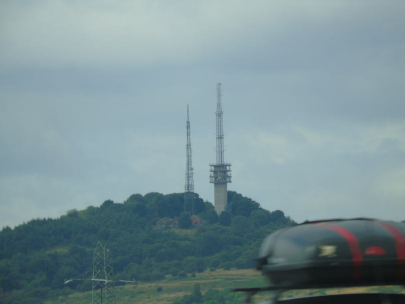
Leaving Carmarthen behind us, we joined the M4 Motorway, heading East towards Wales’s second largest city, Swansea…

Swansea:

Status: City & County of Swansea (historically Glamorgan), City, Wales

Date: 09/09/2015

Travel: Car

Eating & Sleeping: N/A

Attractions: Swansea Castle, Castle Square, South Dock Marina, Prince of Wales Marina, King’s Dock, Queen’s Dock, The Grand Hotel, Central Police Station, Cross Keys Inn, St Mary’s Church, Sail Bridge, BT Tower, River Tawe, Dylan Thomas Centre, Morgan’s Hotel, Exchange Building, The Tower – Meridian Quay, Swansea Guildhall etc

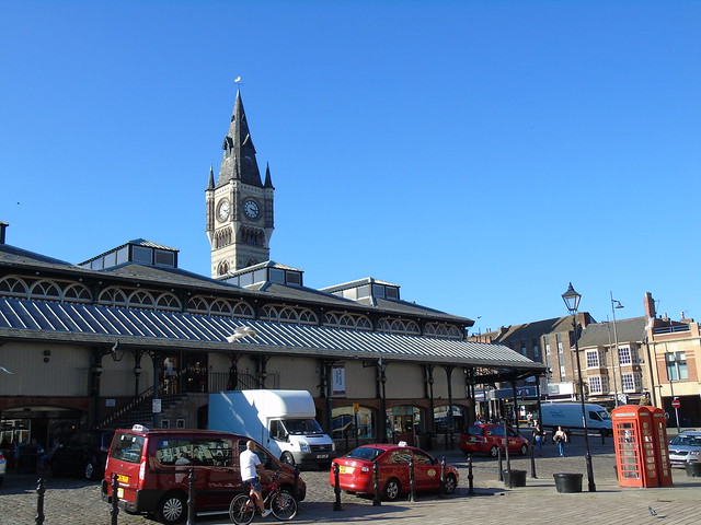
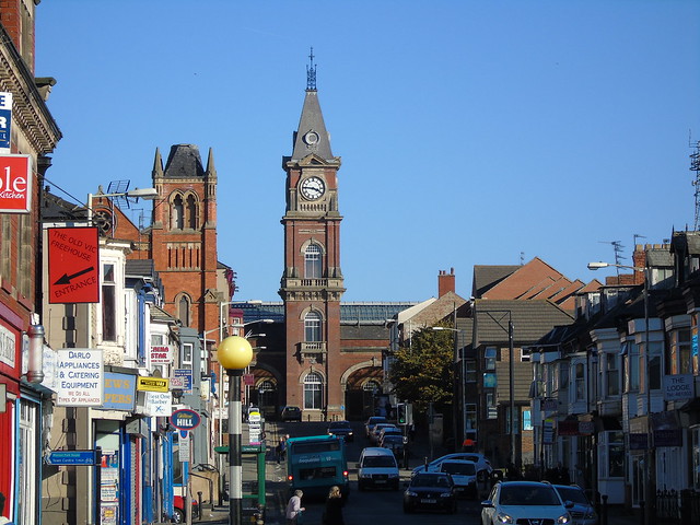
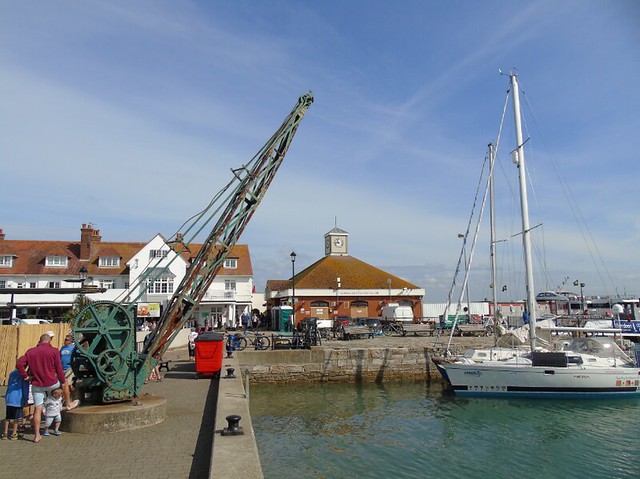
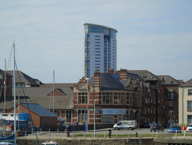
We arrived in Swansea at a large multi-storey car park opposite the main Railway Station, and as luck would have it we entered via the rooftop level entrance. From here we got a stunning view out across the Swansea Skyline, which was awash with various items of interest, from Clock Towers to Skyscrapers, Bridges to the Docks in the distance on the left. We were certainly in for a treat, yet before we had even walked a few metres out of the Car Park, we were coming face to face with some of Swansea’s architectural/historical gems…

Just outside the entrance to the Car Park lies “The Great National, Grand Hotel”, a fine building which dates back to the 1930’s. This elegant, streamlined building was built opposite the main railway station in the city, almost 80 years after trains began to transport passengers into, and out of Swansea. For many it was one of the first buildings they would see after leaving their train, so it had to look the part. It remains in business, as a privately owned hotel with a 3 Star (***) rating, and for any of you thinking of travelling by train, or just visiting for a few days, it must surely be the ideal place to stay. You can find out more on their official website here.

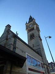
Swansea railway station is an architectural gem in it’s own right, and was originally opened in 1850 by the South Wales Railway, which soon became a part of the GWR (Great Western Railway) in the 1860’s. It remains 1 of Wales’s busiest stations, and is located off a small spur of the South Wales Mainline, itself a branch of the Great Western Railway from London, diverging near Bristol into South Wales. It runs on from Swansea towards Milford Haven and Fishguard, West of the city. From both of these, ferries are available over to the Republic of Ireland, making it a key route in the area. As Swansea is on the spur, trains continuing West into Wales, or East to London have to reverse back out to the mainline.

Swansea 5

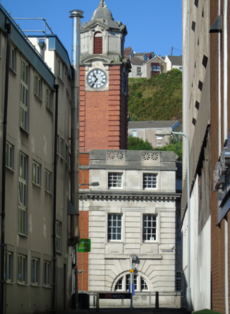
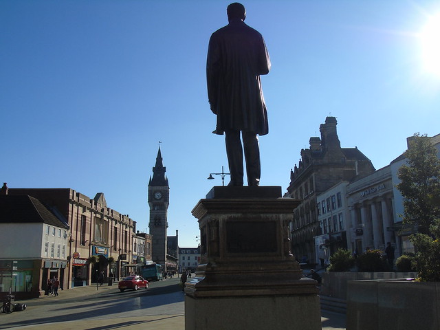
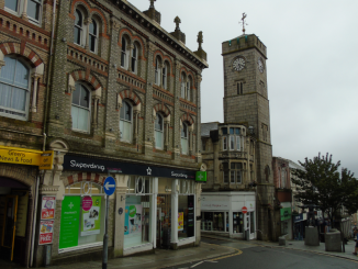
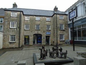
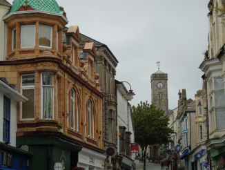
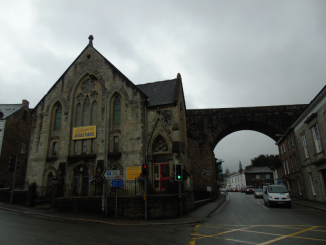
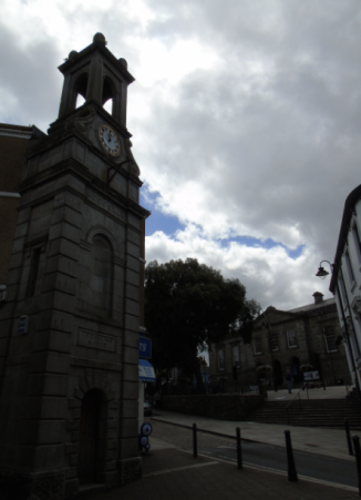
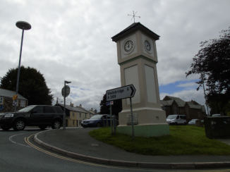
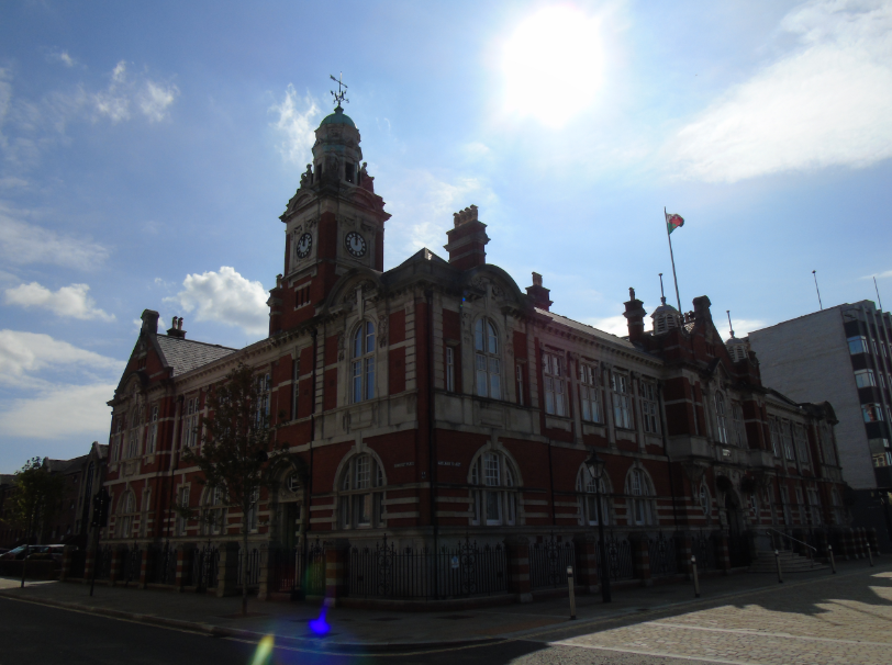
Moving on towards the city centre, we were happily strolling along, glancing up various side streets at the many shops and other buildings, when we spotted a large Clock Tower, later revealed to be called the “Llys Glas Clock Tower”. It sits atop the former Central Police Station, designed by Ernest Morgan (1881 – 1954, Architect from Wales employed as Swansea Borough Architect), and completed in 1913. The outer walls, alongside the red brick, are clad in Portland Stone, and the Clock Tower rises above the surrounding structures, a stunning sight.

South Wales Police no longer inhabit the building, and it was sold for redevelopment in 2003. It now houses a variety of student accommodation along with an Art Gallery and a Cafe, preserving another part of the city’s heritage for the future.

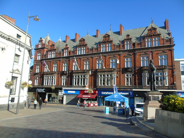
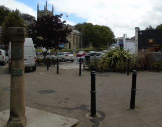
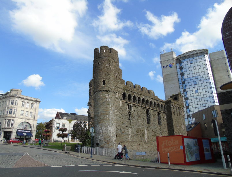
At the very heart of the city centre is Castle Square, a pleasant public space where you can relax and enjoy one of Swansea’s most famous landmarks, the ruins of the Castle shown at the back of the picture.

The square has a similar history to Piccadilly Gardens in the centre of Manchester, which was once a large public garden, later paved over and refurbished with a central fountain. Castle Square was the same, a large square garden full of trees, shrubs and other types of foliage, until a large redevelopment in the 1990’s gave it the look and feel we all see today. Whilst the new square has been quite controversial over its design, I personally rather like it, as it looks modern, is nice and open plan and gives a great view at the surrounding buildings. The centrepiece of the development is the circular fountain, which is fed by water cascading down the steps above it, from the large glass leaf at the top.

Behind the Castle is the Swansea BT Tower built in the 1970’s, the second tallest building in the city, at 200 ft. It does slightly overshadow the Castle, however its height makes it one of the cities major landmarks, creating a mixture of old and new within the square, of which only the centuries divide.

Swansea 7

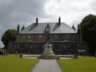
The Castle itself was founded by Henry de Beaumont in 1106, 40 years after the Norman Invasion of England, and later Wales. Henry was the son of Roger de Beaumont (1015 – 1094) an advisor to none other than William the Conqueror, making the family very important amongst the Norman lords.

Henry was granted various lands in the English Midlands by Williams successor, his third son William II (1056 – 1100), and he became the 1st Earl of Warwick. Henry remained in royal favour, leading to King Henry I (1068 – 1135, fourth son of William the Conqueror) gifting him “Gower” a large area of land in South Wales which covered Swansea, the Gower Peninsula and the Mumbles etc. He established a large Castle, which endured various attacks by the Welsh, finally falling in 1217. It remained unde Welsh rule until the Welsh Ruler Llywelyn the Great (1172 – 1240) made a settlement with the English King Henry III (1207 – 1272). The Castle was rebuilt with thick stone walls, whilst the surviving sections you see here (the South Block) were a later addition, a new part of the Castle built inside the Outer Walls by the 14th century.

By the 18th century it was in use as a prison, and it slowly declined in importance, so much so that part of it was knocked down to make way for offices. It is only more recently that the remains have been preserved, and it remains part of the rich history of Swansea.

Swansea 9

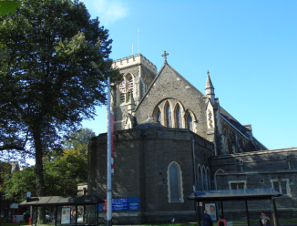
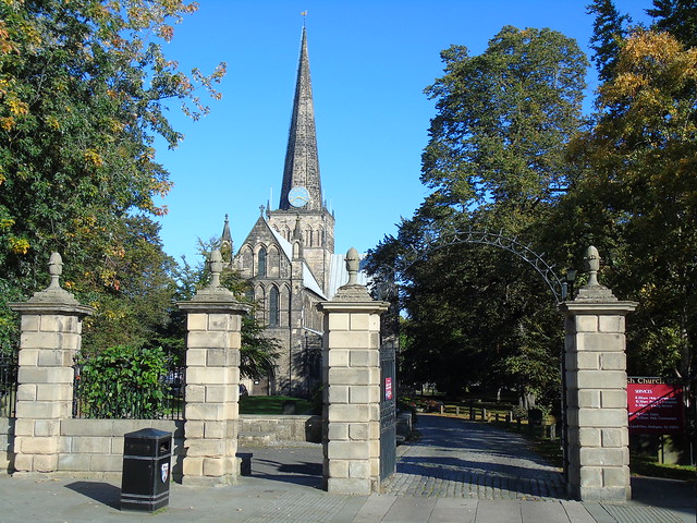
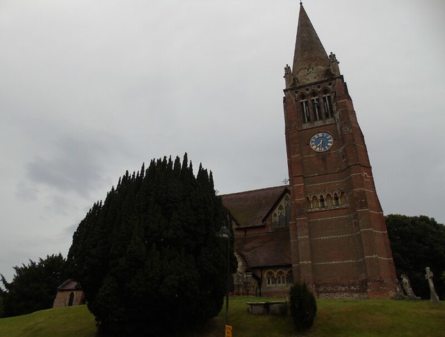
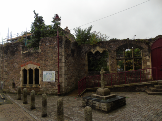
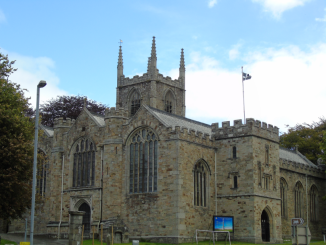
Just across the road from Castle Square on Princess Way is the stunning Church of St Mary’s, the largest Church in the entire city. It must also be one of the oldest buildings in the city, as it was founded sometime around the mid 12th century. Presumably it too was damaged in various attacks on the city much like the Castle, particularly as a large group of supports of Owain Glyndwr (1349 – 1415, Welsh Ruler) ransacked the city in 1403. The Church obviously survived however as it underwent various rebuilds later in life, in fact totalling one a century from the 18th onwards! In the 18th Thomas Woodward, an architect from the English city of Worcester crafted a brand new Nave, followed by a full rebuild in 1869 by yet another Architect, this time Sir Arthur Blomfield (1829 – 1899) from London.

Now this is where the extensive restorations should have ended, and the Church would have continued to prosper, thriving still today. But sadly it was not to be. Fast forward to the 19th February 1941, as the German Luftwaffe began to bomb the important port of Swansea, with the city centre taking a lot of hits. By the time the “Swansea Blitz” had ended on the 21st, hundreds of people were dead, and the entire city centre reduced to rubble. One particular casualty of this was St Mary’s, completed gutted by fire, and destined to stand as a ruin for the next 10 years, finally being restored to it’s former glory during the late 1950’s. It remains one of Swansea’s most important Churches, and is a welcome addition to the rebuilt city centre, a fine piece of Welsh history preserved, despite the terror of 1941.

Swansea 10

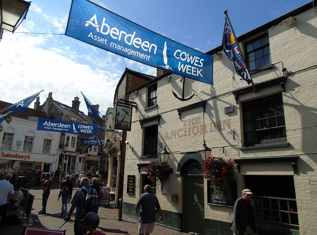
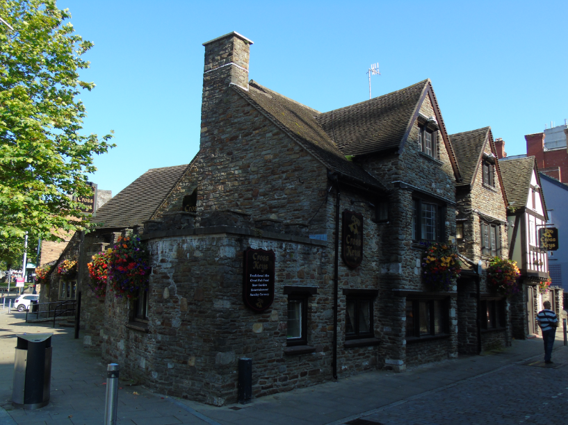
Just across the road is another historic building, the “Cross Keys” public house, which has been trading for the last 300 years! Upon closer inspection however, it’s history is much, much older, and it began life as a building which is a far cry from being a place of public drinking.

In 1332, Bishop Henry de Gower of St David’s Cathedral in Pembrokeshire founded a Hospice here, run by Priests in service to the Church. It survived Owain Glyndwr’s supporters attack on Swansea, although it is noted on the Cross Keys official website that it caused the old hospice to be reroofed, so it may have been set alight. The Monasteries across England & Wales were later dissolved by King Henry VIII (1491 – 1547, King of England) starting in the 1530’s, and the Church also suffered, as what had been the Catholic Church was expelled, and replaced by the Church of England. Whilst Henry himself didn’t touch the Swansea hospice, his son Edward VI (1537 – 1553) took over where Henry left off, and the hospice was closed by 1544. The land was bought by Sir George Herbert, who converted the derelict hospice buildings into a complex that eventually became the Cross Keys Inn, still trading today.

It’s a beautiful little building, and it says on the British Listed Buildings website that it was once just one building on a long street, rather than a standalone building as it is now. With the cobbles outside on the street, it must have been quite a scene to walk through Swansea a few centuries ago, and the Cross Keys still provides a little snapshot of times gone. You can find out more about the building on their official website here.

Swansea 20

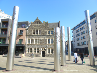
Moving on towards the Marina, we passed a large art installation along Princess Way, made up of five columns crafted out of Steel. They have interestingly been arranged to mimic the shape of the constellation Cassiopeia, and each features various images related to both Swansea’s maritime history such as the sea, as well as the weather, the stars and maps, making them as much a journey of discovery as we were having following the trail of historic landmarks in the city.

The installation was approved by Swansea City Council in 2005 and it has been designed as a stepping stone between the City Centre/Castle Square, and the National Waterfront Museum, which opened the same year. Sadly we didn’t have time to visit the Museum, but you can find out more about it on their official website here.

Swansea 12

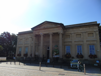
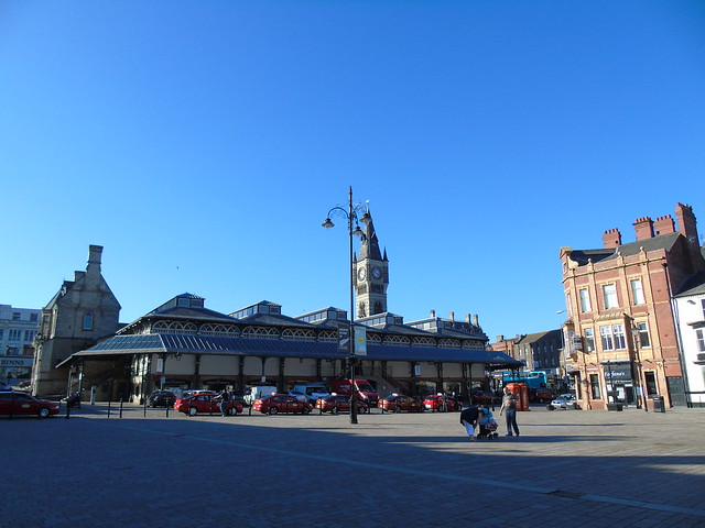
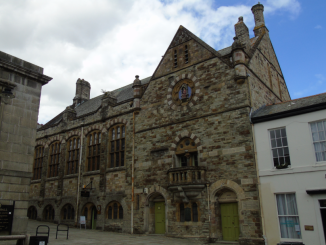
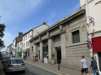
Our next stop was the Museum of Swansea, not far away from the National Waterfront Museum, which happens to be the oldest Museum in the whole of Wales, dating back to 1841. It was founded by the Royal Institute of South Wales, which itself was only created in 1835, and is still going strong today.

The building housing the Museum, characterised by the large columns around the entrance, was designed by a Liverpudlian Architect named Mr F Long, and was completed in 1841, a purpose built home for the Museum. The Museum itself has expanded over the years and is no longer contained within just one building, with branches around the Marina, Dylan Thomas Square and an outer suburb of the city called Landore.

Swansea is a proud maritime city, and as such has generated a large amount of historical artefacts such as various ships (on show in the Marina) and their treasures, as well as other local products from the last few centuries. You can find out more about the Museum on their official website here.

Swansea 13

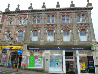
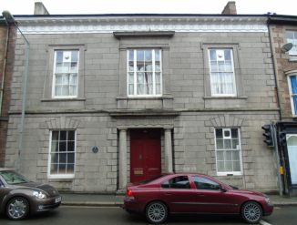
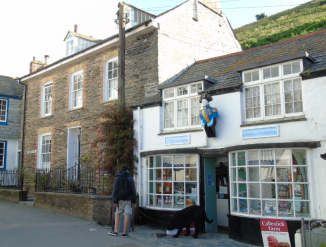
Just across the road is another building of note, located on the corner of Adelaide Street/Cambrian Place. You can see it in the 2nd picture to the left, with the edge of the Museum on the right to show you how close they are to each other. After visiting we knew it was the former Swansea Exchange Building, designed by Charles T Ruthen (Died 1926, Architect from Swansea), and completed in 1914. For a while that was all I could find, however by chance I stumbled across the website of Bevan Buckland, a firm of Chartered Accountants. Within their history page here I found this:

“In 1912 a company was formed by members of Swansea Chamber of Commerce under the name of Swansea Exchange Buildings Limited to erect a building on the corner of Adelaide Street and Cambrian Place in the Docks area. It was to provide a meeting place for ship owners, ship brokers and coal and general cargo exporters and their agents and also, on the floors above the Exchange, three floors of offices. The building was completed in 1916 and Frank Bevan who had, by this time, acquired a number of clients, moved from Wind Street into rooms 62 and 63 Exchange Buildings.”

So this explains the origins of the finely sculpted Exchange, and it ties in rather well with yet another neighbouring building, one of Swansea’s most architecturally famous structures…

Swansea 14

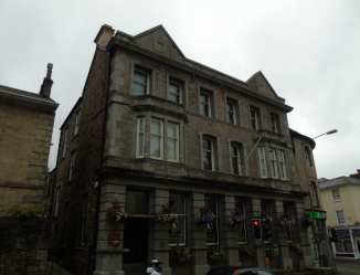
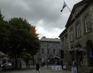
If you head North along Adelaide Street from the Exchange, past the junction with Pier Street, you will find yourself stood outside this truly magnificent building, which at first glance I assumed must have been the City Hall.

It was in fact built as the new HQ of the Harbour Trust, who had controlled the import/export of goods entering the city from all over the world since the late 18th century, with one important commodity being Coal, shipped from Swansea to various destinations.

The architect responsible for what has quickly become one of my favourite buildings in Wales outside of Cardiff, was Edwin Seward (1853 – 1924, Cardiff Architect), with the then Mayor of Swansea, Griffith Thomas, laying the foundation stone in early 1902, using an ivory handled trowel which was then gifted to the Swansea Museum, and is still there today. The fine Clock Tower was decorated by figurines designed by an Italian called Marco Fabbeni, modelled after a local lady called Frances Grey.

It remained in use as the HQ of the Harbour Trust until 1991 when a new building was completed out in the Docks, and it was converted into a hotel called “Morgans”, who still inhabit the building. This entire area of the city escaped major damage during the Blitz, which is incredible considering the devastation caused to the City Centre, so we still have Morgans, the Museum, the Exchange and many other historical buildings preserving Swansea’s heritage, including one other in particular that I shall get to later.

Swansea 15

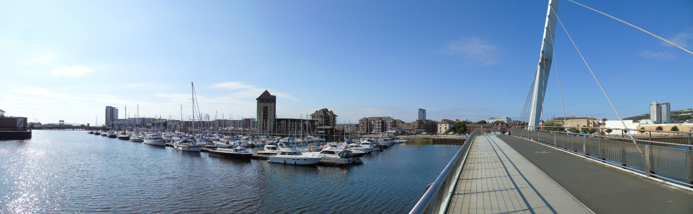
Leaving Morgan’s behind us, we continued on towards the Docks, and arrived at the Sail Bridge, which crosses the River Tawe, taking you out of the City Centre towards the waterfront. Designed by a firm of architects called Wilkinson Eyre (London Firm who also designed the Millennium Bridge in Gateshead), it opened in 2003 and is a major part of the waterfront regeneration in Swansea, which has become one of the city’s most popular areas.

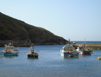
Looking back from the far side of the Bridge, you get a stunning view out across the Tawe, with the many boats moored on it’s banks. If you look at the far side of the Tawe to the right, there is a series of tall apartment buildings, one of which is topped by a pyramid shape. Behind it lies the Marina, which was originally dug out in the 1850’s as the South Dock, before it closed in 1969. By 1982 it had been redeveloped for use as a Marina, with apartments and boating berths constructed around it.

The South Dock was the second major dock to be built, after the North Dock in 1852. Sadly the North Dock was closed down in 1930 after the much larger King’s Dock (1905) and Queen’s Dock (1920) were built to handle the growing amount of trade passing through the city.

Swansea 21

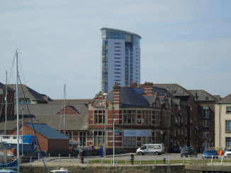
If you look closely at the previous picture, you can just see a large tower protruding above the rooftops of it’s surroundings, between the moored boats and the Sail Bridge. At first glance it just looks like another modern apartment building, but it is in fact the tallest building in both Swansea, and Wales as a whole, beating anything currently standing in the Welsh Capital, Cardiff.

Officially called the “The Tower, Meridian Quay”, it has a total height of 351 ft, spread out across 29 floors. The BT Tower in Castle Square is only 200 ft, making The Tower the best part of double it’s height. It took 3 years to complete, opening in 2009 with a mixture of residential apartments and a restaurant across 27th – 29th floors whilst the Penthouse occupies the 26th.

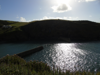
Wandering around the waterfront, we soon came across another of Swansea’s historic docks, in the form of the “Prince of Wales Dock”, which opened in 1881, with the then Prince of Wales, the future Edward VII (1841 – 1910) in attendance. It was the third dock to be completed, after both North/South, preceding the Kings/Queens Docks by almost 30 years.

It is no longer in use for handling cargo, and has instead become another Marina, renamed the Prince of Wales Marina. Looking past the new Marina however you can see a long line of Cranes, which line the edges of the King’s Dock, which is now Swansea’s main Dock for cargo imports/exports. The Queens Docks, even further beyond it is still in commercial use, although not in the way you might expect, as it is in fact used for Mussel Farming.

Swansea was once a thriving port city, and of course still is on a smaller scale. Coal, Zinc and various other commodities were major exports of the city, along with Copper, of which Swansea was providing the majority of for both the UK and the rest of the world.

Exploring the old Prince of Wales Dock, we came across another local landmark, the quaint little Norwegian Church, which is mirrored by its counterpart over in Cardiff, also down by the waterfront. It’s construction is closely linked with the wider activities of the Docks, which included frequent visits by sailors from numerous countries, including Norway. Interestingly however, the actual building itself was first erected by the Docks in the City of Newport, before being relocated to the banks of the Tawe in Swansea in 1910. It would serve the many sailors passing through Swansea from Norway until 1966, when trade had dropped to the point where it was no longer necessary, and the Norwegian Church closed it down. Luckily for the Church, it was taken over by a local man named Eric Benneche, also from Norway, who kept it going until 1998, when it closed for good.

2004 saw a complete restoration of the historic building, when it was taken apart piece by piece, refurbished and relocated here to the Prince of Wales Dock, and whilst it’s future use remains uncertain, it will certainly be a proud symbol of Swansea for generations to come.

Swansea 18

Circling back round the Docks, we began to head back into the City Centre, and as we approached the Morgans Hotel, we passed another building in the historic group which includes the aforementioned Morgans, the Swansea Museum and the Exchange Building.

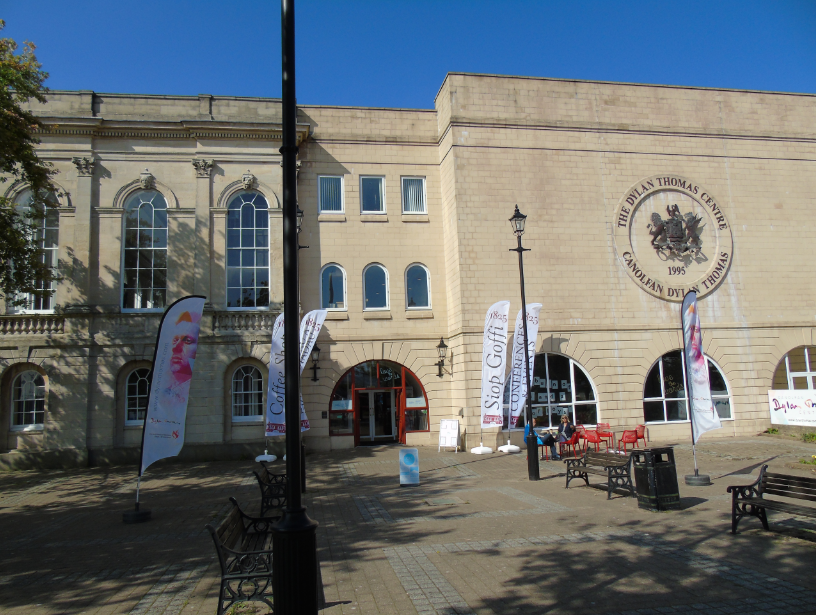
This was once the Swansea Guildhall as designed by John Collingwood, which first opened it’s doors in 1829 as the new home of local government in Swansea. Just ten years later however, the Municipal Corporations Act (1835) came into effect, which basically stated that the existing boroughs in England & Wales were no longer fit for purpose, and reorganised them significantly, with many, including Swansea, thus growing in size. This meant that the new Guildhall was already too small for the number of staff/functions needed to run the new area, so an extension was designed by an architect called Thomas Taylor. Now, looking at the building I assume the extension is the block to the right where the circular Dylan Thomas Centre inscription is located, as it is in a slightly different style to the rest of the building.

It remained in use until the 1930’s, when a whole new building altogether was envisaged, and resulted in the construction of a magnificent new Guildhall with a stunning Clock Tower watching over the city, further out past the Marina. That building is still used by the Council, along with the new County Hall complex built in the 1930’s. So that left the original Guildhall vacant for a number of years, later seeing use as an Army Barracks and a School. The Dylan Thomas Centre was opened in 1995, as the “Ty Llen”, which in Welsh means “House of Literature”, commemorating both the works of Dylan Thomas (1914 – 1953, Famous Welsh Poet) as well as literature as a wider field.

Find out more about visiting the centre on their official website here.

Swansea 19

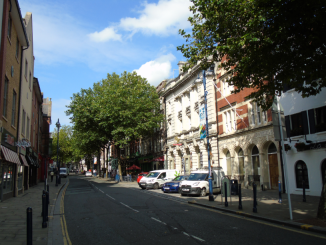
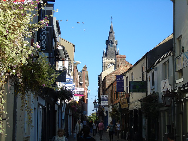
Casually heading back towards the car, we wandered up a small road called “Wind Street”, which connects the ring road near the Morgan’s Hotel with Castle Square. Despite the terrible bombing to hit the city during the War, Wind Street appears to have one of the largest concentrations of Listed Buildings in the city centre, and judging by the architecture up and down the street I would say a reasonable portion of it remained standing after the Blitz. Going off the British Listed Buildings Website, a great number of these appear to be located at the Castle Square end, on both sides of the street.

It is a nice little reminder of what Swansea may have looked like at the turn of the 20th century, and as we admired the charming outer facade of it’s many shops, restaurants and bars, our journey through Swansea came to an end. It’s a beautiful place, with a rich array of heritage, architecture, and scenery. The city made its mark on both Wales and the United Kingdom, and I can’t wait to return one day in the future.

Travel wise, it is well linked, with the M4 providing quick, direct access to the rest of South Wales, around Cardiff/Newport, and then on into England where it has connections with the M5 (South for Cornwall/Devon/Somerset, North for Birmingham and the M6 towards the North/Scotland) and then ploughs its way through towards London. The M4 is closely followed by the mainline through South Wales which transits through the Severn Tunnel into England, and again meets the Mainline near Bristol where you can change for the rest of the UK. There is only one major international airport in Wales, located near Cardiff less than an hour down the M4, with domestic and international flights available.

Swansea is one of our favourite Welsh destinations, and it’s great to see how so much history has survived misery and destruction, to shine out in the 21st century as a truly inspiring city. We soon left Swansea behind us, as we joined the M4, heading for Newport…