Day Trip To Durham and Newcastle: Pt 3 – Gateshead, Tyne & Wear, England

Directly opposite Newcastle is the town of Gateshead, which sometimes gets overlooked thanks to it’s much larger neighbour, however there is still much to explore in the town…

Gateshead:

Status: Gateshead District, Tyne & Wear, England

Date:  Various

Travel: Scotrail (Carlisle – Newcastle)

Eating & Sleeping: N/A

Attractions: Angel of the North, The Sage Gateshead, Baltic Centre, River Tyne, Old Town Hall, Redheugh Bridge, Millennium Bridge, Tyne Bridge, Queen Elizabeth II Bridge, King Edward VII Bridge, High Level Bridge, Swing Bridge

Angel2

Arguably the most famous landmark in the town, is the incredible “Angel of the North” sculpture by Anthony Gormley (Born 1950, British Sculptor) who is also responsible for “Another Place” on Crosby Beach. We have visited the towering giant by car, and it is also visible from the East Coast Main Line between Durham and Newcastle.

See Gemma’s dedicated post here to learn all about this giant sculpture, and how it looks in both the sun and fog…

Gateshead 1

Moving into the centre of Newcastle, you will find the Old Town Hall, built in 1870. This lovely old building has had a long and varied history, starting as the magistrates, courts and prison when it opened, as well as housing space for offices. A few decades later it became a Victorian Music Hall, and whilst the nearby Sage Gateshead was being constructed it was the home of the Northern Sinfonia. It’s most recent use has been as the Tyneside Cinema. Regular performances and live events are held here throughout the year and it has been lovingly restored.

It is located just over the Tyne Bridge from Newcastle. The Town Council now meets at Gateshead Council Building  a bit further into the town. The Old Town Hall is a Grade II Listed Building, along with it’s neighbour…

Gateshead 2

Off to the left of the Old Town Hall is another Grade II Listed Building, which was once the National Provincial Bank. It is quite similar to the Town Hall, and was built in 1871, to a design by an architect named John Gibson. The bank itself was established in 1833, and operated until 1970 when it merged with the National Westminster Bank.

Gateshead 3

One of the newer developments is the Sage Gateshead, shown here on the left hand side of the River Tyne. You get the best views of the building from the Newcastle side, but it is a Gateshead Building.

The Sage is a large theatre and conference centre, one of the largest in the North of England. The incredible arched design was put forwards by a collection of Architects: Foster and Partners, Buro Happold, Mott MacDonald and Arup.

The new building finally opened in 2004 after years of planning and construction, and the glass front offers incredible views out over Newcastle. There are three large theatres, one that can hold 1,700, one that can hold 450 and the third is a smaller rehearsal room.

The building is one of the main parts of the redeveloped Gateshead Quays, and opposite it is another popular part of the Quays, the Baltic Centre for Contemporary Art.

Gateshead 4

The Baltic is housed in an old flour mill, named the Baltic Flour Mill. This was opened in 1950 for the Rank Hovic company (Now RHM plc, founded in 1875, food company). An extension in 1957 can be seen on the left hand side of the building. It eventually closed in 1981 and the area lay derelict until the 2000’s, and it was refurbished with the Art Installation opening in 2002.

Despite some ups and downs, the Baltic is quite popular in the area, and there are a number of interesting galleries and exhibitions inside.

Of course from Gateshead the 7 bridges across the Tyne can be seen, with the newest one, the Gateshead Millennium Bridge, being named after the town (shown in the first picture). All of these bridges are as much Gatesheads as they are Newcastles, even though they are associated more with the city. You get some great views walking down the river on the Gateshead side as well as crossing the bridges themselves. Find out more about the history of the bridges in my Newcastle post as I go through them one by one.

Also, along this side of the river Tyne there are a number of small art installations, such as the Goats created by Sally Matthews in 1992. They are made out of recycled materials and are foraging up a small bank next to the river. Next are the giant rivets designed by Andrew McKeown in 2010. Local children made casts of their favourite objects and these are held inside the rivets, with the name of the item on the front of the rivet itself.

Next is the “Rise and Fall” by Lulu Quinn in 2007, the large glass and metal arch that stands six metres tall and represents a meeting point. It stands next to the High Level Bridge.

The final one we saw is on the way down from the road crossing the Tyne Bridge to the quayside, and takes the form of a stone violin. It is a monument to a Fiddler named James Hill (1811 – 1953, British Fiddler from Newcastle/Gateshead) and listed next to the monument are the names of many of his songs.

Check out a link here provided by Gateshead Council to find out more about the sculptures and also the locations of others in the area.

Gateshead is a very interesting town, and there are other things to discover including the Heritage Centre next to the Tyne Bridge, and the Library further into the centre. Just outside the town is the well known MetroCentre Shopping Centre, the largest shopping centre in the UK with over 340 shops. It opened back in 1986 and has been a huge hit and commercial success in the area.

Transport wise, there are Metro links (to Newcastle, Sunderland and South Shields) on the Tyne & Wear Metro from stations in the town centre and the nearby MetroCentre, as well as mainline stations at MetroCentre and the Dunston area of the town. Local buses run to Newcastle and other surrounding towns.

There is a lot to discover in Gateshead, and if you visit Newcastle try and make time to nip over into Gateshead, as it’s a worthy addition to any trip to the area. The Sage is an incredible architectural feat and one of the most beautiful builds we have seen so far. The Angel of the North is also one of the largest sculptures in the country and a symbol of the North, and easily accessible by tourist buses as well as by car, with the main line passing heading South from Gateshead.

Tyne & Wear is an amazing county, and Newcastle/Gateshead sits at it’s very heart, full of amazing buildings, great museums and buildings, and the finest collection of bridges in the world…

Day Trip To Durham and Newcastle: Pt 2 – Newcastle, Tyne & Wear, England

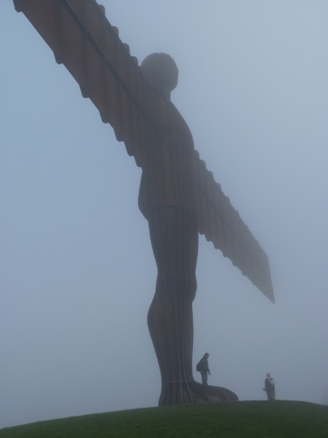
After spending an extraordinary morning in the city of Durham, we moved back past the Angel of the North, and through to Newcastle and Gateshead. We have been to Newcastle a few times since this trip so I have reorganised this post to add in some finds from our other trips and show you what the city has to offer.

Newcastle-upon-Tyne:

Status: City of Newcastle District, Tyne & Wear, City, England

Date: Various

Travel: East Coast (Newcastle – Berwick-upon-Tweed), Scotrail (Carlisle – Newcastle), Northern Rail (Newcastle – Middlesbrough)

Eating & Sleeping: N/A

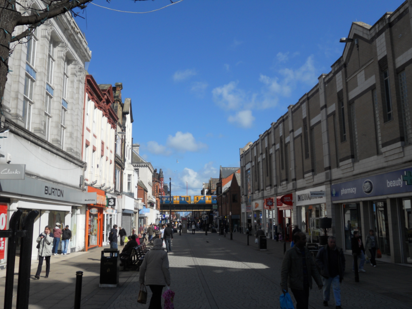
Attractions: Newcastle Cathedral, Newcastle Castle, River Tyne, Tyne Bridge, Redheugh Bridge, Tyne & Wear Metro, Grey’s Monument, Discovery Museum, Grey’s Monument, Gateshead Millennium Bridge, High Level Bridge, Queen Elizabeth II Metro Bridge, King Edward VII Bridge, Swing Bridge etc

The River Tyne flows between the City of Newcastle, and the town of Gateshead. It begins life as two separate rivers, the North Tyne and the South Tyne which meet near Hexham in Northumberland and then run through here and out into the North Sea at North & South Shields. The County of Tyne & Wear was created in 1974 and named after the Tyne, along with the River Wear that runs through the cities of Durham and Sunderland (Sunderland was also included in the county). Historically Newcastle was in Northumberland and Gateshead was in County Durham and the river marked the boundary between the two counties.

Newcastle 1

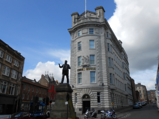
We left Newcastle Central station, which is in the heart of the city. There are a number of fantastic looking buildings around the city, including the above one, named Cross House. It opened in 1911, as an office block with 7 floors. It was also the scene of a deadly fire in 1919 when a large amount of celluloid film in the basement caught fire, killing 11 people, however it led to new laws to control how this volatile substance is stored and it no doubt saved many other lives for the future.

The statue in front of the building is of Joseph Cowen (1829 – 1900, MP for Newcastle in 1874) is one of a large number of statues and sculptures throughout Newcastle.

Newcastle 2

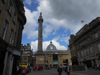
Moving further into the city centre, we went up Grainger Street to the pedestrianised sections approaching Grey’s Monument, the large column shown above. The column was erected in 1838, as a permanent memorial to Charles Grey, 2nd Earl Grey (1764 – 1845, UK Prime Minister between 1830 and 1834). A statue of Mr Grey stands on the very top of the column, and the situation is very reminiscent of Nelson’s Column in Trafalgar Square, London. It’s a very impressive sight as you approach it, and standing beneath it you gaze up at the very top, towering above you.

Behind the column is the entrance to Monument Mall, which opened in 1990. Monument Metro Station is also located in the square, with an entrance at either side. You can see one of the two on the right.

Newcastle 3

Also in this area, just down one of the streets off the square is the Theatre Royal, which opened in 1837. This fantastic building was designed by a group of local architects called John and Benjamin Green, a father and son team. The whole interior was redesigned in 1901, by Frank Matcham (1854 – 1920, English Architect), and because of this the restaurant inside the theatre is named after Matcham.

There are four levels in the main theatre, with enough space overall for 1294 people. It is a very well known local building, and regularly holds various productions, with the very first one back in 1837 being “The Merchant of Venice” by William Shakespeare from 1598.

Newcastle 4

Going back to Grey’s Monument and then down a road off to the left of the square, you will arrive at another square, which sits in the middle of the enormous Eldon Square Shopping Centre, which opened in 1977. There used to be a large terrace development in the area between 1824 and the 1960’s however most it was demolished to make way for the shopping centre.

The square itself is quite pleasant, with a large War Memorial in the centre, which features St George (Patron Saint of England) vanquishing a dragon, and unveiled in 1923.

The square itself was built between 1825 and 1840 making it part of the original terraced houses, with the shopping centre growing up around it. The designer was John Dobson (1787 – 1865, English Architect) and one side of terraced houses do still inhabit the square, at this side of the square.

Newcastle 5

Newcastle seems to be full of squares, and there is another on the other side of Eldon Square Shopping Centre. This contains the Church of St Thomas the Martyr, as well as the impressive Civic Centre which houses Newcastle City Council, and acts as the City Hall.

So, looking at the beautiful church that first greeted us, I was struck by the spires all around it, as well as the incredible tower which has a large space partway up between the columns, letting the light shine through. Another monument for St George stands outside the church on the right, with another poor dragon having met it’s fate at his hands.

A chapel was first built in the city in the 1170’s, by Hugh de Morville (Died 1202, Anglo-Norman Knight) who is one of four men convicted of murdering Thomas Becket, Archbishop of Canterbury, in 1170. He set up the chapel in memory of his victim. The chapel was located down by the river, next to the Swing Bridge, and it suffered greatly, being destroyed a number of times. The new church, on it’s present site, opened in 1830, and was also designed by John Dobson. The church doesn’t actually belong to any parishes, however there are regular services. It used to be associated with the Hospital of St Mary Magdalene, although it has long since gone.

Newcastle 6

Elsewhere in the square, the second main War memorial in the city is surrounded by brightly coloured flowerbeds showcasing a variety of different flowers. The monument itself is a large granite block, with thirty Bronze soldiers at the front, being led by a drummer. They are running off to war, and it commemorates the Northumberland Fusiliers, with children running alongside them waving them off. On the other side of the memorial is a carving of St George, with a pair of Sea Horses, which are part of the cities coat of arms.

Behind the memorial, the distinctive copper ribbed-dome of the Civic Centre rises high above the square. On top of each rib is the head of a Sea Horse which I mentioned just before. It is a great building, running almost the length of the far side of the square. It is quite similar to the one we saw in the Scottish town of Kirkcaldy, and was officially opened in 1968 by King Olav V of Norway (1903 – 1991). It is one of my favourite buildings in the city, there is something about old copper structures that have gone that lovely green colour that really captures my imagination, and there are plenty of them about.

Newcastle 7

There are a number of other interesting buildings in the vicinity of the square, including the adjacent University of Newcastle, as well as the above building, the Great North Museum: Hancock, which is split into three sections. The first is the Hancock Museum from 1884, the second is the Hatton Gallery from 1925 and then the Newcastle University Regional Resource Centre from the 2000’s. It is a very grand building, and covers a variety of exhibits from dinosaur skeletons to the Egyptians. The current museum was opened by Queen Elizabeth II in 2009, inheriting the collections of the previous museum and bringing everything in the building together.

Outside the museum stands a statue of William George Armstrong, 1st Baron Armstrong (1810 – 1900, industrialist from the city).

We pushed on, and made our way down the quay’s. We have been to Newcastle a few times, and there are 7 different bridges that cross the River Tyne from Newcastle City Centre over into the town of Gateshead. Before today we had only been over 5 of them, so we were determined to get the last 2.

The first bridge we crossed we have been over before in the car, but not on foot (not counting as 1 of the 2 we needed). It is called the Tyne Bridge, and you get some incredible views over the city from here, down to the various streets in and around the quayside, as well as two adjacent bridges.

The smaller of the two is the Swing Bridge, which was built to replace a series of older bridges along the Tyne, with the first Roman Bridge called Pons Aelius dating back to 122. Stone bridges followed in 1270 and 1781 after their predecessors subsequent destructions. The 1781 stone bridge was demolished to allow large ships to use the Tyne, and the Swing Bridge built in it’s place to allow both cars and river traffic. Normally it is in the straight position from one side of the river to other, but to allow river traffic it rotates so it’s vertical to it’s original position and boats can pass past on either side of the central pier. This is the 1st of the 2 we needed to complete our collection of bridges across the Tyne.

The other bridge is called the High Level Bridge, the oldest of the 7 standing bridges, which was built between 1847 and 1849 by Robert Stephenson (1803 – 1859, railway Engineer and son of George Stephenson who built the first inter-city train line to use Steam Engines, between Manchester and Liverpool). Together the six spans of the bridge run 407.8 metres, 12.2 metres wide. When this was built the Stone Bridge still existed, so there was a completely different landscape on the river back in those days. The colour scheme for the High Level Bridge is very similar to the Tyne Bridge, with the stone supports and the Green metal sections.

From here you can also see two other notable landmarks back in the city centre. The first of these is the impressive Cathedral, the lantern spire of which you can see rising above the single arch bridge crossing one the city streets. This is the Cathedral Church of St Nicholas, one of two Cathedrals in the city, with the other being St Mary’s Roman Catholic Cathedral which we will get to later.

It is a relatively low key cathedral compared to some of the others we have been to but the detail and architecture is no less impressive, especially the spire, which is known as a Lantern Spire, from 1448. We have seen similar ones in Belfast, Edinburgh and Aberdeen and its the only example we have seen so far in England. The tower overall is 59.89 metres tall, and the spire has four unique statues, one at each corner. They are of Adam – eating the Apple, Eve – Holding out the Apple, Aaron – Dressed as a Bishop and David – Holding a Harp.

It began life as the parish church in 1091, and it remained relatively stable since then. The Scottish took control the city in 1640 for a brief period, and properly in 1644 for nine weeks. The interior of the Cathedral was badly damaged and the spire and tower were under threat of burning, but the Mayor of Newcastle put the Scottish prisoners inside the tower to deter this. By 1882 the population of Newcastle grew so a new diocese was called for, and St Nicholas Parish Church was elevated Cathedral Status to head the new diocese. We have been inside and it is beautifully decorated and there is much to explore, from the exquisite stained glass windows to the imposing organ on one wall.

The second landmark is the Castle Keep, the tall square building with turrets near the end of the High Level Bridge in the city centre. It should come as no surprise that it was this Castle that gave the overall city it’s name. The Keep stands 81 feet tall and is easily visible from the platforms at Newcastle Central Station.

The first defensive site here was part of the Roman Fort of Pons Aelius which I mentioned earlier which also included the original bridge over the river. In 1080 a new wooden Castle was constructed by Robert Curthose (1054 – 1134, son of William the Conqueror). In 1095 the Earl of Northumbria captured the Castle and became a property of the crown. It was soon replaced by a stone keep between 1172 and 1250 by Henry II (1133 – 1189).

The next major section, the Black Gate, was added in 1250 by Henry III (1207 – 1272). The Black Gate also survives today and is just across the road from the Castle as you explore the city centre. It is so named, as one of the tenants who inhabited it later in it’s life was called Patrick Black. The Gate was leased by James I (1566 – 1625) to a courtier who altered it and rebuilt the top floors and then rented it out to different tenants, until it became part of a slum of the inner city housing up to 60 people at once. After new modern housing was being built the Gate was restored between 1883 and 1885 by the Society of Antiquaries of Newcastle and it is due to open in Summer 2014 as a Heritage Centre.

The Castle Keep went on to play a role in the English Civil War, when a garrison of 1,500 Royalists in support of King Charles I (1600 – 1649) attacked the city with a Scottish Army, and after three months of sieges the garrison surrendered from the Keep. For the next 200 years, until the 18th century, the Castle was used a prison, and by 1800 over fifty houses in habited the boundaries of the overall complex. It was bought by the Newcastle Corporation in 1809, and the houses inside demolished. In the mid 19th century a new railway viaduct was then built and crosses part of the site and is still there today. This meant that all parts were demolished aside from the Keep and the Gate. Both are now listed buildings.

Newcastle 8

So this is the Tyne Bridge itself, in all it’s glory. The Tyne Bridge, although only the 3rd oldest of the existing bridges, is the most iconic. The designers were an engineering firm called Mott, Hay and Anderson from London, who would go on to design the Forth Road Bridge in Edinburgh, and the Channel Tunnel between England and France. The design was based on the Hell Gate Bridge which opened in 1916 in New York City, USA.

The responsibility for building this colossal bridge fell to Dorman Long & Co from Middlesbrough and they started work in 1925, and completed the Bridge 3 years later in 1928. There are obvious parallels (even the same colour scheme) as the much larger Sydney Harbour Bridge, construction of which started 2 years before the Tyne, but only opened 4 years after the Tyne. The main reason for this is that it was built by the same company who built the Tyne Bridge and they actually helped to design it.

The Tyne Bridge was opened later that year by King George V (1865 – 1936) who made a special visit to the city. We were now on the Gateshead side of the Tyne but we soon crossed back over to Newcastle.

Newcastle 9

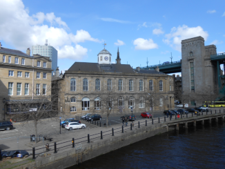
From here we crossed the Swing Bridge into the city. From the Swing Bridge you get a great view of the Guildhall, topped by the small white tower. It was the original Town Hall where the local government met. The original is from the 13th century, whilst the present building is from around 1658 when the previous building was enlarged by Robert Trollop, a local English Architect. It is used today as an overflow courthouse for the County Moot Hall (built in 1810) where most cases are tried.

Newcastle 10

From the Swing Bridge you also get a great view downstream, with the Sage Gateshead visible on the right hand side of the river. This is a major concert and theatre venue in Gateshead, which opened in 2004. The iconic reflective outer surface was glinting in the sun and it was an amazing sight.

Next to it, is the fourth of the 7 bridges, the Gateshead Millennium Bridge designed by Wilkinson Eyre and Gifford for the Millennium in 2000. It opened a year after the Millennium Celebrations, in 2001. It’s official opening came a year later in 2002. The whole thing was put into place as a signal unit, rather than being built over the river from scratch. One of the worlds largest floating cranes was used to hoist it into position, called the Asian Hercules II. The bridge also features on the British £1 from 2007.

The bridge has a rather interesting party piece. When a large boat or ship comes through, the whole thing tilts. On the pictures, the arch is holding the walkway up with cables. When it tilts the arch comes down and pulls up the walkway leaving a large gap for a boat to go through. It takes just 4 and a half minutes to complete the manoeuvre and completes it every now and then for events and sightseers.

Newcastle 11

From here we crossed back over to the Gateshead side to walk down to the 7th bridge to cross over again and get back round to the station. This is the 5th bridge down the river, and we walked underneath it on our journey.

This is the Queen Elizabeth Bridge which was built specifically for the Metro in 1976, to a design by W. A. Fairhurst & Partners from Glasgow. Construction took 2 years and it opened 3 years after completion, in 1981. Two companies helped build the structure, Cementation Construction Ltd and the Cleveland Bridge & Engineering Company from Darlington. Queen Elizabeth herself opened the bridge 11 days after the metro system opened.

Newcastle 12

As we crossed underneath the bridge, Gemma spotted a rather unusual art installation, a selection of Iron Goat sculptures on the embankment. These represent the fact that the name Gateshead may derive from “Goat’s Headland” as hundreds of years ago Goats roamed the area.

Newcastle 13

We kept walking, down to bridge number 6, the King Edward VII Bridge. This is the final railway bridge, which opened in 1906. Before this, all trains coming into Newcastle Station from the south used the High Level Bridge, but then to keep going out of the city back round South they would have to reverse back along the High Level. Now they could run round in a loop and back out over the new bridge.

Each bridge brings its own unique character to the city, and Newcastle wouldn’t be anywhere near as awesome if the 7 bridges didn’t own the skyline here. We had one more bridge to go, which we are going to walk across back into Newcastle, giving us the 7th and final bridge in our collection of bridges over the Tyne in Newcastle.

Newcastle 14

We climbed up the embankment and paused to look back at the bridge, the dull grey of the concrete contrasting well with the beautiful yellow of the newly flowered daffodils.

This one is called the Redheugh Bridge, a concrete traffic bridge. It is 897 metres long and opened in 1983, and is the third Redheugh bridge here. The first was designed by Thomas Bouch (1822 – 1880, whose Tay Rail Bridge at Dundee collapsed with a train running over it). Faults in the design soon emerged and it was demolished by the end of the decade. The second bridge opened in 1901, but again there were flaws and by the 1960’s it was demolished to build a new bridge.

Newcastle 15

The views from this bridge are fantastic, looking back across all the others to the Tyne Bridge. The spires of the city centre stand out well from here and a number of trains from Northern Rail, First Transpennine Express and East Coast all crossed at various times, so it’s a great spot for train spotters. I got this panoramic looking out from Newcastle, over the river into Gateshead. This is the furthest upstream you can cross the river to enter the city centre, and we finally could finally claim having been over all 7 bridges!

Newcastle 16

We crossed back into Newcastle City Centre, and went past the Centre for Life, a small science village with various attractions all about science, space and even a 4D Motion Ride. There are also other temporary exhibits that change all year round.

The centre opened in 2000, with Queen Elizabeth II present. It was designed by Sir Terry Farrell (Born in 1938, Arhictect from Manchester) and there is a variety of things for people of all ages to discover.

In the centre of the complex is the old Cattle Market Office, built in 1831, again by John Dobson. Originally it was the centre of a large cattle market, with the city walls also converging here, however it now stands alone, albeit in fantastic condition. It was also a toll house for crossings over the river.

Newcastle 17

As we moved back towards the City, we passed our last landmark, the Roman Catholic Cathedral of St Mary, built between 1842 and 1844. The designer was called Augustus Welby Pugin (1812 – 1852) and it is still in a fine condition today.

In 1850 a new diocese was required and St Mary’s was the perfect place to locate it, and it became the first Cathedral in the city (as St Nicholas’s didn’t get Cathedral status until 1882).

The spire is a fantastic height and stands out all over the city, and it is one of the tallest buildings in the city. Directly outside the building is a small monument garden dedicated to Basil Hume (1923 – 1999, local Monk) and a statue of him stands in the centre of the garden. A statue of Queen Victoria (1819 – 1901) stands outside St Nicholas’s Cathedral.

Newc 4

Transport wise, the whole county of Tyne & Wear is served by the Tyne and Wear Metro, a light rail system similar to the London Underground, although not as extensive. The network was opened in 1980 and makes use of existing lines around the county that were previously abandoned as well as new sections of track, as well as using the mainline through Sunderland at one point.

It is split into two lines, Yellow and Green.

Yellow:

The Yellow line begins at St James station in Newcastle City Centre. Most of the stations in the city centre are underground ones, including Monument shown above which is the 2nd stop on the line. The line then runs in a straight line to the coast at North Shields, round through Tynemouth and Whitley Bay, then back in land through the suburbs of Newcastle. It then comes back round through Monument (but not St James) then through Newcastle Central connecting to the mainline station, and then round through Gateshead to South Shields. The Shields Ferry also runs between North and South Shields and an all zone ticket on the metro includes using the ferry.

Green:

The Green line has its start at Newcastle Airport, before running round to Monument via the suburbs, through Newcastle Central then into Gateshead. It diverges from the same route as the Yellow Line at Pelaw stations and it heads out to Sunderland, over the river Wear and into Sunderland City Centre and round to South Hylton where it terminates.

Together the two lines serve 60 stations across all five districts in the county, with an overall length of 46.3 miles worth of track. The network uses overhead electric lines for power, and is one of only three light rail systems in the UK with the 3rd and smallest network being the Glasgow Subway.

The first time we visited Newcastle was last one November Evening, and we wandered down to the quayside and crossed the Millennium Bridge. The views at night are outstanding, with the sun setting behind the Tyne Bridge in a beautiful display. The Millennium Bridge also changes colour throughout the evening, from Red, to Green and then to Blue later on.

The East Coast Mainline from London to Edinburgh runs through the city, and is one of it’s major stops, with the line calling at Edinburgh, Berwick-upon-Tweed, York, Peterborough and London. Local travel connects the city to Durham, Middlesbrough and Carlisle. Newcastle International Airport just outside the city, and the A194 (M) leading from the A1 (M) terminates in Gateshead just outside the city. The only inner city piece of motorway is a very short piece of road making up the A167 (M) running from the Newcastle end of the Tyne Bridge through the city centre and out of the other side.

I hope you get a chance to visit Newcastle one day as there is a lot to discover, and crossing the bridges is a very rewarding experience.

Day Trip to North and South Shields: Pt 2 – South Shields

Our next stop was South Shields, on the South Bank of the River Tyne, in the historic county of Durham…

South Shields:

Status: South Tyneside District, Tyne & Wear (historically Durham), Town, England

Date: 04/04/2013

Travel: Northern Rail (Carlisle – Newcastle Central), Tyne & Wear Metro (Monument – North Shields), Shields Ferry (North Shields – South Shields) Tyne & Wear Metro (South Shields – Newcastle Central)

Eating & Sleeping: N/A

Attractions: Beach, Jubilee Clock Tower, Pleasureland, Lakeside Railway, Lake, North Marine Park, South Marine Park, Town Hall, Shields Ferry, Tyne & Wear Metro, Arbeia Roman Fort, Museum and Art Gallery, Tyne Lifeboat, Customs House Theatre, John Simpson Kirkpatrick Statue, Queen Victoria Statue etc

SShield 1

We had just arrived via the Shields Ferry from the neighbouring town of North Shields, on the North bank of the River Tyne, on a boat called the “Spirit of the Tyne”. The Ferry is the quickest way to get between the two, as the Metro only runs back along either side of the River and you would have to change back in Newcastle to get between the towns.

SShield 2

South Shields town centre is only a short walk away from the Ferry, and is a bustling area with plenty of shops, and well known high street brands. This street is called King Street, and interestly the bridge with the Tyne & Wear Metro train you can see further up the street is actually the Metro station itself. The main building is located to the right out of shot, and the platform itself is behind the train, also out of shot. We would find ourselves up there eventually at the end of the day as we made our way back towards Newcastle, but more on that later.

SShield 3

Moving up King Street, we came across a small square where a few roads intersect, which had a few Listed Buildings around the outside. The first is the Barclays Bank Building, shown above, from 1909. Banks always have these stunning old buildings, mainly because at the time they were the only companies who could afford to have them built, but they really add something to the high streets of Britain.

Designed by J H Morton, who worked with a company called J H Morton & Sons based in South Shields, the building has 3 storeys and sits on a corner, meaning the left side of the building is actually sat on Fowler Street rather than King Street.

SShield 4

This view is looking up Fowler Street, looking past the Barclays Bank Building up to Number 27 Fowler Street. This is located just past the tall building with the small dome on the top on the left side of the street, and was built in the 1860’s out of Red Brick, one of the Victorians enduring legacies. Red Brick is a prominent feature in South Shields, and is one of my personal favourite types of architecture.

SShield 5

Our next stop was the South Shields Museum & Art Gallery, just a little further up King Street. The Museum has a beautiful stone lion located outside on the pavement, and the collections themselves are in the lovely Grade Listed Building at the back of the picture.

Originally the building was created as the home of the local Mechanics Institute by John Wardle in 1858. 2 years later, the building was complete, and for the next 13 years it continued to house the Institute, until 173 when it was converted into a Public Library for the town. A Museum section was then added in 1876, which expanded after the Library was moved out to another area of town. There are also plans for a brand new Library to be constructed in 2015 as part of plans to renovate the Market Place, back towards the Shields Ferry.

Today the Museum contains many interesting exhibits, some of which focus on the Local Government District called South Tyneside that covers South Shields and the others towns and villages clustered around the South bank of the Tyne. Similarly North Shields is part of North Tyneside which covers the North bank of the river.

Coal mines were an important part of the local economy 100 years ago, and I even got a small model of a local lighthouse made out of coal from the Museum shop. Other exhibits show artefacts from the area as well as paintings going back centuries. Its a great place to visit, and you can learn much about this interesting little town.

The next building, on the other side of the street, is the this beautiful red brick construction which was originally opened as the South Shields Marine School, in 1869. A later addition to the building was then made in 1909, and for a number of years it remained it’s capacity as the Marine School. At some point in the last few decades the building was converted for use as a pub called “The Kirkpatrick”.

The building was named after John Simpson Kirkpatrick (1892 – 1915), a statue of whom stands outside the building, with a donkey stood behind him. John was a hero from South Shields who served in World War I, who helped to carry wounded soldiers away from the front line of Anzac Cove, Turkey, down to the beach to be rescued, using the donkey. He was sadly killed in the cove a few weeks later during the 3rd Attack on the Cove by the Ottomans, when he was hit by enemy fire.

SShield 8

We kept moving, towards South Marine Park, down near the seafront and the beach. As we reached the entrance to the park, we got a great view down the A183 which runs alongside the park, towards the towns Jubilee Clock Tower. In 1897 Queen Victoria (1819 – 1901) celebrated her Golden Jubilee, and in recognition of this J H Morton designed this stunning Clock Tower, created by John F Scott and R B Farbridge.

Standing an impressive 45 ft tall, the tower stands in front of a small covered building which contains an old Lifeboat of the town called the Tyne, from 1833, which you can just see protruding from the right hand side of the tower. For over 60 years it was in service for the town, saving lives and braving the rough seas, until 1894 when it was placed here, under a canopy built the same year, a permanent memorial for the public.

SShield 9

We entered the park, which as I said is called South Marine Park. On the other side of the A183 lives North Marine Park, the smaller of the two parks. South Marine is a vast open public space, which runs down towards the beach at the seafront.

Designed by the Victorians, whose passion for grandeur made it what it is today, the park has its origins with Matthew Hall, the designer who came up with the overall layout around 1886. John Peebles was immediately given the job of head gardener and started laying out the park, as the area it stands on was once covered by ballast and wastle. The work was completed by 1890 and the park opened to the joy of the residents of South Shields.

Some of the features of the park include this rather interesting sculpture which is based on a range of animals all designed by some school children from the area. Together they were incorporated into a new mythical animals, which appears to have the tail of a large serpent, the body of a dog or horse, with hooves and the head of a carnivore. Either way its an innovative design created by Richard Broderick for South Tyneside Council who originally commissioned the piece. The best design feature is the plinth it sits on, which was specifically designed to mirror the Victorian history of the park, and to make it fit in with the recently restored Victorian surroundings, railings and benchings.

On the 2nd picture, behind the trees to the right you can just see the form of the parks Bandstand. This was added as part of the restoration, and mirrors the 1st Bandstand which was installed in 1904, and built by a company called Macfarlane’s from Glasgow up in Scotland, although I am unsure what eventually happened to it.

At the bottom of the park, nearing the seafront, you will find the Marine Lake, where you can hire pedal boats to go for a relaxing ride across the water, or equally you could take a trip on the miniature railway which circles the lake, which a charming steam engine at the front. The park is a great place to explore and on such a nice day it was the perfect place to be.

SShield 14

Between the park and the beach lies the A183, on the other side of the which the golden sands stretch down towards the water. If you turned left and continued up the road you would also reach Ocean Beach Pleasure Park, a large fairground with various rides and attractions.

Its been a long time since we have seen such a sandy beach, as in my home town of Southport the beach is slowly being overtaken by foliage, and the sea wall has also limited the length of the beach itself. Being out here in Tyneside reminded us of somewhere abroad, with a vast beach and stunning seaside views.

SShield 15

From the beach we could see two notable landmarks, the first being the South Pier, which extends into the sea to act as a breakwater for the entrance to the Tyne for ships arriving and departing the river. The Pier was completed in the 1890’s, as the same time as its counterpart in Tynemouth, near North Shields, called the North Pier.

They both have Lighthouses as the end, added when the Piers were built, and we could see the South Shields Lighthouse from here. It’s an impressive site, and an engineering marvel as it took 54 years to complete the two piers, due to rough seas and the difficult location.

SShield 16

The other landmark we could see was the ruins of Tynemouth Castle, which despite looking reasonably close is actually on the other side of the river in the town of Tynemouth, near the North Pier. It sits on area of rock called Pen Bal Crag, and the ruins take in not just the Castle but also the associated Priory.

The Priory predates the Castle, when it was built in the 7th Century. The Priory is known for being the location of the graves of 3 Kings, the 1st being Oswin, king of Deira in 651. Deira was an area which takes in present day Northern England and the South-East of Scotland, around Berwickshire and Northumberland. The next King to be buried here was King Osred in 792. He was followed by the Scottish King Malcolm III who died in 1093 during the Battle of Alnwick, between the Scots and the English. The English eventually went on to win the battle.

By 1296 the Castle was begun, mainly as defences for the Priory itself, and consisted of tall stone walls, as well as a Gatehouse and Barbican. A lot of this still survives, along with ruins of the main building of the Priory, destroyed in 1538 by the Reformation under King Henry VIII. The Castle itself however was in a defensive position along the coast, and was retained with new artillery postings being located here, eventually becoming a barracks, and retaining its defensive importance during World War II. After the war it passed into the care of English Heritage, and it is open to the public for visits.

It’s an incredible site, the sheer scale of the area, and its position overlooking the sea.

SShield 17

That was the end of our exploration of South Shields, so we wandered back towards the Metro Station. The Metro was originally a number of local trains, which were eventually incorporated into one service together.

From the platform, which is elevated above the town, you get a great view of the local skyline. We also spotted the Clock Tower of South Shields Town Hall, which really stands out above the other buildings. It’s not often we get to this elevation, especially not outside, usually we would be looking through a glass window so it was nice to get this kind of view in a general setting.

The Town Hall dates back to 1910, and more recently in 2010 its celebrated its 100th anniversary. It was designed by Mr Ernest E Fetch from London in 1902, and work commenced in 1905. The Tower was topped out in 1908 and the rest of the building in 1910. As a memorial a statue of Queen Victoria was erected outside the building 3 years later, although it was later moved to an area called Chichester near the town, only to be returned finally in 1981.

SShield 18

The train arrived and we were soon our way back round towards Newcastle Central Station where the metro intersects with the mainline station, albeit on low level platforms. From there we caught the train back to Carlisle, and reflected on a very enjoyable day.

South Shields has regular metro services towards Newcastle, running through all local areas on route. The Shields Ferry also runs over the Tyne to North Shields where the Metro can be joined to travel round to Newcastle Airport as well as Tynemouth and Whitley Bay. The East Coast Mainline runs through Newcastle allowing passengers to get direct trains down through Durham, Darlington, York and Peterborough to London heading South, and North to Glasgow/Edinburgh via Berwick-upon-Tweed.

South Shields is a fascinating little town in a great location by the sea, with views to match. It’s an enjoyable place to visit, and we had a great time during out day out.

Day Trip to North and South Shields: Pt 1 – North Shields

For this trip we were literally sat at home the night before wondering what we would be doing all week, and this was about 7pm at night, when I suddenly came up with the idea of heading over to North and South Shields near Newcastle, as I hadn’t been that far down the River Tyne. We checked the trains, found connections on the metro service from Newcastle to North Shields and decided to do it. So less than 12 hours later we were getting up ready to travel…

North Shields

Status: North Tyneside District, Tyne & Wear (historically Northumberland), Town, England

Date: 04/04/2013

Travel: Northern Rail (Carlisle – Newcastle Central), Tyne & Wear Metro (Monument – North Shields), Shields Ferry (North Shields – South Shields) Tyne & Wear Metro (South Shields – Newcastle Central)

Eating & Sleeping: Cafe Nero

Attractions: River Tyne, Shields Ferry, Quayside, High Lighthouse, Low Lighthouse, Tynemouth Lighthouse, Wooden Dolly, North Pier, South Shields South Pier, South Shields Lighthouse, Herd Groyne & Lighthouse, Seafarers Anchor Memorial etc

NShield 1

We arrived in the town of North Shields after hopping on the Tyne & Wear Metro network at Newcastle. The Metro is quite extensive, and serves Newcastle, North Shields, South Shields, Sunderland and everywhere in between. North Shield’s station is located centrally in town, and we soon arrived in the main shopping areas.

There are a number of shopping centres in the area, with the main one being called “The Beacon Centre”. It contains all the usual shops you would expect from a town centre. After a quick browse we moved on, towards the sea front, to get a view of the River Tyne and the town on far bank of the river, called South Shields.

NShield 4

We soon arrived in a small square which is sat on top of a hill overlooking the river and the surrounding area. Within the square are two items of note:

1) Anchor Memorial

The 1st is a Memorial to seafarers lost out at sea, in the form of a large Anchor, a fitting tribute to those who have dedicated their lives to their ships and their comrades.

2) 1 Howard Street

This rather impressive looking building is Grade Listed, and has a completion date of 1807, when it was built as a home for the Tynemouth Literary & Philosophical Society. The building has 2 storeys, and the roof is topped by stunning Welsh Slate. Apparently the roundel visible on the side of the building was also once home to a clock, much like the one in the centre above the pillars around the doorway.

NShield 5

From the hill you get a great view of the various Beacons and Lighthouses which have helped guide sea travellers into the town. I apologise for the slightly blurred photograph, but its the best one I got. Aside from the Lighthouse at the end of the sea wall, there are two others, in the form of the tall, white square towers, sat down near the wharfs.

The one at the bottom is the Low Lighthouse, the original one built here in 1807 by Trinity House. It is attached to a small house to the right of the main Lighthouse, which was built later in 1816. The Light actually replaced the original Low Light, which was built along with an original High Light during the 16th century. In the 17th century Cliffords Fort was built around it, a large fortress designed to protect the town (and port) from a Dutch Attack. The Light eventually became redundant and the new Low Lighthouse was built. The original Light is still important however, as it is the oldest building in this area of the town.

A similar story exists with the High Light, the original of which sits behind it out of view. The new High Light dates from around the same time as the new Low Light, and both have a commanding presence here at the waterfront.

The 3rd Lighthouse, located at the end of the Sea Wall in the distance, which encloses the entrance to the Tyne, isn’t actually part of North Shields, but is instead located in the town of Tynemouth, and the Lighthouse is called Tynemouth Lighthouse. The building was completed in 1896, to mark the position of the Tynemouth sea wall (also known as the North Pier) which was completed in tandem with the South Pier on the far side of the River. Together the two Piers helped to shelter ships that were entering or leaving the Tyne here, and also stopped sand being washed in by the tide, and silting up the river. The Piers took an incredible 54 years to complete, due to rough seas and the huge task of battling an ever present sea. In 1897 the waves grew so mighty that part of the North Pier was washed away, leaving a large hole part way along it, but it was restored by 1909.

NShield 6

In this picture you can see over to South Shields, and the South Pier which I mentioned earlier. It too has a Lighthouse, completed at the same time as the Tynemouth one.

In the foreground, you may have spotted a secondary pier on the far bank of the river, which has a small red building at the end, behind the large antenna on the above picture. This is called Herd Groyne, and it, along with it’s small red Lighthouse, predates the two piers, as it was finished in 1882. It is still in use, although largely superceded now by the larger Lighthouses.

NShield 7

The view up here is brilliant, and you can see back West along the Tyne towards Newcastle, and the huge ports which serve the area, with the towering cranes of the busy docks visible in the distance.

NShield 8

There are information boards around the town that tell you a bit of history about buildings and bridges in the area as well as suggesting the best route to take to see everything. We had quite a long walk around the town once we left the square, and eventually ended up at the bottom of the hill, walking along the rivers edge.

One of the other landmarks of the town is the Wooden Dollies. In 1814 a figurehead of a Wooden Dolly was placed at the entrance to Custom House Quay, and replaced by a second in 1850. The sailors used it as a good luck charm and would cut bits off it to take with them, until eventually the second dolly was too badly damaged to continue, and a third was placed on the spot 14 years later, which then lasted through to 1901 when the fourth dolly arrived. A fifth was placed in the town but in a different location, in 1958, over in Northumberland Square, but a sixth was put in the original dolly position in 1992 and is still there today, standing next to the Prince of Wales public house.

NShield 9

We kept moving, and passed a number of interesting buildings, such as this one, although sadly I can’t find a build date for it. The quays here are quite extensive, and a lot of them have been redeveloped for the modern era.

NShield 10

Sat across from it though is “The Porthole Free House” which is actually made up of two separate buildings, as there are two separate listings covering the whole structure. The 1st of these relates to this front portion of the building, which is just called “The Porthole Free House” and is listed as dating back to 1897, replacing a previous building that once stood here. It was designed by a company called W & T R Milburn from the nearby city of Sunderland, and is a typical Victorian building with fine red brick used to great effect.

The 2nd Listed Building makes up the left edge of the building, which continues on down the side of the building out of site. This is known as Numbers 65, 66 & 67 Tynemouth Borough Road, and was built in 1856 by Benjamin Green for the 4th Duke of Northumberland, Algernon Percy (1792 – 1865), and was home to local sailors. It was later converted into offices, which it remains today.

As North and South Shields lie at opposite sides of the River Tyne, and there is no Metro crossing between the two, the easiest way to get between them is the Shields Ferry. If you have purchased an all day all zone Metro Ticket then this will cover the ferry otherwise you have to pay. They are hourly and it doesn’t take long to do the crossing. The North Shields Ferry Port is located just down from the Porthole, and the crossing affords great views up and down the River.

As the Ferry left, we got a great view back at the High & Low Lighthouses, and behind the High Light the original High Light came into view, a similar yet slightly smaller construction. In the distance we could also see the ruins of Tynemouth Castle, but we would get a much better view of that when we arrived in South Shields, so I’ll cover it later. The sun was shining, and glistening across the river, and looking back from where we had left we could see the long rectangular form of the Old Customs House, a lovely building which fits in well with the character of this area of town, serenaded by the long trail the boat had left.

There has been a ferry here between North and South Shields for centuries, but the modern version is known as the Shields Ferry, which replaced the Market Place Ferry in 1972. There have been 4 vessels in used on the service:

1) Freda Cunningham (Later Sold and Replaced)

2) Shieldsman (Later Sold and Replaced)

3) The Pride of the Tyne

4) The Spirit of the Tyne

We sailed on the Spirit of the Tyne, a great little boat which made our day. Overall it was a lovely day and sailing across the Tyne was lovely, with great views down at the docks, and just getting to go on a ferry was great because it was our first one together. It docked at the other side and we set off to explore South Shields, the larger of the towns…

Sunderland, Tyne & Wear, England

Following on from Durham and Newcastle, later that same month we headed back to Tyne & Wear, and this time we went down to the city of Sunderland, via Washington.

Sunderland (With Washington):

Status: City of Sunderland District, City (Town), England

Date: 25/11/2012

Travel: Car

Eating & Sleeping: N/A

Attractions: Wearmouth Bridge, Tyne & Wear Metro, Sunderland Minster, Stadium of Light, Riverside,  Riverside Sculptures, Empire Theatre, Museum & Winter Gardens, National Glass Centre, Washington Old Hall etc

Sunderland 1

On our way to Sunderland, we stopped briefly at the Galleries Shopping Centre in the town of Washington, just outside Sunderland. As we went in late November, all of the Christmas decorations were up so it was pleasant finding a bite to eat and looking at the decorations. We didn’t have time to see anything else in Washington itself but it does have an impressive hall as well as an arts centre.

Sunderland 2

We moved on, towards Sunderland and parked up near the Wearmouth bridge. It is similar looking to the Tyne Bridge in Newcastle, and was built in 1929, a third in a succession of bridges on the spot. This is the nearest bridge on the picture, and is a green colour. Behind it is the must shorter rail bridge, of the same design, which local trains as well as the Metro both use. The rail bridge is much older, dating back to 1879. These bridges are the final ones to cross the river Wear (which we previously saw in Durham) before it reaches the North Sea. Further up the river, we cross the Queen Alexandria bridge, a very impressive Truss Bridge built between 1907 and 1909.

Sunderland 3

The are various sculptures down the River Wear once you get passed the bridge. One of these is the above picture, which is in the shape of a tree, and constructed out of metal. There is a pattern on the floor in front of it, and when the sun shines at exactly the right angle during the day the shadow of the tree elongates and forms the pattern on the ground. We found this rather fascinating, however we weren’t there at the right time of day. Other sculptures include a massive nut, as well as a massive bolt that would slot into it.

Sunderland 4

We moved further down the river, and the docks with their large cranes were visible. It was a very pleasant area, but November might not be the best time of year to visit, it was absolutely freezing that day but we have a great time anyway. A lighthouse is visible at the end when you get further round, and is on the end of the two walls extending out to see to mark the entrance to the river. After moving down the river, we headed into the city centre, going past the main shopping centres, the central station and by the time we had gotten round it was getting dark.

Sunderland 5

This is the entrance to Sunderland Museum and Winter Gardens. The museum is notable for containing the only example of a gliding reptile in Britain.

The museum was opened in 1846, before moving to the current building 1879 and also contains a library, with the main Winter Garden at the back. The new building started construction in 1877, and the laying of the foundation stone even had the current US President Ulysses S Grant (1822 – 1885) in attendance. The library moved out of the building in 1995 leaving more space for extra exhibitions to be added to the museum.

During World War II the Winter Garden was hit by a bomb, and eventually demolished. In the 1960’s a new extension to the museum replaced it, and in 2001 a new Winter Garden was created.

Exhibitions inside include the first Nissan Car to be made in the city, and a Walrus from Siberia in the 1880’s.

Sunderland 6

Our last stop on the way back was Sunderland Minster, which was lit up in the dark and looked very impressive. The minster used to be the church of St Michael, however it was renamed in 1998 following Sunderland being awarded city status. Although churches on the site date back to 940 AD, the current church was rebuilt substantially in the 20th century, due to subsidence in the area.

Sunderland is a nice city, with some brilliant views around the river, as well as attractions such as the Museum and Winter Garden, and the Glass Centre that can keep families busy during the day, and for the football fans the impressive Stadium of Light is visible over the bridges from the city centre.

For transport, the Metro runs all the way back to Newcastle, and local trains run through to Middlesbrough and Stockton-on-Tees. Connections from Newcastle can take you up to Berwick-upon-Tweed and into Scotland, or South to York, Peterborough and London.

Art: Angel of the North

On our way to Durham, we decided to stop and have a look at one of the most famous landmarks in the north of England.

The Angel of the North is a sculpture by the artist Antony Gormley. The sculpture, which is made out of steel, is 20 metres (66 ft) with a wing span of 54 metres (177 ft). The Angel stands overlooking the A1 and A167 roads on the outskirts of Gateshead, Tyne and Wear.

When we first when to visit the Angel it was shrouded in mist, giving the area an eerie atmosphere.

Angel1

According to Gormley, there are three reasons why an angel is significant:

  1. To signify that beneath the spot where the Angel stands, coal miners had worked for 200 years.
  2. To grasp the transition from an industrial to and information age.
  3. To serve as a focus for our evolving hopes and fears.

Although the weather wasn’t perfect the fog did frame the Angel beautifully, and we couldn’t help but gaze upon it with awe.

Angel3

A side view of the Angel. You can just about make out the slight contours of its face.

The Angel was built at Hartlepool Steel Fabrications Ltd using Corten weather resistant steel. It was built to withstand winds of over 100 mph (160 km/h) and has concrete foundations weighing 600 tonnes which run 21 metres (70 ft) below the Angel, anchoring it to the rock.

The sculpture was built in three parts and brought to it’s roadside home to be constructed there. Each wing weighs 50 tonnes each and the body weighs 100 tonnes. It took 4 years to build and cost £800,000.

Angel2

On our way back from Durham we decided to stop by the Angel again, and thankfully the weather had picked up. The sun was shining and we could see the Angel in all its glory.

At first the Angel caused much controversy, but is now considered a landmark for North East England. It is often used in television and film to represent Tyneside, and is now a much loved icon of the North.